Andean Volcanic Belt
The Andean Volcanic Belt is a major volcanic belt along the Andean cordillera in Argentina, Bolivia, Chile, Colombia, Ecuador and Peru. It formed as a result of subduction of the Nazca Plate and Antarctic Plate underneath the South American Plate. The belt is subdivided into four main volcanic zones that are separated from each other by volcanic gaps. The volcanoes of the belt are diverse in terms of activity style, products and morphology. While some differences can be explained by which volcanic zone a volcano belongs to, there are significant differences within volcanic zones and even between neighboring volcanoes. Despite being a type location for calc-alkalic and subduction volcanism, the Andean Volcanic Belt has a large range of volcano-tectonic settings, such as rift systems and extensional zones, transpressional faults, subduction of mid-ocean ridges and seamount chains apart from a large range on crustal thicknesses and magma ascent paths, and different amount of crustal assimilations.
Romeral in Colombia is the northernmost member of the Andean Volcanic Belt.[1] South of latitude 49° S within the Austral Volcanic Zone volcanic activity decreases with the southernmost volcano Fueguino in Tierra del Fuego archipelago.
Volcanic zones
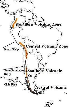
The Andean Volcanic Belt is segmented into four main areas of active volcanism; the Northern, Central, Southern and Austral volcanic zones, each of which is a separate continental volcanic arc.
Northern Volcanic Zone
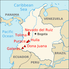
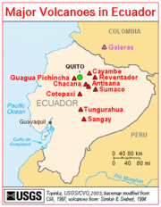
The Northern Volcanic Zone (NVZ) extends from Colombia to Ecuador and includes all volcanoes on the continental mainland of these countries. Of the zone's volcanoes, 55 are located in Ecuador while 19 are in Colombia. In Ecuador the volcanoes are located in the Cordillera Occidental and Cordillera Real while in Colombia they are located in Cordillera Central. The volcanic arc has formed due to subduction of the Nazca Plate under western South America. Some volcanoes of the Northern Volcanic Zone, such as Galeras and Nevado del Ruiz that lie in densely populated highland areas, are major sources of hazards. It has been estimated that crustal thickness beneath this region varies from around 40 to perhaps more than 55 km.[2] Sangay is the southernmost volcano of the Northern Volcanic Zone.
The Geophysics Institute at the National Polytechnic School in Quito, Ecuador houses an international team of seismologists and volcanologists [3] whose responsibility is to monitor Ecuador's numerous active volcanoes in the Andean Volcanic Belt and the Galápagos Islands, all of which is part of the Ring of Fire.
Central Volcanic Zone
The Central Volcanic Zone (CVZ) is a volcanic arc in western South America. It is one of the four volcanic zones of the Andes. The Central Volcanic Zone extends from Peru to Chile and forms the western boundary of the Altiplano plateau. The volcanic arc has formed due to subduction of the Nazca Plate under western South America along the Peru–Chile Trench. To the south the CVZ is limited by the Pampean flat-slab segment or Norte Chico flat-slab segment, a region devoid of volcanism due to a lower subduction angle caused by the subduction of Juan Fernández Ridge.
The CVZ is characterized by a continental crust that reaches a thickness of approximately 70 km.[2] Within this zone there are 44 major and 18 minor volcanic centers that are considered to be active.[2] This volcanic zone also contains not less than six potentially active large silicic volcanic systems, which include those of the Altiplano-Puna Volcanic Complex, as are Cerro Panizos, Pastos Grandes, Cerro Guacha and La Pacana. Other silicic systems are Los Frailes ignimbrite plateau in Bolivia, and the caldera complexes of Incapillo and Cerro Galán in Argentina.[2][4][5]
Southern Volcanic Zone
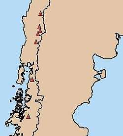
The South Volcanic Zone (SVZ) extends roughly from Central Chile's Andes at the latitude of Santiago, at ca. 33°S, to Cerro Arenales in Aysén Region at ca. 46°S, a distance of well over 870 mi (1,400 km). The arc has formed due to subduction of the Nazca Plate under the South American Plate along the Peru–Chile Trench. The northern boundary of the SVZ is marked by the flat-slab subduction of the Juan Fernández Ridge, which is believed to have produced a volcanic gap called the Pampean flat-slab segment in the Norte Chico region since the late Miocene. The southern end of the SVZ is marked by the Chile Triple Junction where the Chile Rise subducts under South America at the Taitao Peninsula giving origin to the Patagonian Volcanic Gap. Further south lies the Austral Volcanic Zone.
During the Pliocene the SVZ south of 38°S consisted of a broad volcanic arc. The area with volcanic activity 1 to 2 million years ago between 39°S-42°S was up to 300 km wide (if back-arc volcanism is included).[6] A reduction in the convergence rate of the Nazca and the South American Plate from 9 cm per year to 7.9 cm[6] per year 2-3 million years ago contributed to a narrowing of the southern SVZ that occurred possibly 1.6 million years ago.[7] The southern part of the SVZ retained vigorous activity only in the west, especially around the Liquiñe-Ofqui Fault Zone,[7] while eastern volcanoes such as Tronador and Cerro Pantoja became extinct.
Several volcanoes of the SVZ are being monitored by the Southern Andean Volcano Observatory (OVDAS) based in Temuco. The volcanoes monitored have varied over time but some like Villarrica and Llaima are monitored constantly. In recent years, there have been major eruptions at Chaitén (2008–2010), Cordón Caulle (2011) and Calbuco (2015).
Austral Volcanic Zone
The Austral Volcanic Zone (AVZ) is a volcanic arc in the Andes of southwestern South America. It is one of the four volcanic zones of the Andes. The AVZ extends south of the Patagonian Volcanic Gap to Tierra del Fuego archipelago, a distance of well over 600 mi (1,000 km). The arc has formed due to subduction of the Antarctic Plate under the South American Plate. Eruption products consist chiefly of alkaline basalt and basanite.[8] Volcanism in the Austral Volcanic Zone is less vigorous than in the Southern Volcanic Zone. Recorded eruptions are rare due to the area being unexplored well into the 19th century; the cloudy weather of its western coast might also have prevented sightings of eruptions. The Austral Volcanic Zone hosts both glaciated stratovolcanoes as well as subglacial volcanoes under the Southern Patagonian Ice Field.
Volcanic gaps
The different volcanic zones are intercalated by volcanic gaps, zones that, despite lying at the right distance from an oceanic trench, lack volcanic activity.[9] The Andes has three major volcanic gaps the Peruvian flat-slab segment (3 °S—15 °S), the Pampean flat-slab segment (27 °S—33 °S) and the Patagonian Volcanic Gap (46 °S—49 °S). The first one separates the Northern from the Central Volcanic Zone, the second the Central from the Southern and the last separates the Southern from the Austral Volcanic Zone. The Peruvian and Pampean gaps coincide with "flat slab" (low angle) subduction areas and therefore the lack of volcanism is believed to be caused by the shallow dip of the subducting Nazca Plate in these places. The shallow dip has in turn been explained by the subduction of the Nazca Ridge and the Juan Fernández Ridge for the Peruvian and Pampean gaps respectively. Since the Nazca and Juan Fernández Ridge are created by volcanic activity in Pacific hotspots (Easter and Juan Fernández) it can be said that volcanic activity in the Pacific is responsible for the suppression of volcanism in parts of the Andes.
The Patagonian gap is different in nature as it is caused not by the subduction of an aseismic ridge but by the subduction of the Chile Rise, the boundary ridge between the Nazca and the Antarctic Plate.[10]
Peruvian gap
Between the latitudes of 3 °S—15 °S in Peru the last volcanic activity occurred 2.7 million years ago in Cordillera Blanca.[11] The lack of volcanism in central and northern Peru is widely attributed to a side effect of the flat-slab (low angle) subduction of the Nazca Plate occurring there. While the subduction of the Nazca Ridge has often been credited for causing this flat-slab and hence the lack of volcanism, many researchers find the gap too wide to be explained by this alone.
One hypothesis claims that the flat-slab is caused by the ongoing subduction of an oceanic plateau. This hypothetical plateau named Inca Plateau would be a mirror image of the Marquesas Plateau in the South Pacific.[11]
Pampean gap
The Pampean gap or Norte Chico separates the Andes Central and Southern volcanic zones. A low subduction angle caused by the subduction of Juan Fernández Ridge has been pointed out as causing or contributing to the suppression of volcanism.
Back-arc volcanism
Back-arc volcanism is a significant phenomenon in Argentine Patagonia and Mendoza Province. Flat-slab subduction along the Peru–Chile Trench during the Miocene has been pointed out as being responsible for back-arc volcanism in Mendoza and Neuquén Province during the Quaternary.[12] Notable back-arc volcanoes include Payun Matru, Agua Poca, Payun Liso, Pali-Aike Volcanic Field, Tromen, Cochiquito Volcanic Group and Puesto Cortaderas.
Other significant back-arc volcanism regions include the Argentine Northwest where the Galán Caldera is located and the Andean foothills of Ecuador's Cordillera Real, where a series of alkaline volcanoes like Sumaco develops.[2]
Geothermal activity
The Andean Volcanic Belt represents a large geothermal province, with numerous hot springs, solfataras and geysers associated with its volcanoes. The geothermal exploration in the Andes was pioneered in Chile in the 1960s,[13] although the site of El Tatio was investigated previously in the 1920s. Compared to neighboring Central America, the Andean region is poorly explored and exploited for geothermal resources.
See also
- List of volcanoes in Argentina
- List of volcanoes in Bolivia
- List of volcanoes in Chile
- List of volcanoes in Colombia
- List of volcanoes in Ecuador
- List of volcanoes in Peru
References
- ↑ "Romeral". Volcano.si.edu. 29 March 2012. Global Volcanism Program
- 1 2 3 4 5 Stern, Charles R (December 2004). "Active Andean volcanism: its geologic and tectonic setting". Revista Geológica de Chile. [online]. 31 (2): 161–206. doi:10.4067/S0716-02082004000200001. ISSN 0716-0208. Retrieved 2008-11-20.
- ↑ "Home - Instituto Geofísico - EPN". igepn.edu.ec. Retrieved 11 September 2015.
- ↑ Ort, M.H. (1993). "Eruptive processes and caldera formation in a nested downsag collapse caldera: Cerro Panizos, central Andes mountains". J. Volcanol. Geotherm. Res. 56 (3): 221–252. Bibcode:1993JVGR...56..221O. doi:10.1016/0377-0273(93)90018-M.
- ↑ de Silva, S.L.; Francis, P.W. (1991). Volcanoes of the Central Andes. Berlin Heildelberg New York: Springer. p. 216.
- 1 2 Lara, L.; Rodríguez, C.; Moreno, H.; Pérez de Arce, C. (2001). "Geocronología K-Ar y geoquímica del volcanismo plioceno superior-pleistoceno de los Andes del sur (39-42°S)" [K-Ar geochronology and geochemistry of Upper Pleistocene to Pliocene volcanism of the southern Andes (39-42°S)]. Revista geológica de Chile (in Spanish). 28 (1): 67–90. doi:10.4067/S0716-02082001000100004.
- 1 2 Lara, L. E.; Folguera, A. (2006). "The Pliocene to Quaternary narrowing of the Southern Andean volcanic arc between 37° and 41°S latitude". GSA Special Papers. 407: 299–315. doi:10.1130/2006.2407(14).
- ↑ D'Orazio, M.; Agostini, S.; Mazzarini, F.; Innocenti, F.; Manetti, P.; Haller, M. J.; Lahsen, A. (2000). "The Pali Aike Volcanic Field, Patagonia: slab-window magmatism near the tip of South America". Tectonophysics. 321 (4): 407–427. doi:10.1016/S0040-1951(00)00082-2.
- ↑ Nur, A.; Ben-Avraham, Z. (1983). "Volcanic gaps due to oblique consumption of aseismic ridges". Tectonophysics. 99 (2-4): 355–362. doi:10.1016/0040-1951(83)90112-9.
- ↑ Russo, R. M.; Vandecar, J. C.; Comte, D.; Mocanu, V. I.; Gallego, A.; Murdie, R. E. (2010). "Subduction of the Chile Ridge: Upper mantle structure and flow". GSA Today. 20 (9): 4–10. doi:10.1130/GSATG61A.1.
- 1 2 Gutscher, M.-A.; Olivet, J.-L.; Aslanian, D.; Eissen, J.-P.; Maury, R. (1999). "The "lost inca plateau": cause of flat subduction beneath peru?". Earth and Planetary Science Letters. 171 (3): 335–341. doi:10.1016/S0012-821X(99)00153-3.
- ↑ Germa, A.; Quidelleur, X.; Gillot, P. Y.; Tchilinguirian, P. (2010). "Volcanic evolution of the back-arc Pleistocene Payun Matru volcanic field (Argentina)". Journal of South American Earth Sciences. 29 (3): 717–730. doi:10.1016/j.jsames.2010.01.002.
- ↑ "Andean Volcanic Belt". 5 November 1997. Retrieved 2009-07-19.
Further reading
- Pali Aike National Park (2008) http://www.letsgochile.com/locations/Southern-Patagonia/Pali-Aike-National-Park/
- UNESCO (1998) Submittal for inscription: Pali Aike and Fell Cave sites http://whc.unesco.org/en/tentativelists/1204/
- Stern, C. R. (2004). "Active Andean volcanism: its geologic and tectonic setting". Revista geológica de Chile. 31 (2): 161–206. doi:10.4067/S0716-02082004000200001.
External links
- B and 11B behaviour in the Northern Volcanic Zone of the Andes. Insights on the devolatilization of the slab and related magma genesis processes.
- OVDAS website