Langlois, Oregon
| Langlois, Oregon | |
|---|---|
| Census-designated place | |
|
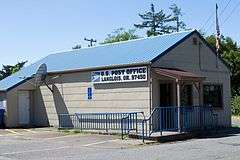
Langlois post office | |
 Langlois  Langlois Location within the state of Oregon | |
| Coordinates: 42°55′25″N 124°27′0″W / 42.92361°N 124.45000°WCoordinates: 42°55′25″N 124°27′0″W / 42.92361°N 124.45000°W | |
| Country | United States |
| State | Oregon |
| County | Curry |
| Area | |
| • Total | 1.42 sq mi (3.69 km2) |
| • Land | 1.42 sq mi (3.69 km2) |
| • Water | 0.0 sq mi (0.0 km2) |
| Elevation | 89 ft (27 m) |
| Population (2010) | |
| • Total | 177 |
| • Density | 124/sq mi (47.9/km2) |
| Time zone | Pacific (PST) (UTC-8) |
| • Summer (DST) | PDT (UTC-7) |
| ZIP code | 97450 |
| Area code(s) | 458 and 541 |
| FIPS code | 41-40950 |
| GNIS feature ID | 1122952 |
Langlois /ˈlæŋlᵻs/ is an unincorporated community and census-designated place in Curry County, Oregon, United States, on the Oregon Coast established in 1881. As of the 2010 census it had a population of 177.[1] Langlois was once famous for its blue cheese, until the cheese factory burned down in the 1950s. It was never rebuilt.
Langlois was named for William Langlois, an early Oregon pioneer. As phonetically spelled in the 1860 Federal Census, Port Oxford Precint [sic], page 110, the name was pronounced "Langless", as it is most commonly pronounced today by residents.[2][3]
Langlois is located spanning U.S. Route 101, 41 miles (66 km) by road north of Gold Beach. It is 2.3 miles (3.7 km) inland from the Pacific Ocean. Floras Creek, a tributary of the New River, passes through the southern part of the community.
References
- ↑ "Geographic Identifiers: 2010 Demographic Profile Data (G001): Langlois CDP, Oregon". U.S. Census Bureau, American Factfinder. Retrieved March 10, 2015.
- ↑ "Langlois". Our Oregon Coast. Retrieved 2014-12-18.
- ↑ "Langlois pronunciation: Welcome to World Famous Langlois Oregon". World Famous Langlois. Retrieved 2014-12-18.
External links
- Port Orford-Langlois School District
- Historic photos of Langlois from Salem Public Library
- Images of historic buildings in Langlois
- Langlois community website
Municipalities and communities of Curry County, Oregon, United States | ||
|---|---|---|
| Cities | 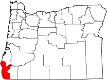 | |
| CDPs | ||
| Other unincorporated communities | ||