Lanester
| Lanester Lannarstêr | ||
|---|---|---|
|
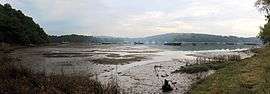
The ship graveyard on the Blavet river | ||
| ||
 Lanester | ||
|
Location within Brittany region  Lanester | ||
| Coordinates: 47°45′53″N 3°20′32″W / 47.7647°N 3.3422°WCoordinates: 47°45′53″N 3°20′32″W / 47.7647°N 3.3422°W | ||
| Country | France | |
| Region | Brittany | |
| Department | Morbihan | |
| Arrondissement | Lorient | |
| Canton | Lanester | |
| Intercommunality | Pays de Lorient | |
| Government | ||
| • Mayor (2008—2014) | Thérèse Thiery | |
| Area1 | 18.37 km2 (7.09 sq mi) | |
| Population (1999)2 | 21,897 | |
| • Density | 1,200/km2 (3,100/sq mi) | |
| Time zone | CET (UTC+1) | |
| • Summer (DST) | CEST (UTC+2) | |
| INSEE/Postal code | 56098 / 56600 | |
| Elevation | 0–51 m (0–167 ft) | |
|
1 French Land Register data, which excludes lakes, ponds, glaciers > 1 km² (0.386 sq mi or 247 acres) and river estuaries. 2 Population without double counting: residents of multiple communes (e.g., students and military personnel) only counted once. | ||

Lanester (Breton: Lannarstêr) is a commune in the Morbihan department in Brittany, in north-western France.
It is the largest suburb of the city of Lorient, across the river Scorff to the east.
Demographics
Inhabitants of Lanester are called Lanestériens.
Breton language
The municipality launched a linguistic plan through Ya d'ar brezhoneg on July the 13th of 2006.
In 2008, there was 5,67% of the children attended the bilingual schools in primary education.[1]
See also
References
- ↑ (French) Ofis ar Brezhoneg: Enseignement bilingue
External links
| Wikimedia Commons has media related to Lanester. |
- Official website (French)
- French Ministry of Culture list for Lanester (French)
- Map of Lanester on Michelin (English)
This article is issued from Wikipedia - version of the 6/22/2015. The text is available under the Creative Commons Attribution/Share Alike but additional terms may apply for the media files.