Lorient
| Lorient An Oriant | ||
|---|---|---|
|
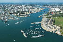
Aerial view of the harbour of Lorient | ||
| ||
 Lorient | ||
|
Location within Brittany region  Lorient | ||
| Coordinates: 47°45′N 3°22′W / 47.75°N 3.36°WCoordinates: 47°45′N 3°22′W / 47.75°N 3.36°W | ||
| Country | France | |
| Region | Brittany | |
| Department | Morbihan | |
| Arrondissement | Lorient | |
| Intercommunality | Pays de Lorient | |
| Government | ||
| • Mayor (2008–2014) | Norbert Métairie | |
| Area1 | 17.48 km2 (6.75 sq mi) | |
| Population (2007)2 | 58,135 | |
| • Density | 3,300/km2 (8,600/sq mi) | |
| Time zone | CET (UTC+1) | |
| • Summer (DST) | CEST (UTC+2) | |
| INSEE/Postal code | 56121 / 56100 | |
| Elevation | 0–46 m (0–151 ft) | |
|
1 French Land Register data, which excludes lakes, ponds, glaciers > 1 km² (0.386 sq mi or 247 acres) and river estuaries. 2 Population without double counting: residents of multiple communes (e.g., students and military personnel) only counted once. | ||
.svg.png)
Lorient (French pronunciation: [lɔ.ʁjɑ̃]; Breton: An Oriant) is a commune and a seaport in the Morbihan department in Brittany in north-western France.
History
Prehistory and classical antiquity
Beginning around 3000 BC, settlements in area of Lorient are attested by the presence of megalithic architecture. Ruins of Roman roads (linking Vannes to Quimper and Port-Louis to Carhaix) confirm Gallo-Roman presence.
Founding
In 1664, Jean-Baptiste Colbert founded the French East Indies Company.[1] In June 1666, an ordinance of Louis XIV granted lands of Port-Louis to the company, along with Faouédic on the other side of the roadstead. One of its directors, Denis Langlois, bought lands at the confluence of the Scorff and the Blavet rivers, and built slipways. At first, it only served as a subsidiary of Port-Louis, where offices and warehouses were located.[2] The following years, the operation was almost abandoned, but in 1675, during the Franco-Dutch War, the French East Indies Company scrapped its base in Le Havre since it was too exposed during wartime, and transferred its infrastructures to l'Enclot, out of which Lorient grew. The company then erected a chapel, workshops, forges, and offices, leaving Port-Louis permanently.[3]
The French Royal Navy opened a base there in 1690, under the command of Colbert de Seignelay, who inherited his father's position as Secretary of State of the Navy. At the same time, privateers from Saint-Malo took shelter there.[3] In 1700, the town grew out of l'Enclot following a law forcing people to leave the domain to move to the Faouédic heath. In 1702, there were about 6,000 inhabitants in Lorient, though activities slowed, and the town began to decline[4]
Growth under the Company of the Indies

The town experienced a period of growth when John Law formed the Perpetual Company of the Indies by absorbing other chartered companies (including the French East India Company), and chose Lorient as its operative base. Despite the economic bubble caused by the Company in 1720, the city was still growing[5] as it took part in the Atlantic triangular slave trade. From 1720 to 1790, 156 ships deported an estimated 43,000 slaves.[6] In 1732, the Company decided to transfer its sales headquarters from Nantes to Lorient, and asked architect Jacques Gabriel to raise new buildings out of dimension stones to host these new activities, and to embellish the L'Enclos domain.[5] Sales began in 1734, peaking up to 25 million livres tournois.[7] In 1769, the Company's monopoly ended with the scrapping of the company itself, under the influence of the physiocrats.[8]
Up until Company's closure, the city took advantage of its prosperity. In 1738, there were 14,000 inhabitants, or 20,000 considering the outlying villages of Kerentrech, Merville, La Perrière, Calvin, and Keryado, which are now neighbourhoods comprised in the present-day city limits. In 1735, new streets were laid down and in 1738, it was granted city status. Further work was undertaken as the streets began to be paved, wharfs and slipways were built along the Faouédic river, and thatched houses were replaced with stone buildings following 18th-century classical architecture style as it was the case for l'Enclos.[7] In 1744, the city walls were erected, and proved quickly useful as Lorient was raided in September 1746.[9] Following the demise of the Company, the city lost one-seventh of its population.[10]
In 1769, the city evolved into a full-scale naval base for the Royal Navy when the King bought out the Company's infrastructures for 17,500,000 livres tournois.[8] From 1775 on, the American revolutionary war brought a surge in activity, as many privateers hailed from Lorient. When the war ended, transatlantic lines opened to the United States, and in 1785, a new commercial company started under Calonne's tutelage (then Controller-General of Finances) with the same goal as the previous entities, i.e. conducting trade in India and China, with again Lorient standing as its operative base.[10]
The French Revolution and the subsequent Napoleonic wars put an end to trade for nearly two decades.[11]
19th century to the beginning of the 20th century

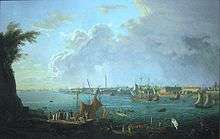
.jpg)
Maritime activities slowed at the start of the 19th century, the shipyards and the naval base reached a low that would last until the July Monarchy. During this period, the city was more of an administrative center.[12] The first secondary school opened in 1822, a lazaretto in 1823, and barracks in 1839.[13]
The city began to modernize in the second quarter of the century: in 1825, a roofed slipway and a drydock were added to the shipyards.[12] A sardine cannery[14] opened the same year. The first gasworks was built in 1845.[15]
In the second half of the 19th century, the steam engine allowed the ports to strengthen their output.[13] The first locomotive reached the city in 1865.[14] In 1861, the original drydock was enlarged as a second one was dug out. The same year, the ironclad Couronne was built on a design directly inspired by the Gloire class, though unlike her wooden-hull predecessors, she was entirely made of iron. She was followed in 1876 by the ironclad Redoutable, the first ship in the world with a steel structure.
In 1889, fishing expanded following the creation of the municipal fish market,[15] and the arrival of steam-powered fishing trawlers in 1900. The Keroman fishing port construction started in 1920.
World War II
In 1941, the Germans, then occupying France, chose to establish one of their U-boat headquarters in Keroman, a neighborhood of Lorient. But the submarines quickly became targets of constant bombing from Allied air forces. The Germans decided to build the largest U-boat base in Keroman, which would house the 2nd and the 10th U-boat flotillas for the bulk of the Battle of the Atlantic. Karl Dönitz, then supreme commander of the U-boat Arm, moved his staff in the Kernevel villa, just across the water from Keroman, in Larmor-Plage.
In 1943–1944, Lorient was nearly razed to the ground by Allied bombing, which failed to destroy the submarine pens, despite 4,000 tons of bombs dropped.[16] According to the book, "Steel Boats, Iron Hearts", by former U-505 crewman Hans Goebeler, after the allies failed to damage the U-Boat bunkers the bombing shifted to the city itself in order to deny the Germans workers and other resources. Before these bombings, thousands of leaflets were dropped on the population instructing the inhabitants to evacuate.[17]
On 10 May 1945, the German garrison surrendered. In 1949, the city of Lorient was awarded the Legion of Honour and the Croix de guerre 1939-1945.
Reconstruction

In April 1945, the Reconstruction Ministry advocated the use of temporary wooden shacks. These shelters were shipped as a kit to be built on site. In 1948, there were 28 settlements under the city's authority, and 20 more in the urban area, distributed among Ploemeur, Lanester, Hennebont and Quéven. Each of these neighbourhoods could hold up to 280 houses.
The transition period lasted from 10 to 40 years depending on the location. The last shack in the largest of them, Soye, was torn down in 1991. Today, only a few buildings dating back to the 18th century still stand.
Geography
Location
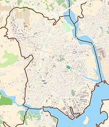
Lorient is located on the south coast of Brittany, where the Scorff river and the Blavet river join to form the roadstead of Lorient, before discharging into the Atlantic Ocean. To the south of the city, the Ter river used to flow into the estuary as well, but a dam was built in 1967, so it is now a pond. The city is 503 kilometres (313 mi) south-west of Paris, 153 kilometres (95 mi) south-west of Rennes and 158 kilometres (98 mi) north-west of Nantes.
The city comprises different neighbourhoods:
|
|
|
|
Adjacent towns:
 |
Quéven, Ploemeur |
Quéven, Caudan | Lanester | |
| Ploemeur | |
Lanester | ||
| ||||
| | ||||
| Ploemeur | Larmor-Plage, Port-Louis | Locmiquélic |
Climate
Under the Köppen climate classification, Lorient experiences an oceanic climate (Cfb), with mild winters and cool to warm summers. Precipitation is evenly distributed throughout the year. Frost is rare in winter, as are days over 30 °C (86 °F) during summer.
| Month | Jan | Feb | Mar | Apr | May | Jun | Jul | Aug | Sep | Oct | Nov | Dec | Year |
|---|---|---|---|---|---|---|---|---|---|---|---|---|---|
| Record high °C (°F) | 16.8 (62.2) |
17.6 (63.7) |
23.3 (73.9) |
27.1 (80.8) |
29.8 (85.6) |
35.9 (96.6) |
34.9 (94.8) |
37.5 (99.5) |
30.6 (87.1) |
27.2 (81) |
19.6 (67.3) |
16.4 (61.5) |
37.5 (99.5) |
| Average high °C (°F) | 9.5 (49.1) |
9.9 (49.8) |
12.3 (54.1) |
14.4 (57.9) |
17.7 (63.9) |
20.6 (69.1) |
22.5 (72.5) |
22.6 (72.7) |
20.5 (68.9) |
16.6 (61.9) |
12.6 (54.7) |
10.0 (50) |
15.8 (60.4) |
| Average low °C (°F) | 3.8 (38.8) |
3.4 (38.1) |
4.9 (40.8) |
6.1 (43) |
9.4 (48.9) |
11.7 (53.1) |
13.6 (56.5) |
13.4 (56.1) |
11.6 (52.9) |
9.5 (49.1) |
6.2 (43.2) |
4.1 (39.4) |
8.2 (46.8) |
| Record low °C (°F) | −13.1 (8.4) |
−11.0 (12.2) |
−7.4 (18.7) |
−4.1 (24.6) |
−1.1 (30) |
1.6 (34.9) |
3.4 (38.1) |
4.1 (39.4) |
1.0 (33.8) |
−1.8 (28.8) |
−5.0 (23) |
−8.7 (16.3) |
−13.1 (8.4) |
| Average precipitation mm (inches) | 108.3 (4.264) |
82.6 (3.252) |
72.9 (2.87) |
67.2 (2.646) |
74.6 (2.937) |
50.4 (1.984) |
56.0 (2.205) |
49.3 (1.941) |
70.5 (2.776) |
104.4 (4.11) |
103.0 (4.055) |
111.7 (4.398) |
950.9 (37.437) |
| Average precipitation days | 14.5 | 11.0 | 11.9 | 11.1 | 10.9 | 7.4 | 8.3 | 7.5 | 8.8 | 13.5 | 13.5 | 14.0 | 132.4 |
| Average relative humidity (%) | 88 | 85 | 82 | 79 | 81 | 80 | 80 | 81 | 84 | 87 | 87 | 88 | 83.5 |
| Mean monthly sunshine hours | 70.1 | 95.1 | 137.6 | 182.5 | 204.9 | 230.1 | 223.0 | 215.9 | 192.6 | 115.8 | 84.9 | 74.8 | 1,827.2 |
| Source #1: Météo France[18][19] | |||||||||||||
| Source #2: Infoclimat.fr (humidity, 1961–1990)[20] | |||||||||||||
Population
In 2009, Lorient had a population of 57,812.[21] In 2008, its intercommunality had 191,716 inhabitants.[22] Lorient is the most populous commune in Morbihan département, although the préfecture is the slightly smaller commune of Vannes.
Inhabitants of Lorient are called Lorientais.
| Historical population | ||
|---|---|---|
| Year | Pop. | ±% |
| 1793 | 22,318 | — |
| 1800 | 17,837 | −20.1% |
| 1806 | 20,553 | +15.2% |
| 1821 | 17,115 | −16.7% |
| 1831 | 18,322 | +7.1% |
| 1841 | 23,621 | +28.9% |
| 1851 | 25,694 | +8.8% |
| 1861 | 35,462 | +38.0% |
| 1872 | 34,660 | −2.3% |
| 1881 | 37,812 | +9.1% |
| 1891 | 42,116 | +11.4% |
| 1901 | 44,640 | +6.0% |
| 1911 | 49,039 | +9.9% |
| 1921 | 46,314 | −5.6% |
| 1931 | 42,853 | −7.5% |
| 1946 | 11,838 | −72.4% |
| 1954 | 47,095 | +297.8% |
| 1968 | 66,444 | +41.1% |
| 1975 | 69,769 | +5.0% |
| 1982 | 62,554 | −10.3% |
| 1990 | 59,271 | −5.2% |
| 1999 | 59,189 | −0.1% |
| 2009 | 57,812 | −2.3% |
| Sources: until 1962,[23] from 1968[24] | ||
Breton language
The municipality launched a linguistic plan through Ya d'ar brezhoneg on 25 January 2007.
In 2008, 2.71% of the children attended the bilingual schools in primary education.[25]
Economy

Ports
Lorient is commonly referred to as "the five port city" (military, fishing, commercial, passengers and yachting).[26] In 2010, the sector represented 9,600 direct jobs for a total 12,000 jobs (with indirect jobs accounted for), or 12% of local employment.[27]
- Keroman fishing port : In 2010, with a catch of 27,000 tons, it was second only to Boulogne-sur-Mer regarding catch tonnage among French fishing ports, but first considering the cash value.[28] It accounts for 3,000 jobs (including 700 fishermen) and 130 fishing vessels.
- Kergroise cargo port : With 2.6 million tons of cargo per year (including oil, cattle fodder, sand, containers), it ranks first in Brittany[29]
- Marinas : mooring berths are dispatched on Lorient (370), Kernevel (1,000), Port-Louis (450), Gâvres (57) and Guidel (102).[30] Additionally, there is a 800 metres (2,600 ft) long dock dedicated to offshore competitive sailing (Pôle course au large), recently built within the former Keroman submarine base.
- Passenger ships : each year, more 457,500 passengers set sail to the nearby islands of Groix and Belle-Île-en-Mer.
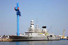
- Military : though no longer a French Navy base, new warships being built at DCNS temporarily dock on wharfs along the Scorff river.
_-_Port_et_rade_de_Lorient.jpg)
Industry
From its founding, shipbuilding has always been of great importance to the city. DCNS continues the legacy of the formerly state-owned shipyards (colloquially known as l'Arsenal) that began operation in 1690. It still builds warships, mainly frigates. There is also a substantial industrial base in Keroman to support the fishing fleet.
Transport
Lorient South Brittany Airport is situated just west of the city at Lann Bihoue, and it has direct flights to several destinations, such as to Paris and Lyon. There are direct connections with Ireland in Summer.
The Gare de Lorient is the railway station, offering connections to Quimper, Nantes, Rennes, Paris (slightly less than 4 hours by TGV) and several regional destinations.
Education
Schools in Lorient belong to the Academy of Rennes.
Tertiary
- CPGE at Dupuy-de-Lôme and Saint Joseph-La salle lycées.
- Université de Bretagne Sud.[31]
- Institut universitaire de technologie de Lorient
- École nationale supérieure d'ingénieurs de Bretagne sud[32]
- École supérieure d'art.[33]
- École nationale de musique et de danse.[34]
Military
Active units based near Lorient:
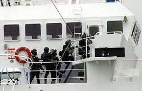
- Naval Commandos (Commando Marine): the special forces of the French Navy. Accordingly, it is one of the most selective units among the French armed forces, equivalent in their mission and affiliation to Navy SEALs or British Special Boat Service. Five out of the six existing naval commandos[35] are based in Lanester, just across the Scorff river from Lorient. The Naval Fusilier & Commando Training School is also based here.
- Lann-Bihoué Naval Aviation Base: Five flottilles are based in Ploemeur. Their tasks include airborne early warning, maritime patrol and air-sea rescue.
Keroman Submarine Base
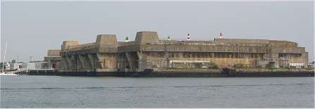
Lorient was the location of the Keroman Submarine Base. Grand Admiral Karl Dönitz decided to construct the base on 28 June 1940. Between February 1941 and January 1942 three gigantic reinforced concrete structures were built on the Keroman peninsula. They are called K1, K2 and K3. In 1944 work began on a fourth structure. The base was capable of sheltering thirty submarines. Lorient was damaged by Allied bombing raids but the naval base survived the war. Despite being surrounded by the U.S.Army, Lorient was held until May 1945 by the German army. The Germans refused to surrender because they could not destroy the base and its submarine pens, the Allies had decided to flatten the city and port of Lorient, to cut the supply lines to the U-boat bases. Between 14 January 1943 and 17 February 1943, as many as 500 high-explosive aerial bombs and more than 60,000 incendiary bombs were dropped on Lorient and the city was almost destroyed.
Culture
Events
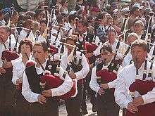
Each year in August since 1970, Lorient hosts the Festival interceltique, bringing together artists from all the Celtic world (Brittany, Cornwall, Scotland, Ireland, Wales, Galicia, Asturias, Australia, Acadia and Isle of Man). Each year, a Celtic nation is chosen as honored guest. It is one of the biggest festival in Europe by attendance (800,000 people for the 40th edition[36])
Media
Lorient is home to TyTélé, a local TV channel covering Morbihan through DTT.
Sports
Association football
The most popular club in Lorient is FC Lorient, which currently play in Ligue 1, the top level of French football. They are nicknamed les Merlus. They play their home fixtures at Stade du Moustoir. Christian Gourcuff has managed the team for over 20 years (aggregate years).
Sailing
The converted Keroman submarine base has been home port to several skippers and their sailing teams:
- Jérémie Beyou[37] (Delta Dore),
- Pascal Bidégorry[37] (Banque Populaire),
- Franck Cammas[37] (Groupama), winner of the 2011–12 Volvo Ocean Race
- Samantha Davies[37] (Roxy),
- Jean-Baptiste Dejeanty[37] (Maisonneuve),
- Jean-Pierre Dick[37] (Paprec-Virbac),
- Yann Elies[37] (Generali),
- Alain Gautier[37] (Foncia),
- Sébastien Josse[37] (British Telecom),
- Marc Thiercelin[37] (DCNS)
Lorient was also a staging port during the 2011–12 Volvo Ocean Race, as well as the starting point of la Solitaire du Figaro (2009 edition).
Eric Tabarly built three out of his six Pen Duick boats in Lorient.[38]
Notable Lorientais
Arts and literature
- Marie-Léontine Bordes-Pène (1858-1924), pianist
- Serge Danet, a.k.a. Soldat Louis, founding member of Soldat Louis.
- Renaud Detressan, b. 1956, a.k.a. Gary Wicknam, founding member of Soldat Louis
- Marie Dorval (1798-1849), actress
- Irène Frain, b. 1950, writer
- Ernest Hello (1828-1885), writer
- Viktor Lazlo, b. 1960, singer
- Julie Le Baud Bourdelle, b.1991, architect, tour guide and promising gardener
- Emmanuelle Le Cam, b. 1973, poet
- Claude Lepoitevin, b.1936, painter
- René Lote (1883-1944), writer and resistant
- Auguste Nayel (1845-1909), sculptor, first curator of the museum of Lorient and founding member of the Société lorientaise des Beaux-Arts.
- Émile Rocher, b. 1928, painter, sculptor and ceramist.
- Christian Tomine, b. 1958, writer
- Jacques Vaché (1895-1919), writer and artist, had a profound influence on Surrealism through his friendship with André Breton.
- Dylou, b. 1996, lead singer of "The Mondays"
Sailors
- Jean-Baptiste Bompard (1757–1842), took part in the American Revolutionary War as a privateer, later rose to the rank of admiral.
- François Joseph Bouvet (1753–1832), vice admiral and maritime prefect
- Jean-Baptiste Chaigneau (1769–1832), sailor, French consul in Cochinchina
- Pierre-François Forissier, b. 1951, admiral, Chief of Staff of the French Navy (2008–2011)
- Philippe Péché, b. 1961, navigator
- Alain Gautier, b. 1962, skipper
- Hervé Laurent, b. 1957, skipper
- Raymond Rallier du Baty (1881–1978), explorer of the Kerguelen islands.
Politics
- Henri Dupuy de Lôme (1816–1885), naval architect, chief designer of the Napoléon, La Gloire and Gymnote, which were breakthroughs in naval technology, also designed airships, deputy representing Morbihan, member of the Academy of Sciences, senator for life.
- Pierre-Paul Guieysse (1841–1914), Morbihan deputy, Minister of the Colonies.
- Albert Gortais (1914–1992) : resistant, took part in the liberation of Lorient, founding member of the MRP
- Louis Guiguen (1910–2011), résistant, Morbihan deputy
- Jean-Yves Le Drian, b. 1947, former mayor of Lorient, former Morbihan deputy, current Minister of Defence
- Jules Simon (1814–1896), philosopher, President of the Council of Ministers, senator for life, member of l'Académie française.
- Emmanuel Svob (1874–1946), mayor of Lorient
Sports
- Georges Eo, b. 1948, former football player and manager
- Christian Gourcuff, b. 1955, former manager of FC Lorient
- Yoann Gourcuff, b. 1986, son of the former, international midfielder, currently plays for Stade Rennais F.C.
- Ronan Le Crom, b. 1974, goalkeeper
- Jérémy Morel, b. 1984, left-back for Olympique de Marseille
Sciences
- Pierre Fatou (1878–1929), mathematician and astronomer
- Nicole Le Douarin, b. 1930, biologist
Others
- Jacques Andrieux (1917–2005), WWII fighter ace and Compagnon de la Libération.
- Jacques Stosskopf (1898–1944), naval engineer, résistant. Mistaken for being a traitor.
- Alphonse Tanguy (1896–1943), engineer, résistant, member of the Confrérie Notre-Dame.
International relations
Twin towns — Sister cities
L'Orient is twinned with:
 Galway, Ireland, since 1978[39]
 Vigo, Spain
 Wirral, United Kingdom[40]
 Ventspils, Latvia
 Toluca, Mexico
 Ludwigshafen, Germany
 České Budějovice, Czech Republic
 Denizli, Turkey
See also
- Mississippi Company
- U-74
- FC Lorient
- Festival Interceltique de Lorient
- Arrondissement of Lorient
- Communes of the Morbihan department
- Raid on Lorient (1746)
References
- Notes
- ↑ Chaumeil, Louis (1939). Abrégé d'histoire de Lorient de la fondation (1666) à nos jours (1939) (in French). p. 66.
- ↑ Chaumeil, Louis (1939). Abrégé d'histoire de Lorient de la fondation (1666) à nos jours (1939) (in French). p. 67.
- 1 2 Chaumeil, Louis (1939). Abrégé d'histoire de Lorient de la fondation (1666) à nos jours (1939) (in French). p. 68.
- ↑ Chaumeil, Louis (1939). Abrégé d'histoire de Lorient de la fondation (1666) à nos jours (1939) (in French). p. 69.
- 1 2 Chaumeil, Louis (1939). Abrégé d'histoire de Lorient de la fondation (1666) à nos jours (1939) (in French). p. 70.
- ↑ René Estienne, « Les archives des compagnies commerciales et la traite : l’exemple de la Compagnie des Indes », Service historique de la Défense, Lorient, janvier 2009
- 1 2 Chaumeil, Louis (1939). Abrégé d'histoire de Lorient de la fondation (1666) à nos jours (1939) (in French). p. 71.
- 1 2 Chaumeil, Louis (1939). Abrégé d'histoire de Lorient de la fondation (1666) à nos jours (1939) (in French). p. 73.
- ↑ Chaumeil, Louis (1939). Abrégé d'histoire de Lorient de la fondation (1666) à nos jours (1939) (in French). p. 72.
- 1 2 Chaumeil, Louis (1939). Abrégé d'histoire de Lorient de la fondation (1666) à nos jours (1939) (in French). p. 74.
- ↑ Chaumeil, Louis (1939). Abrégé d'histoire de Lorient de la fondation (1666) à nos jours (1939) (in French). p. 75.
- 1 2 Chaumeil, Louis (1939). Abrégé d'histoire de Lorient de la fondation (1666) à nos jours (1939) (in French). p. 76.
- 1 2 Chaumeil, Louis (1939). Abrégé d'histoire de Lorient de la fondation (1666) à nos jours (1939) (in French). p. 77.
- 1 2 Chaumeil, Louis (1939). Abrégé d'histoire de Lorient de la fondation (1666) à nos jours (1939) (in French). p. 80.
- 1 2 Chaumeil, Louis (1939). Abrégé d'histoire de Lorient de la fondation (1666) à nos jours (1939) (in French). p. 79.
- ↑ Lagarrigue, Max (2007). "Comment les Français vivent-ils les bombardements alliés?". Arkheia. Retrieved 21 March 2013.
- ↑ Hans, Goebeler (2008). Steel Boats, Iron Hearts. Savas Beatie LLC.
- ↑ "Données climatiques de la station de Lorient" (in French). Meteo France. Retrieved December 30, 2015.
- ↑ "Climat Bretagne" (in French). Meteo France. Retrieved December 30, 2015.
- ↑ "Normes et records 1961-1990: Lorient-Lann Bihoué (56) - altitude 42m" (in French). Infoclimat. Retrieved December 30, 2015.
- ↑ "INSEE". Retrieved 10 March 2013.
- ↑ "Lorient Agglo". Retrieved 10 March 2013.
- ↑ "EHESS". Retrieved 10 March 2013.
- ↑ "INSEE - Statistiques locales" (PDF). Retrieved 10 March 2013.
- ↑ (French) Ofis ar Brezhoneg: Enseignement bilingue
- ↑ "Lorient-ports". Retrieved 11 March 2013.
- ↑ Josse, Charles (25 March 2011). Ouest-France http://www.ouest-france.fr/actu/actuLocale_-a-Lorient-le-maritime-pese-12-000-emplois-_40875-1739514------56121-aud_actu.Htm. Retrieved 11 March 2013. Missing or empty
|title=(help) - ↑ Ouest-France. 7 January 2011 http://www.ouest-france.fr/actu/actuLocale_-26-000-tonnes-de-poisson-au-port-de-peche-de-Lorient_40811-1646705------56121-aud_actu.Htm. Retrieved 11 March 2013. Missing or empty
|title=(help) - ↑ "Lorient - Ports". Retrieved 11 March 2013.
- ↑ "Ports - Pays de Lorient". Retrieved 11 March 2013.
- ↑ Universite de Bretagne Sud
- ↑ École Nationale Supérieure d'Ingénieurs de Bretagne-Sud
- ↑ École Supérieure d'Art
- ↑ École Nationale de Musique et de Danse
- ↑ In the French Navy nomenclature, commandos are understood as units, not individuals
- ↑ Le Monde. 16 August 2010 http://www.lemonde.fr/festivals-de-l-ete/article/2010/08/16/record-d-affluence-au-festival-interceltique-de-lorient_1399242_1383721.html. Retrieved 25 March 2013. Missing or empty
|title=(help) - 1 2 3 4 5 6 7 8 9 10 "Voile news". Retrieved 25 March 2013.
- ↑ "Cité de la voile". Retrieved 25 March 2013.
- ↑ Galway City Council - Town Twinnings
- ↑ "British towns twinned with French towns". Archant Community Media Ltd. Retrieved 2013-07-11.
External links
| Wikimedia Commons has media related to Lorient. |
| Wikivoyage has a travel guide for Lorient. |
- Official website (in French)
- Ville de Lorient et Festival Interceltique Images
- Keroman submarine base
- Festival Interceltique de Lorient
- French Ministry of Culture list for Lorient (French)
- See pictures on Antonio Mucherino's web site
- Tourism office (in French)