Kotey Place, Wyoming
| Kotey Place, Wyoming | |
|---|---|
| Unincorporated community | |
 Kotey Place  Kotey Place | |
| Coordinates: 42°43′29″N 108°36′14″W / 42.72472°N 108.60389°W | |
| Country | United States |
| State | Wyoming |
| County | Fremont |
| Elevation[1] | 5,449 ft (1,661 m) |
| Time zone | Central (CST) (UTC-6) |
| • Summer (DST) | CDT (UTC-5) |
| Area code(s) | 307 |
| GNIS feature ID | 1597373[1] |
Kotey Place is an unincorporated community in Fremont County, Wyoming, United States.
Geography
Kotey Place is located at 42°43′29″N 108°36′14″W / 42.72472°N 108.60389°WCoordinates: 42°43′29″N 108°36′14″W / 42.72472°N 108.60389°W (42.724682, -108.604000).[1] It lies 5449 feet (1661 m) above sea level.
Kotey Place is located about 10 miles (16 km) southeast of the county seat Lander.[2]
References
- 1 2 3 U.S. Geological Survey Geographic Names Information System: Kotey Place, Wyoming. Retrieved on 2009-01-22.
- ↑ "Kotey Place, WY". HomeTownLocator.com. Retrieved on 2009-01-22.
Municipalities and communities of Fremont County, Wyoming, United States | ||
|---|---|---|
| Cities | 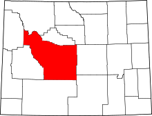 | |
| Towns | ||
| CDPs | ||
| Unincorporated communities | ||
| Ghost town | ||
| Indian reservation | ||
This article is issued from Wikipedia - version of the 10/25/2016. The text is available under the Creative Commons Attribution/Share Alike but additional terms may apply for the media files.