Knight Street
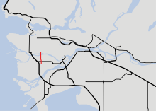 Knight Street's freeway portion highlighted in red. | |
| Maintained by | TransLink |
|---|---|
| Length | 4.7 km (2.9 mi) |
| Location | Vancouver, Richmond |
| North end |
SE Marine Drive (freeway) Clark Dr/12th Avenue (major road) in Vancouver |
| Major junctions | Highway 91 in Richmond |
| South end | Westminster Highway in Richmond |

Knight Street is a major north-south roadway in Vancouver and Richmond, British Columbia, Canada. It is a four-lane freeway from Westminster Highway in Richmond to Marine Drive in Vancouver, thus serving as an alternate way to exit Vancouver southbound, rather than the Granville Street/Oak Street corridor. Upon entering Vancouver, Knight Street provides major access routes to East Vancouver; at 14th Avenue, the road turns into Clark Drive, and runs northbound until it reaches the Port of Vancouver at Burrard Inlet. It is the busiest truck route in Vancouver,[1] and a key link between Vancouver and its neighbours to the south.
The freeway section of Knight Street crosses the Fraser River via the Knight Street Bridge, connecting Vancouver to Mitchell Island and Richmond. This is the only officially designated freeway in Metro Vancouver that is not also designated as a provincial highway. However, the whole length of Knight Street is part of TransLink's Major Road Network:[2] the agency owns the Knight Street Bridge,[3] and provides funding to the cities of Vancouver and Richmond for maintenance and major projects on the rest of the street.[1][4]
The street has become a favourite for street racers in the Vancouver area probably because of its long straight bridge, though the police presence has recently improved to thwart this activity.[5][6] The intersection of Knight Street and Southeast Marine Drive, at the northern end of Knight Street Bridge, ranked among the top ten motor-vehicle crash sites in all of British Columbia in 2008.[7]
The street (formerly known as Knight Road) was named after Robert Knight, a property owner in South Vancouver in the late 19th and early 20th centuries.[8]
Exit list
The entirety of this route is in Metro Vancouver.
| Location | km | mi | Destinations | Notes | |||
|---|---|---|---|---|---|---|---|
| City of Richmond | Westminster Highway | Southern terminus, at-grade | |||||
| Southbound exit, northbound entrance only | |||||||
| Jacombs Road | Southbound only | ||||||
| Bridgeport Road to Vancouver International Airport | |||||||
| Knight Street Bridge over Fraser River North Arm | |||||||
| Mitchell Road to Mitchell Island | |||||||
| | Knight Street Bridge over the Fraser River North Arm | ||||||
| City of Vancouver | SE Marine Drive | No northbound entrance from westbound Marine Drive | |||||
| Freeway ends and continues north as an arterial road | |||||||
1.000 mi = 1.609 km; 1.000 km = 0.621 mi
| |||||||
References
- 1 2 Clark-Knight Corridor Whole Route Analysis: Background and Issues, City of Vancouver, March 2003. Accessed online January 20, 2011.
- ↑ TransLink's Major Road Network, Highways and Gateways
- ↑ Knight St Bridge, TransLink
- ↑ TransLink 2010 Capital Program Cost-Sharing Submissions, City of Richmond, March 26, 2010. Accessed online January 20, 2011.
- ↑ Police turn radar guns on Knight Street, Vancouver Sun, April 4, 2006. Accessed online January 20, 2011.
- ↑ Vancouver police launch new speed-trap tactic, CTV British Columbia, June 5, 2008. Accessed online January 20, 2011.
- ↑ Accident-prone Metro home to all top 10 crash sites, Vancouver Sun, November 12, 2009. Accessed online January 20, 2011.
- ↑ Walker, Elizabeth (1999). Street Names of Vancouver. Vancouver Historical Society. p. 67. ISBN 0-9692378-7-1.
External links
- Clark-Knight Corridor Whole Route Analysis Project, City of Vancouver <--this link points to nowhere