British Columbia Highway 99A
| ||||
|---|---|---|---|---|
|
King George Boulevard McBride Boulevard 10th Avenue Kingsway Main Street Dunsmuir Street | ||||
| Route information | ||||
| Length: | 50 km (30 mi) | |||
| Existed: | 1942 – 2006 | |||
| Major junctions | ||||
| South end: |
| |||
|
| ||||
| North end: |
| |||
| Location | ||||
| Major cities: |
Surrey New Westminster Burnaby Vancouver | |||
| Highway system | ||||
|
British Columbia provincial highways
| ||||

Highway 99A was the designation of Highway 99's original 1942 alignment. It has had the '99A' designation between 1962 and 1964, and from 1973 to 2006 when it was decommissioned.
Route details
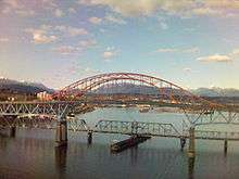
Highway 99A, with a total length of 50 km (31 mi), was a route within the Greater Vancouver area. The highway started in Surrey at the first exit off Highway 99 north of the Peace Arch. The stretch of Highway 99A through Surrey was known locally as the King George Highway. Originally to be named the Peace Arch Highway, it was dedicated officially on October 16, 1940 as the King George VI Highway after the royal visit of 1939. The highway served as a route for commuters travelling to New Westminster, Coquitlam, Burnaby and Vancouver. The highway goes north for 8 km (5.0 mi) to an interchange with Highway 99, and from there, another 4 km (2.5 mi) to its junction with Highway 10. The highway continued north for another 9 km (5.6 mi), where it merged with Highway 1A. Highways 1A and 99A continued northwest for 6 km (3.7 mi) to the Pattullo Bridge over the Fraser River, crossing from Surrey into New Westminster.
With the completion of the Pattullo Bridge in 1937 and the King George Highway in 1940, motorists were provided with a more efficient route between Vancouver-New Westminster and the U.S. border. Between 1942 and 1962, the King George Highway was designated Highway 99 while the Highway 99A designation was given to the older Pacific Highway after it became the alternate U.S. border route. The four-lane, divided "Deas (Island) Throughway" was completed to the U.S. border in 1962 and designated Highway 499 until 1973 when it was renamed Highway 99. At this time the King George Highway became Hwy. 99A. The old Pacific Highway became Hwy. 15 in 1958.
In 2009, the city of Surrey renamed "King George Highway" to "King George Boulevard".
In New Westminster, Highway 99A followed McBride Boulevard and 10th Avenue, then onto Kingsway, where the highway entered Burnaby. Highway 99A then proceeded west northwest for 6 km (3.7 mi) through the City of Burnaby to its intersection with Boundary Road, at which point the highway crossed into Vancouver.
In Vancouver, Highway 99A follows Kingsway northwest for 7 km (4.3 mi), then onto Main Street. Highway 99A followed Main Street north for 2 km (1.2 mi), then west onto the Dunsmuir Viaduct and Dunsmuir Street into the downtown core of the city to Burrard Street, where it reunites with Highway 99 on Georgia Street headed towards Stanley Park and the Lions Gate Bridge.
Exit list
The entirety of the route is in Metro Vancouver.
| Location | km | mi | Destinations | Notes | |||
|---|---|---|---|---|---|---|---|
| Becomes Georgia Street (Eastbound), Dunsmuir Street (Westbound) | |||||||
| Georgia and Dunsmuir Viaduct | |||||||
| Vancouver | Main Street | Eastbound exit only, highway exits to Main Street. On ramp from Main to Dunsmuir Viaduct to west. | |||||
| Becomes Main Street, Kingsway, 10th Avenue, McBride Boulevard | |||||||
| New Westminster | Royal Avenue | ||||||
| | Pattullo Bridge over the Fraser River, becomes King George Boulevard | ||||||
| Surrey | Scott Road | ||||||
| Colebrook Road | Right in, right out | ||||||
| Highway ends | |||||||
| 1.000 mi = 1.609 km; 1.000 km = 0.621 mi | |||||||