King, Ontario
| King | |
|---|---|
| Township (lower-tier) | |
| Township of King | |
 | |
 Location of King within York Region. | |
 King Location of King within York Region. | |
| Coordinates: 44°02′47″N 79°36′16″W / 44.04630°N 79.60440°WCoordinates: 44°02′47″N 79°36′16″W / 44.04630°N 79.60440°W | |
| Country |
|
| Province |
|
| Regional Municipality | York Region |
| Settled | 1800 |
| Incorporated | 1850 (township) |
| Government | |
| • Mayor | Steve Pellegrini |
| Area[1] | |
| • Total | 333.30 km2 (128.69 sq mi) |
| Population (2011)[1] | |
| • Total | 19,899 |
| • Density | 59.7/km2 (155/sq mi) |
| Time zone | EST (UTC-5) |
| • Summer (DST) | EDT (UTC-4) |
| Forward sortation area | L0G and L7B |
| Area code(s) | 905 and 289 |
| Website | www.king.ca |
King (2011 population 19,899)[2] is a township in York Region north of Toronto, within the Greater Toronto Area in Ontario, Canada.
The rolling hills of the Oak Ridges Moraine are the most prominent visible geographical feature of King. The Holland Marsh, considered to be Ontario's "vegetable basket",[3][4] straddles King Township and Bradford West Gwillimbury. King is known for its horse and cattle farms.
Though King is predominantly rural, most of its residents inhabit the communities of King City, Nobleton, and Schomberg.
History
Lieutenant-Governor John Graves Simcoe named King Township for John King (1759–1830),[5][6] an English Under-Secretary of State for Home Office from 1794 to 1801 for the Home Department in the Portland administration when Robert Jenkinson, 2nd Earl of Liverpool was Secretary of State.
The township was created as part of the subdivision of York County, itself a subdivision of the Home District. The lands were originally acquired by the British in an agreement with the Mississaugas, known as the Toronto Purchase; it was enacted in British parliament as the Toronto Purchase Act in 1787.[7] Acquisition of the lands for the townships of Etobicoke, King, Vaughan, and York, Upper Canada was completed at a meeting between the Mississaugas and the British at the Credit River on 1 August 1805, where 250,808 acres (1,014.98 km2) were exchanged for £1,700.[8]
Simcoe planned Yonge Street, which was built between 1793 and 1796 by the Queen's Rangers. By 1801, Timothy Rogers, a Loyalist from Vermont, had travelled the road and found an area on its western boundary immediately southwest of Newmarket very appealing. He applied for and received a grant for land totalling 40 farms, each of 200 acres (0.8 km2), and subsequently returned to Vermont to recruit families to operate those farms. By February 1802, he had set out for King Township with the first group of settlers for those forty farms. A second group followed later that month.
The area would become known as Armitage, in honour of its first settler Amos Armitage.[9] It was the first of King's settlements, and now part of Newmarket. Soon after the establishment of Armitage, the communities of Kettleby and Lloydtown were established to the west. More settlers arrived from New York, Pennsylvania, and other Loyalist enclaves over the subsequent years to populate the region, drawn by the abundant, fertile land being apportioned relatively cheaply to newcomers.
By 1842, the township consisted of 53,240 acres (215 km2) of land, of which 13,818 acres (56 km2) had been cleared and was being cultivated.[10] The principal villages at the time were Lloydtown, Brownsville (now Schomberg), Bogarttown (now a part of Newmarket), and Tyrwhitt's Mills (now Kettleby).[10]
In 1851, the township annexed from West Gwillimbury the portion of land north of its extant and east of the Holland River as a result of the formation of Simcoe County. Approximately 86,840 acres (351 km2) of land were administered by the township in 1878, according to the Historical Atlas of York County, but by 1973 this had been reduced to 82,000; some of its land has been ceded to what are now known as Newmarket, Aurora and Oak Ridges.
The first survey of King Township was conducted in 1800 by Hessian soldier Johann Stegmann.[5] At the time, the area's population was twenty residents. According to a letter by Benjamin Cody to the Newmarket Era published on 7 May 1892, there were church records listing births in the area, and the first white child in King may have been Sarah Rogers, born April 1800.[11] At least four children were born in King by July 1802.[11] By 1809, the township's population had increased sevenfold, to 160.[12] It wasn't until 1820, with the construction of roads into the township, that its population began to grow.[6] By 1842, the population of 2,625 residents was principally Irish, and also included those of English, Scottish, Canadian, and American descent.[10]
There is some evidence of a large Huron encampment at Hackett Lake. Residents in the area in the 1950s and 1960s discovered arrowheads and other archaeological items indicating a Huron presence. This is consistent with the fact that the Toronto Carrying-Place Trail, a major route used in the 17th and 18th centuries, passes through the township. The route was used by explorer Étienne Brûlé, who first travelled along the trail with twelve Huron guides in 1615.
Early settlements in the area developed primarily around gristmills and sawmills. These were important economic engines in the region during the 19th century, which resulted in the establishment of other communities and businesses nearby. By 1842, there were eight grist mills and 12 saw mills in King.[13] Some settlements have since been abandoned, or are no longer communities per se, including Bell's Lake, Davis Corners, and King Ridge.
In 1971, with the formation of the Regional Municipality of York and dissolution of York County, the township's boundaries were changed, shifting west by one concession from Yonge Street to Bathurst Street, and north by one lot from the King-Vaughan town line.
Geography

The township's boundaries are[14]
- East: Bathurst Street
- South: a line north of the King-Vaughan Road
- West: the Caledon/King Townline, which connects two roads (Caledon/King Townline North and Caledon/King Townline South) in a roughly straight line
- North: Highway 9 from the Caledon/King Townline to slightly east of Highway 27, then cuts north following branches of the Holland River until it meets Bathurst Street
The majority of King is located on the Oak Ridges Moraine, which is the origin for the headwaters of many rivers throughout its extent, including the Humber River in King. Numerous interconnected provincially and regionally significant areas are located in the township. The most prominent are seven Areas of Natural and Scientific Interest, and the wetland complexes adjacent to or within those areas.
Government

King Township was incorporated in 1850 as The Corporation of the Township of King. Its current mayor is Steve Pelligrini, who was sworn into office in December 2010. The Town Council includes the mayor and six councillors representing the township's six wards. The mayor is also a member of York Regional Council via double direct election.
| Position | Councillor | Communities represented |
|---|---|---|
| Mayor | Steve Pellegrini | All King Township |
| Ward 1 | Cleve Mortelliti | Eastern King City, Eversley, Snowball, Temperanceville |
| Ward 2 | Peter Grandilli | Nobleton, King Creek, Laskay, Strange |
| Ward 3 | Linda Pabst | Hammertown, Happy Valley, Holly Park, Linton, New Scotland |
| Ward 4 | Bill Cober | Schomberg, Pottageville, Lloydtown |
| Ward 5 | Debbie Schaeffer | Western King City, Heritage Park, Kettleby, Kinghorn |
| Ward 6 | Avia Eek | Ansnorveldt, Glenville and northeastern King Township |
2014 municipal election
In the 2014 municipal election, the mayorship was uncontested and Steve Pellegrini was acclaimed for a second term. Cleve Mortelliti was acclaimed for Ward 1 owing to no opposing candidates.[15] Candidates for the other wards were:[15]
- Ward 2: Joe Buscema, David Boyd, Peter Grandilli, and Jim Streb
- Ward 3: Linda Pabst and John Workman
- Ward 4: Greg Locke and Bill Cober
- Ward 5: Chris Gafoor, Anna Roberts, and Debbie Schaeffer
- Ward 6: Avia Eek and Simon Lloyd
The elected candidates were Steve Pelligrini (acclaimed, mayor), Cleve Mortelliti (acclaimed, ward 1), David Boyd (ward 2), Linda Pabst (ward 3), Bill Cober (ward 4), Debbie Schaeffer (ward 5), and Avia Eek (ward 6).[15]
Budget
The township draws revenues from various sources. The most significant in 2007 were municipal taxes (67.9% of revenue), fees and service charges (14.0%), water charges (4.3%), grants (3.5%) and reserves (2.9%). The most significant expenditures for 2007 are general municipal government (27.6%), recreation and culture (21.7%), transportation (17.8%), protection (16.6%) and environmental projects (11.6%).[16]
The Township offices reside at the King City Plaza, a strip mall purchased by the municipal government in the 1990s which also has several business tenants. In 2013, the township purchased the disused former Holy Name Catholic Elementary School building and adjacent 10 acres (40,000 m2) of land from the York Catholic District School Board for $2.95 million.[17] In 2016, township planning staff announced that the 360 square metres (3,900 sq ft) school building would be redesigned for use as office space for the township, for community and non-profit groups, and to house a satellite office for the York Regional Police.[18] In May 2016, the Police Services Board approved the King City substation and announced that a 20-year lease would be executed for use of about 280 square metres (3,000 sq ft) of space in the building.[19] In June 2016, township staff announced the building would be destroyed in mid-2016 and replaced by a 4,050 square metres (43,600 sq ft) structure on the site at a cost of about $15 million.[20] It will include a public-use gymnasium.[20] The capital project will be partially financed by selling the strip mall.[20]
Provincial and federal politics
As a result of the federal electoral redistribution of 2012, starting with the 2015 federal election the township is represented in the House of Commons by the Members of Parliament of the King—Vaughan and York—Simcoe electoral districts. The portion of King north of Highway 9 is part of the York—Simcoe electoral district, represented by Peter Van Loan of the Conservative Party of Canada. The remaining areas belong to King—Vaughan district and represented by Deb Schulte of Liberal Party of Canada. The federal riding of Oak Ridges—Markham was represented by Paul Calandra, a member of the Conservative Party of Canada. This riding was created for the 2004 election because of rapid growth in York Region.[21] Before 2004, King was in the riding of Vaughan—King—Aurora.
The provincial riding of Oak Ridges—Markham is currently represented by Helena Jaczek, a member of the Ontario Liberal Party.[22] It was created as part of Ontario's re-districting to match provincial electoral districts with their federal equivalents. King was part of the Vaughan—King—Aurora electoral district from 1999 to 2007, York—MacKenzie from 1995 to 1999, and York North from Confederation to 1995. The portion of King north of Highway 9 is part of the York—Simcoe electoral district, represented by Julia Munro of the Progressive Conservative Party of Ontario.
Demographics
Originally settled by United Empire Loyalists in the late 18th century, King is now influenced by the significant immigration and diversification resultant from its proximity to Toronto.
King Township's population grew by 2.1% between 2006 and 2011, most new residents settling in the communities of King City, Nobleton or Schomberg. The population density is 59.7 people per square kilometre; however, the Township is characterized by areas of extremely low density farming communities and the much higher density of its three major villages. In 2008, of the 19,640 residents in the township, 4,770 resided in King City, 3,100 in Nobleton, 1,970 in Schomberg, and 9,800 in other communities or rural areas.[23]
As of 2006, the median age of residents is 39.4; 30% of the population over 15 years of age is still single. Foreign-born residents accounted for 20% of the population. Only 3% of residents identify themselves as visible minorities.[24]
Of residents 15 years of age or older, 28% have a university certificate, diploma or degree. Another 18% have a college certificate or diploma, and 10% have a trade certificate or diploma. However, there is variability between age groups, as younger people are increasingly participating in higher levels of education.
Work
Nearly 15% of all employed residents work from home. Almost 3% walk or bike to work sites within the community; 5% use public transit, and 75% drive or are passengers in private vehicles, to reach work destinations within the Greater Toronto Area.
The participation rate in the work force is 72.4%, with a 3.6% unemployment rate. The largest industries are:[25]
- Construction and Manufacturing: 24%
- Business services: 23%
- Wholesale and Retail Trade: 17%
- Health and Education: 12%
- Finance and Real Estate: 8%
The median income for two-parent families is $90,364. For single-parent families, the median income is $43,673. The average value of a dwelling in King in 2006 was $386,416.
Religion
The township's residents have the following religious affiliation:
- 39.8% Protestant
- 38.3% Roman Catholic
- 17.1% atheist, agnostic or other non-theism
- 2.9% other Christian
- 0.1% Jewish
- 1.8% other religion
Language
According to the 2011 Census, the most prevalent mother tongues for King residents are as follows:[1]
Transportation
The Township of King is located between Toronto and Barrie, stretching from Bathurst Street to just east of Highway 50. King is accessible by Highways 400, 27, 9 and 11.
Public transportation is provided by York Region Transit (bus service) and GO Transit (bus and train services), but their services are limited in the township due to low population density. King City GO Station is the only train station in the township. York Region Transit's services are confined to the southeastern area, and GO bus serves the Nobleton and King City communities.
Most air travel is served by Toronto Pearson International Airport, Canada's largest airport, located south of the township in Mississauga. The township's only airport, King City Airport, was a general aviation airfield that closed in the 1990s.
Education
Public schools with classes from kindergarten through grade twelve are administered by the York Region District School Board and the York Catholic District School Board. The only public secondary school in King, King City Secondary School, serves students residing in a relatively large geographic area, including some from adjacent towns. A private Catholic high school, St. Thomas of Villanova College, and private JK -12 school, The Country Day School, are also located in the township.
Seneca College owns a campus located in the southeastern portion of King Township, where the College offers various programs.
Settlements
King's earliest settlement, Armitage, is now part of Newmarket. Its establishment was followed by those of Lloydtown and Kettleby. Subsequent settlements were founded near rivers, which provided the energy necessary to operate various mills. The earliest were based in Laskay, Kinghorn, and Eversley. The hamlet of Springhill was established later and flourished; it was renamed King City, now the largest community in the township.
- Eversley is a hamlet that, although it has its own historical development, has slowly been subsumed into King City. It lies on King City's north-eastern edge, south of Snowball. It was also known as Tinline's Corners in the 1800s.
- Glenville is a hamlet located in northeastern King, just south of the community of Ansnorveldt.
- Heritage Park is a community of King City. It is a natural and wildlife park characterized by ravines and creeks, some of which feed the East Humber River. Portions of the park are in the King City Trail.
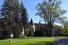
- Kinghorn is a community of King City, located at the Jane Street-King Road intersection. It is a sparse residential area adjacent to Highway 400, and is home to the King Township Museum and The Kingbridge Centre.
- Laskay is a hamlet located just west of King City and south of the King Road—Weston Road intersection.
- Snowball is a growing hamlet located just north of Eversley, west of Aurora.
Other hamlets in King include Holly Park, Linton, and New Scotland.
Heritage sites
In the township, there are eleven sites designated Heritage Sites, including:
- King Station was built in 1852 along the Northern Railway to serve Springhill (now King City). It was moved in 1989 to the grounds of the King Township Museum. It is believed to be the oldest surviving railway station in Canada, and was designated a heritage site in 1990.
- King Emmanuel Baptist Church, formerly the King Christian Church until 1931, it was moved to the grounds of the King Township Museum in 1982, and designated a heritage site in 1992.
- King City Cemetery, established in 1886, was designated a heritage site in July 2007.[26]
- King City Cemetery Dead House built circa 1887 was designated a heritage site in 2001. It is an octagonal structure that was used to preserve the dead during the winter, during which grave-digging was not feasible. Octagonal dead houses were unique to the area bordering Yonge Street north of Toronto during the late 19th and early 20th century.
- Eversley Presbyterian Church, a stone structure built in 1848, demonstrates the Scottish influence common in the area's early development. It was designated in 1984.
- Glenville Methodist Church, a small frame structure built in 1859, which remained operational until 1952. It was designated in 1983 as a township heritage site.
- King Christian Church Cemetery was the first burial grounds for Kettleby, built in 1850. It was designated a heritage site in 1986.
- Laskay Temperance Hall, built in 1859 by the Sons of Temperance. It had been operated by the Laskay Women's Institute since 1910, and is now operated by the municipality. It was designated a Heritage Site in 1986.
Public services

The township's municipal tax revenue is divided into three streams. One portion is combined with that from other municipalities for education purposes, a second portion is used to finance regional projects managed by York Region, and the last portion is used for local services.
The most significant cultural service provided via municipal funding is the King Township Public Library, which operates four branches in the township.
Waste management is provided through the region, and is co-ordinated with programs offered in other towns in York Region. Weekly green bin compost collection began in September 2007 to complement the weekly blue box collection of recyclable material; collection of all other waste was reduced to once every two weeks.[27] Water and wastewater management is operated by the township, though these services are not available ubiquitously; some areas rely on well water and septic tanks.
See also
Notes
- 1 2 3 Statistics Canada
- ↑ Statistics Canada
- ↑ Hyman 1954.
- ↑ York Region, Planning and Development Services Department.
- 1 2 Byers, Kennedy & McBurney 1976, p. 135.
- 1 2 Mathews 2015, p. 40.
- ↑ The Economist.
- ↑ Guillet 1969, p. 53.
- ↑ Carter 2011, p. 50.
- 1 2 3 Smith 1846, p. 90This is a 1970 reprint by Coles of the original 1846 work, part of the Coles Canadiana Collection.
- 1 2 Carter 2011, p. 62—63.
- ↑ King Township History and Heritage.
- ↑ Smith 1846, p. 91.
- ↑ Township of King: Map.
- 1 2 3 Township of King: 2014 Official Election Results.
- ↑ Township of King: 2007 Final Tax Bill.
- ↑ Pavilons 2013.
- ↑ Pavilons February 2016.
- ↑ Gismondi 2016.
- 1 2 3 Pavilons June 2016.
- ↑ Canadian Broadcasting Corporation 2010.
- ↑ Canadian Broadcasting Corporation 2007.
- ↑ King Township Business Times 2008.
- ↑ Statistics Canada: 2001 Census Community Profiles.
- ↑ Township of King: Employment by sector.
- ↑ Rea 2008.
- ↑ Township of King: Green Bin coming September 2007.
References
- Byers, Mary; Kennedy, Jan; McBurney, Margaret (1976). Rural Roots: Pre-Confederation Buildings of the York Region of Ontario. The Junior League of Toronto. Toronto: University of Toronto Press. ISBN 0802022308.
- Carter, Robert Terence (2011). Stories of Newmarket: An Old Ontario Town. Dundurn Press. ISBN 9781554888801.
- Gismondi, Angela (31 May 2016). "Police Services Board gives green light for new police station in King City". King Weekly Sentinel. Retrieved 24 June 2016.
- Hyman, Ralph (18 October 1954). "54 die; 69 lost". The Globe and Mail. Retrieved 13 April 2009.
- Mathews, Kelly (2015). Eaton Hall: Pride of King Township. Arcadia Publishing. ISBN 9781626199347.
- McClure Gillham, Elizabeth (1975). Early settlements of King Township, Ontario. King City, Ontario: The Hunter Rose Company. ISBN 0969049862.
- Guillet, Edwin C. (1969) [1933]. Pioneer Settlements in Upper Canada. University of Toronto Press. ISBN 0802061109.
- Pavilons, Mark (3 July 2013). "King Township purchases former Holy Name school for $2.95 M". King Weekly Sentinel. Retrieved 29 September 2013.
- Pavilons, Mark (3 February 2016). "Preparations being made for new King office property". King Weekly Sentinel. Retrieved 24 June 2016.
- Pavilons, Mark (8 June 2016). "King opts to build brand new municipal office". King Weekly Sentinel. Retrieved 24 June 2016.
- Rea, Bill. "King City Cemetery has its heritage designation". King Sentinel. Retrieved 15 February 2008.
- Smith, William H. (1846). Smith's Canadian Gazetteer. Toronto: H. & W. Roswell.
- "Toronto: Historical background". The Economist. Archived from the original on 7 August 2007. Retrieved 24 June 2006.
- "2014 Official Election Results". The Corporation of the Township of King. Retrieved 15 November 2014.
- "Regional results – DISTRICT: OAK RIDGES-MARKHAM". Ontario Votes 2007. Canadian Broadcasting Corporation. 11 October 2007. Retrieved 31 October 2007.
- "Oak Ridges-Markham". Canada Votes 2006. Canadian Broadcasting Corporation. 2006. Retrieved 28 September 2010.
- 2007 Final Tax Bill Information, Township of King, 2007
- "Employment by sector". King Township Demographics. Township of King. Archived from the original on 28 September 2007. Retrieved 31 October 2007.
- "Green Bin coming September 2007". Township of King. Archived from the original on 22 June 2007. Retrieved 6 August 2007.
- "Township of King" (PDF). Township of King. Archived from the original (PDF) on 7 February 2007.
- "Beth Underhill *Stables" (PDF). King Township Business Times. The Township of King. December 2008. Retrieved 9 November 2013.
- "King Township Heritage Map" (PDF). King Township History and Heritage. Archived from the original (PDF) on 28 September 2007. Retrieved 12 October 2007.
- "York Region Municipalities". York Region, Planning and Development Services Department. Retrieved 13 April 2009.
- "King, Ontario (Township)". 2001 Census Community Profiles. Statistics Canada. Retrieved 28 April 2006.
- "(Code 535) Focus on Geography". 2011 census. Statistics Canada. 2012.
- "(Code 3519049) Census Profile". 2011 census. Statistics Canada. 2012.
External links
| Wikimedia Commons has media related to King, Ontario. |
 |
New Tecumseth | Bradford West Gwillimbury | East Gwillimbury | |
| Caledon | |
Newmarket Aurora | ||
| ||||
| | ||||
| Vaughan | Richmond Hill |
King, Ontario | |
|---|---|
| Municipality | |
| Government | |
| Geography | |
| Education | |
| Culture | |
| Business and services | |
| Sport | |
| Transportation | |
| |
Largest city: Toronto | ||
| Regions | 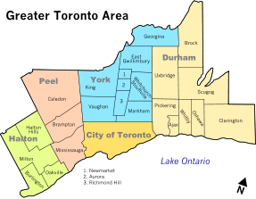 | |
| Cities | ||
| Towns | ||
| Townships and municipalities | ||