Schomberg, Ontario
| Schomberg | |
|---|---|
| Unincorporated community | |
| Coordinates: 44°00′12″N 79°41′06″W / 44.00333°N 79.68500°W | |
| Country | Canada |
| Province | Ontario |
| Regional Municipality | York Region |
| Township | King |
| Government | |
| • Township mayor | Steve Pellegrini |
| • MP | Deb Schulte |
| • MPP | Helena Jaczek |
| • Councillor | Bill Cober (Ward 4) |
| Area[1] | |
| • Land | 2.31 km2 (0.89 sq mi) |
| Elevation | 200 m (700 ft) |
| Population (2011)[2] | |
| • Total | 2,321 |
| • Density | 1,006.8/km2 (2,608/sq mi) |
| Demonym(s) | Schomberger or Schombergian |
| Time zone | EST (UTC-5) |
| • Summer (DST) | EDT (UTC-4) |
| Forward sortation area | L0G |
| Area code(s) | 905 and 289 |
| NTS Map | 031D04 |
| Website | www.schomberg.ca |
Schomberg (2011 population 2,321) is an unincorporated village in northwestern King, Ontario, Canada Situated north of the Oak Ridges Moraine and south of the Holland River, the village is surrounded by natural attractions.
Schomberg is accessed via Highway 9, which links Orangeville and Newmarket; via Highway 27 linking Barrie and Toronto; and the Lloydtown-Aurora Road. Its main street is York Regional Road 76, a graceful curved avenue separate from the local major highways.
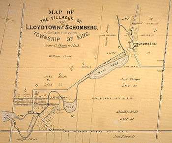
History
This area was occupied for thousands of years by varying indigenous cultures of First Nations peoples.
Founded by European Canadians as Brownsville, the history of Schomberg is that of a rural community. The name was likely for Meinhardt Schomberg, 3rd Duke of Schomberg, a general under King William III of England.[3] The urbanization was mainly in the southwestern part. The urban developments are small. In the 1950s and the 1960s, housing developments began near the centre, later, an industrial area popped up in the 1990s. The housing developments of Roselena Drive area began in the 1990s.
For some time in the early 20th century, the town was the terminus of the Schomberg and Aurora Railway that connected to the Toronto and York Radial Railway on Yonge Street, some distance to the east. The railway was constructed to bring shoppers and day-trippers from Toronto to the town, but was never very popular. Opened for traffic in 1902, it was electrified in 1916 and closed in 1927. The rails were removed the next year, but the right-of-way can still be seen to the east of town.
There are two active developments that will add 147 detached homes, 52 semi-detached homes, 29 townhouses, and a 127-unit six-storey condominium.[4]
Climate
Schomberg has a continental climate moderated by the Great Lakes and influenced by warm, moist air masses from the south, and cold, dry air from the north. The Oak Ridges Moraine affects levels of precipitation: as an air mass arrives from Lake Ontario and reaches the elevated ground surface of the moraine, it rises causing precipitation.[5]
| Climate data for Schomberg | |||||||||||||
|---|---|---|---|---|---|---|---|---|---|---|---|---|---|
| Month | Jan | Feb | Mar | Apr | May | Jun | Jul | Aug | Sep | Oct | Nov | Dec | Year |
| Record high °C (°F) | 13.0 (55.4) |
14.5 (58.1) |
24.0 (75.2) |
30.0 (86) |
32.5 (90.5) |
35.5 (95.9) |
36.0 (96.8) |
35.6 (96.1) |
33.0 (91.4) |
27.0 (80.6) |
24.0 (75.2) |
20.0 (68) |
36 (96.8) |
| Average high °C (°F) | −3.4 (25.9) |
−2.3 (27.9) |
3.1 (37.6) |
11.0 (51.8) |
18.5 (65.3) |
23.6 (74.5) |
26.3 (79.3) |
25.1 (77.2) |
20.1 (68.2) |
13.1 (55.6) |
6.0 (42.8) |
−0.4 (31.3) |
11.7 (53.1) |
| Average low °C (°F) | −11.4 (11.5) |
−10.6 (12.9) |
−5.5 (22.1) |
1.2 (34.2) |
6.4 (43.5) |
11.3 (52.3) |
13.9 (57) |
13.0 (55.4) |
9.0 (48.2) |
3.6 (38.5) |
−1.0 (30.2) |
−7.2 (19) |
1.9 (35.4) |
| Record low °C (°F) | −36.0 (−32.8) |
−33.0 (−27.4) |
−29.0 (−20.2) |
−14.0 (6.8) |
−4.0 (24.8) |
−2.0 (28.4) |
2.5 (36.5) |
0.5 (32.9) |
−6.5 (20.3) |
−8.9 (16) |
−22.0 (−7.6) |
−31.5 (−24.7) |
−36 (−32.8) |
| Average precipitation mm (inches) | 53.9 (2.122) |
44.4 (1.748) |
55.0 (2.165) |
62.8 (2.472) |
72.0 (2.835) |
75.1 (2.957) |
87.8 (3.457) |
88.6 (3.488) |
83.3 (3.28) |
68.3 (2.689) |
57.3 (2.256) |
25.4 (1) |
690.9 (27.201) |
| Source: Environment Canada[6] | |||||||||||||
Demographics
As of the Canada 2011 Census, Schomberg was home to 2,321 residents in 892 dwellings,[7] an increase in population of 38.2% from the 1,679 residents counted in the Canada 2006 Census.
Culture
An annual tradition is the Schomberg Fair, first held in 1851. It is an agricultural fair featuring a variety of events and activities. It is held every year on the last weekend in May.
A more recent annual tradition is Main Street Christmas. This is held one evening in December, during which people celebrate the holiday season by listening to carols, going on hay rides, and viewing ice sculptures, among other things.
Schomberg is home to the Schomberg Cougars, a Junior C hockey team playing in the Georgian Mid-Ontario Junior C Hockey League. The Schomberg Minor Hockey Association and the Schomberg Cougars are tenants of the Trisan Centre.
The largest inuksuk is located in Schomberg. It was built by a local stone quarry as an attraction for commerce.[8][9]
Education
Schomberg has two elementary schools: Schomberg Public School and St. Patrick's Catholic School. There is also a nursery school. There is no secondary school in Schomberg, so students generally attend King City Secondary School, Cardinal Carter Catholic High School, or St. Maximillian Kolbe Catholic High School.
Famous people
- NHL hockey players Adam Oates (1962-), Darryl Bootland (1981-), Mike Kitchen (1956-), Bill Kitchen (1960-2012)
- Police officer, Cam Woolley (1957-)
- Equestrians Eric Lamaze (1968-) and Beth Underhill (1962-)
Filming locations
- The 1970 Canadian film, Homer, starring Don Scardino and Ralph Endersby, was shot mainly in downtown Schomberg. In the film, the characters referred to the fictional town as "Schomberg, Wisconsin".
- Several other motion pictures have been shot in Schomberg and surrounding areas[10]
Nearby towns
 |
Beeton | Bond Head, Schomberg Heights | Bradford | |
| |
Pottageville, Kettleby, Newmarket | |||
| ||||
| | ||||
| Lloydtown, Palgrave | Nobleton | King City |
References
- "(Code 1357) Census Profile". 2011 census. Statistics Canada. 2012. Retrieved 2012-02-25.
- "Bradford Muck Research, Ontario". Canadian Climate Normals 1971-2000. Environment Canada. Retrieved 2012-02-29.
Notes
- ↑ Statistics Canada: 2012
- ↑ Statistics Canada: 2012
- ↑ "Schomberg". Rural Routes. Retrieved 13 May 2012.
- ↑ "Schomberg Developments". The Corporation of the Township of King. Retrieved 2012-04-16.
- ↑ Cf. Toronto and Region Conservation Authority, Rouge River Watershed Plan Report (2007), 15.
- ↑ Environment Canada
- ↑ Statistics Canada: 2012
- ↑ Large Canadian Roadside Attractions
- ↑ "The Biggest, the Smallest: World Records and 20 Minutes of Fame", 20 Minutes of Fame Blog, 7 Jan 2008
- ↑ IMDB Movie Database
External links
- Schomberg Community Profile at King Township website
- Map of Schomberg, ON (PDF)
- Dufferin Marsh
- Welcome to the Township of King (King Township official site)
King, Ontario | |
|---|---|
| Municipality | |
| Government | |
| Geography | |
| Education | |
| Culture | |
| Business and services | |
| Sport | |
| Transportation | |
| |
Coordinates: 44°00′12″N 79°41′06″W / 44.00333°N 79.68500°W