Killarney, Queensland
| Killarney Queensland | |||||||
|---|---|---|---|---|---|---|---|
 View of Killarney from the south | |||||||
 Killarney | |||||||
| Coordinates | 28°20′S 152°18′E / 28.333°S 152.300°ECoordinates: 28°20′S 152°18′E / 28.333°S 152.300°E | ||||||
| Population | 773 (2011 census)[1] | ||||||
| Established | 1878 | ||||||
| Postcode(s) | 4373 | ||||||
| Elevation | 507 m (1,663 ft) | ||||||
| LGA(s) | Southern Downs Region | ||||||
| State electorate(s) | Southern Downs | ||||||
| Federal Division(s) | Maranoa | ||||||
| |||||||


Killarney is a small town located 35 kilometres (22 mi) south-east of Warwick, on the Condamine River in Queensland, Australia. The town forms part of the Southern Downs local government area. Killarney is located about 8 kilometres (5.0 mi) from the Queensland/New South Wales border. It is close to Queen Mary Falls, in the Main Range National Park, where Spring Creek plunges 40 m into the valley. At the 2011 census, Killarney had a population of 773.[1]
The name of the town is said to be a result of the area's strong visual resemblance to that of Killarney in County Kerry, a region of south-western Ireland.
History
Originally part of Canning Downs, established by the Leslie brothers in 1840, the development of the town was largely based on primary production and forestry.
The South Killarney town site was first surveyed in 1878, but the town already boasted several shops and services by this time. Many early settlers to Queensland selected land in the Killarney area with the first of these arriving in 1863. During the 1880s Killarney was described as "one of the most flourishing towns in Southern Queensland".[2]
A branch railway was built from Warwick in 1885. The line closed in 1964.[3]
The first Killarney Post Office opened on 1 July 1877 (a receiving office had been open from 1875). Killarney North Post Office opened on 26 June 1889 (replacing Killarney North Railway Station receiving office open from 1887) and was renamed North Killarney in 1897. In 1905 the Killarney office was renamed Killarney South, and the North Killarney office became the second Killarney office, due to the town having moved to near the railway station.[4]
The town was hit by a destructive tornado on Saturday 23 November 1968, which destroyed many of the original buildings.[5] The main street buildings that survived the storm: the Butter Factory, the Co-op Building, MacKenzie’s Emporium (now a St Vincent de Paul boutique), former Commercial Bank (opposite the Post Office), the Post Office and the Killarney Hotel, hint at the town's former glory.[6] The former National bank building did survive the storm but was relocated to a suburb of Brisbane in 1977. The old Bank Vault foundation stones remain on the vacant block in the buildings original location adjacent to the St Vincent de Paul boutique. November 2008 marks the 40th anniversary of this storm.[7]
Buildings
The Killarney Co-operative is Killarney's main street under one roof. Partially operating in the original Milward's General Store, originally established in 1913 as the Killarney Dairy Company, the Co-operative was formed in 1922 and remains community owned. In 2008, the "Co-op" was a department store boasting in-store banking, gifts, shoes, electrical, hardware, garden, agricultural supplies, supermarket, delicatessen and coffee shop.
Several key buildings remain in Willow St. The Killarney Post Office was built in 1905. The CWA building, formerly the School of Arts, was built in 1888 on stilts over Gravel Creek and is testament to how crowded the main street had become at the towns height. The Killarney Hotel is located in Willow St and is the third hotel to sit on this site.[6]
The Killarney Recreation Club has been a recent addition to the townscape on the southern side of town, built with funds raised by the local community. Two sandstone horseheads at the entrance to the Polocrosse Fields and the "God of Sport Statue" in front of the Club were created by locally based sculptor Paul Stumkat.
Economy
The local economy is underpinned by agriculture, abattoirs (which was closed in February 2011),[8] transport and more recently tourism. The annual agricultural show, rodeos, various horse-related events and the annual Border Ranges Trail Ride are major events that attract substantial numbers of visitors to the town. Killarney has many active community and sporting groups including the Killarney Area Promotion Association and the Killarney Cutters RugbyLeague club.
Attractions
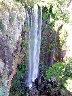
The five waterfalls surrounding Killarney make this area a popular scenic destination, the Teviot Falls, Queen Mary Falls, Dagg's Falls, Brown's Falls and Upper Brown's Falls. During wet weather there are two additional falls, Black Fella Falls and Jack Brunton's Falls, which can be seen tumbling down the cliffs surrounding Killarney at the bottom of the Cambanoora Gorge.
Climate
Killarney has a cool subtropical climate, like most of inland south-east Queensland. Winters can be cold and frosty, while summers are warm but rarely hot.
| Climate data for Killarney, Queensland | |||||||||||||
|---|---|---|---|---|---|---|---|---|---|---|---|---|---|
| Month | Jan | Feb | Mar | Apr | May | Jun | Jul | Aug | Sep | Oct | Nov | Dec | Year |
| Record high °C (°F) | 39.6 (103.3) |
39.3 (102.7) |
35.3 (95.5) |
33.1 (91.6) |
29.4 (84.9) |
24.3 (75.7) |
25.4 (77.7) |
30.0 (86) |
32.0 (89.6) |
36.0 (96.8) |
39.1 (102.4) |
38.9 (102) |
39.6 (103.3) |
| Average high °C (°F) | 29.4 (84.9) |
28.3 (82.9) |
26.8 (80.2) |
24.1 (75.4) |
20.5 (68.9) |
17.6 (63.7) |
17.0 (62.6) |
18.7 (65.7) |
21.9 (71.4) |
25.1 (77.2) |
27.7 (81.9) |
29.2 (84.6) |
23.9 (75) |
| Average low °C (°F) | 15.8 (60.4) |
15.9 (60.6) |
14.3 (57.7) |
10.2 (50.4) |
6.4 (43.5) |
3.5 (38.3) |
2.1 (35.8) |
2.7 (36.9) |
5.3 (41.5) |
9.1 (48.4) |
12.2 (54) |
14.3 (57.7) |
9.3 (48.7) |
| Record low °C (°F) | 9.4 (48.9) |
6.4 (43.5) |
3.3 (37.9) |
0.6 (33.1) |
−3.3 (26.1) |
−8.2 (17.2) |
−7.8 (18) |
−6.0 (21.2) |
−3.5 (25.7) |
−3.5 (25.7) |
2.8 (37) |
4.3 (39.7) |
−8.2 (17.2) |
| Average precipitation mm (inches) | 96.0 (3.78) |
87.7 (3.453) |
76.5 (3.012) |
46.4 (1.827) |
44.5 (1.752) |
45.4 (1.787) |
44.3 (1.744) |
31.6 (1.244) |
39.8 (1.567) |
64.0 (2.52) |
74.8 (2.945) |
92.9 (3.657) |
744.4 (29.307) |
| Average precipitation days | 9.6 | 9.8 | 9.8 | 7.4 | 7.4 | 7.0 | 6.3 | 5.5 | 5.6 | 7.5 | 8.3 | 9.5 | 93.7 |
| Source: Bureau of Meteorology[9] | |||||||||||||
Water supply
Water to the town is supplied from a small weir on Spring Creek. In April 2007, the Courier Mail newspaper reported that the town might have to be evacuated due to water shortages caused by years of extreme drought.[10] In January 2008 the Condamine River broke its banks after a week of steady rain and buildings in the main street were flooded.[11] Since that time Killarney has returned to the verdant green hills local long term residents find more familiar.[12]
Notable people
- Jackie Howe, champion shearer, born in Killarney
References
- 1 2 Australian Bureau of Statistics (31 October 2012). "Killarney (L) (Urban Centre/Locality)". 2011 Census QuickStats. Retrieved 29 October 2015.
- ↑ Killarney & District Historical Society, Memories of Killarney & District. Pg 7
- ↑ The Killarney Branch Line Armstrong, J. Australian Railway Historical Society Bulletin, August 1976 pp166-181
- ↑ Premier Postal History. "Post Office List". Premier Postal Auctions. Retrieved 10 May 2014.
- ↑ Oconnor, T (25 April 1998). "1968 The Year that Shook the World". The Courier-Mail. 2. p. 001.
- 1 2 Killarney & District Historical Society, Memories of Killarney & District.
- ↑ Peter Gunders (21 November 2008). "Killarney commemorates fortieth anniversary of tornado". ABC Southern Queensland.
- ↑ (10 February 2010) Jon Condon. Pittsworth, Killarney abattoirs close. Queensland Country Life. Fairfax Agricultural Media. Retrieved 3 August 2013.
- ↑ "Climate Statistics for Killarney, Queensland". Retrieved 14 April 2014.
- ↑ Towns face drought death blow by Tuck Thomspon. 26 April 2007. Retrieved on 28 April 2007.
- ↑ Floods bring relief to Killarney district by Amy Phillips Wednesday, 16 January 2008
- ↑ The silver lining to summer's storm clouds An ABC 7:30 report that highlights "Australia as the land of drought and flooding rains"