Johnson's Shut-Ins State Park
| Johnson's Shut-Ins State Park | |
| Missouri State Park | |
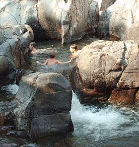 A portion of the park's natural water park pictured after the 2009 reopening | |
| Country | United States |
|---|---|
| State | Missouri |
| County | Reynolds |
| Elevation | 1,106 ft (337 m) [1] |
| Coordinates | 37°32′14″N 90°51′01″W / 37.53722°N 90.85028°WCoordinates: 37°32′14″N 90°51′01″W / 37.53722°N 90.85028°W [1] |
| Area | 8,646.51 acres (3,499 ha) [2] |
| Established | 1955 [3] |
| Management | Missouri Department of Natural Resources |
| - Visitors Center | Black River Center |
| - coordinates | 37°32′52″N 90°50′51″W / 37.54778°N 90.84750°W [4] |
| Visitation | 301,663 (2014) [5] |
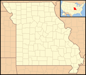 Location in Missouri | |
| Website: Johnson's Shut-Ins State Park | |
Johnson's Shut-Ins State Park is a state-owned, public recreation area covering 8,647 acres (3,499 ha) on the East Fork Black River in Reynolds County, Missouri. The state park is jointly administered with adjoining Taum Sauk Mountain State Park, and together the two parks cover 16,050 acres (6,500 ha) in the St. Francois Mountains region of the Missouri Ozarks.
The term "shut-in" refers to a place where the river's breadth is limited by hard rock that is resistant to erosion. In these shut-ins, the river cascades in many rivulets over and around igneous rocks worn smooth over many eons. It is used by park visitors as a natural water park when the water is not so high as to be dangerous.[6]
Geology
The bedrock of the area is an erosion resistant rhyolite porphyry and dark colored diabase dikes of Proterozoic age. Waters of the East Fork Black River became confined, or "shut-in," to a narrow channel following fractures and joints within the hard igneous rock. Water-borne sand and gravel cut deeply even into this erosion-resistant rock, carving potholes, chutes and canyon-like gorges.[7]
History
Most of the park, including the shut-ins and two miles of river frontage, was assembled over the course of 17 years and donated to the state in 1955 by Joseph Desloge[8] (1889–1971), a St. Louis civic leader and conservationist from the prominent Desloge lead mining family, which has continued over the years to donate funds for park improvements.
Disasters
On December 14, 2005, the park was devastated by a catastrophic flood caused by the failure of the Taum Sauk pumped storage plant reservoir atop a neighboring mountain. Damage included eradication of the park's campground, which was unoccupied at the time. The only people at the park were the park's superintendent and his family, who survived, sustaining some injuries.[9] The park was closed because of the extent of the damage it received.
The park partly reopened in the summer of 2006 for limited day use, but due to dangerous conditions, swimming in the river and exploring the rock formations was prohibited. In 2009, the river and shut-ins were reopened for water recreation. A new campground opened in 2010.[10] Park restoration and improvements are funded with $52 million of a $180 million settlement to the state from AmerenUE, the owner and operator of the failed reservoir.[11]
Some areas of forest in the park and the surrounding region were severely damaged by the May 2009 derecho windstorm. Straight-line wind speeds in this part of Reynolds County reached 60 to 70 mi/h (97 to 113 km/h) with microbursts estimated up to 100 mi/h (161 km/h).[12]
Activities and amenities
Camping, hiking, swimming, and rock climbing are available at the park.[6] A paved quarter-mile (0.4 km) walkway takes visitors to an observation deck overlooking the shut-ins.[13] A section of the Ozark trail also crosses the park, and the Goggins Mountain Equestrian Trail provides a 10-mile loop for those who bring their own horses.[14]
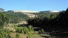
An extension to the park provides an auto tour that passes by the ongoing recovery effort, as well as the recovered endangered fens area,[8] terminating at a shaded overlook of the flood path accessible from the park entrance. From this one can walk a path through the boulder field created by the flood. The boulder field contains many examples of the minerals and rocks that make up the St. Francois Mountains of the Ozarks.[14][15]
References
- 1 2 "Johnson's Shut-Ins State Park". Geographic Names Information System. United States Geological Survey.
- ↑ "Missouri State Park Advisory Board Annual Report 2008". Missouri Department of Natural Resources. Retrieved August 17, 2015.
- ↑ "State Park Land Acquisition Summary". Missouri State Parks. Retrieved August 17, 2015.
- ↑ "Visitor Center - Black River Center". Missouri State Parks. Missouri Department of Natural Resources. Retrieved October 8, 2015.
- ↑ "Missouri State Park Attendance (2014)" (PDF). Missouri State Parks. 2015. Retrieved August 17, 2015.
- 1 2 "Johnson's Shut-Ins State Park". Missouri State Parks. Missouri Department of Natural Resources. Retrieved September 29, 2014.
- ↑ Beveridge, T. R., Geologic Wonders and Curiosities of Missouri, Missouri Department of Natural Resources, 2nd ed. 1990, pp 40–43
- 1 2 "General Information: Johnson's Shut-Ins State Park". Missouri State Parks. Missouri Department of Natural Resources. Retrieved August 17, 2015.
- ↑ "5 Years Later: Johnson's Shut-Ins". Missouri State Parks. Missouri Department of Natural Resources. Retrieved August 17, 2015.
- ↑ "Mo. set to reopen Johnson's Shut-Ins Park in May". The Southeast Missourian. Cape Girardeau, Mo. April 15, 2010. Retrieved April 15, 2010.
- ↑ "Gov. Nixon announces partial reopening of Johnson's Shut-Ins State Park on Saturday" (Press release). Office of Missouri Governor. June 5, 2009. Retrieved August 29, 2009.
- ↑ "May 8th 2009 Derecho". National Weather Service Weather Forecast Office St. Louis, MO. May 12, 2009. Archived from the original on May 17, 2009. Retrieved August 29, 2009.
- ↑ "Johnson's Shut-Ins State Park Accessibility Information" (PDF). Missouri State Parks. Missouri Department of Natural Resources. Retrieved August 17, 2015.
- 1 2 "Trails at Johnson's Shut-Ins State Park". Missouri State Parks. Missouri Department of Natural Resources. Retrieved August 17, 2015.
- ↑ "Scour Trail at Johnson's Shut-Ins State Park" (PDF). Missouri State Parks. Missouri Department of Natural Resources. Retrieved August 17, 2015.
External links
| Wikimedia Commons has media related to Johnson's Shut-Ins State Park. |
- Johnson's Shut-Ins State Park Missouri Department of Natural Resources