Jones-Confluence Point State Park
| Jones-Confluence Point State Park | |
| Missouri State Park | |
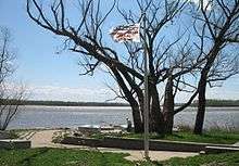
 Confluence Point with the Mississippi on the left and the Missouri on the right | |
| Country | United States |
|---|---|
| State | Missouri |
| County | St. Charles County |
| City | West Alton |
| Coordinates | 38°49′3″N 90°7′11″W / 38.81750°N 90.11972°WCoordinates: 38°49′3″N 90°7′11″W / 38.81750°N 90.11972°W |
| Area | 1,121.43 acres (454 ha) [1] |
| Established | 2001 [2] |
| Management | Missouri Department of Natural Resources |
 Location in Missouri | |
| Website: Jones-Confluence Point State Park | |
Edward "Ted" and Pat Jones-Confluence Point State Park is a state-owned, public recreation area in St. Charles County, Missouri, located on the north side of the Missouri River at its confluence with the Mississippi River.[3] The state park encompasses 1,121 acres (454 ha) of shoreline and bottomland and is managed by the Missouri Department of Natural Resources, which "plans to restore a natural floodplain reminiscent of what Lewis and Clark might have seen along the lower Missouri River."[4] The park is part of the Mississippi Greenway (formerly known as the Confluence Greenway)[5] and sits opposite the Columbia Bottom Conservation Area.
History
The Lewis and Clark Expedition began at the confluence in 1804, and the explorers returned there at the end of their journey.[4] Following the purchase of the site through the aid of a grant from the Danforth Foundation, the Western Rivers Conservancy conveyed the land to the Missouri Department of Natural Resources and the Metropolitan Parks and Recreation District in 2001.[6] The park opened May 9, 2004. It is named for Edward Jones Investments heir Edward D. "Ted" Jones and his wife Pat Jones, who donated $2.2 million for development of the Katy Trail.[4]
Activities and amenities
The area offers short trails, interpretive kiosks, and birdwatching.[4] Trails will eventually connect the park with the statewide Katy Trail.[7]
References
- ↑ "Missouri State Park Advisory Board Annual Report 2008". Missouri Department of Natural Resources. Retrieved August 17, 2015.
- ↑ "State Park Land Acquisition Summary". Missouri State Parks. Retrieved August 17, 2015.
- ↑ "Jones-Confluence Point State Park". Missouri State Parks. Missouri Department of Natural Resources. Retrieved September 29, 2014.
- 1 2 3 4 "General Information: Jones-Confluence Point State Park". Missouri State Parks. Missouri Department of Natural Resources. Retrieved September 29, 2014.
- ↑ "Confluence Greenway". Great Rivers Greenway. Retrieved September 29, 2014.
- ↑ "Missouri-Mississippi Confluence". Western Rivers Conservancy. Retrieved September 29, 2014.
- ↑ "Park Plans: Jones-Confluence Point State Park". Missouri State Parks. Missouri Department of Natural Resources. Retrieved October 8, 2015.
External links
| Wikimedia Commons has media related to Jones-Confluence Point State Park. |
- Jones-Confluence Point State Park Missouri Department of Natural Resources