Jefferson National Expansion Memorial
| Jefferson National Expansion Memorial | |
|---|---|
|
IUCN category V (protected landscape/seascape) | |
|
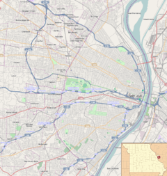
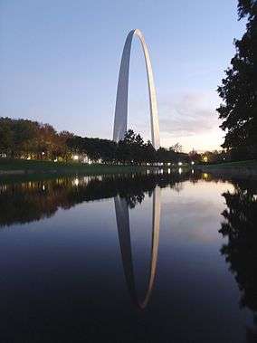
The Gateway Arch serves as the attraction's centerpiece. | |
| Location | St. Louis, Missouri, U.S. |
| Coordinates | 38°37′29″N 90°11′06″W / 38.62460°N 90.18497°WCoordinates: 38°37′29″N 90°11′06″W / 38.62460°N 90.18497°W |
| Area |
192.83 acres (78.04 ha) 90.96 acres (36.81 ha) federal |
| Established | December 21, 1935 |
| Visitors | 2,944,976 (in 2005) |
| Governing body | National Park Service |
| Website | |
|
Jefferson National Expansion Memorial | |
   | |
| Location | Mississippi River between Washington and Poplar Sts., St. Louis, Missouri |
| Area | 90.9 acres (36.8 ha) |
| Built | 1834 |
| NRHP Reference # | 66000941[1] |
| Added to NRHP | October 15, 1966 |
The Jefferson National Expansion Memorial is a park located in St. Louis, Missouri, near the starting point of the Lewis and Clark Expedition. It was designated as a National Memorial by Executive Order 7523, on December 21, 1935, and is maintained by the National Park Service (NPS).
The park was established to commemorate:
- The Louisiana Purchase, and the subsequent westward movement of American explorers and pioneers;
- The first civil government west of the Mississippi River; and
- The debate over slavery raised by the Dred Scott case.
The memorial consists of a 91-acre (36.8 ha) park along the Mississippi River on the site of the earliest buildings of St. Louis; the Old Courthouse, a former state and federal courthouse that saw the origins of the Dred Scott case; the 45,000 sq ft (4,200 m2) Museum of Westward Expansion; and most notably the Gateway Arch, a steel catenary arch that has become the definitive icon of the city.
Components
The Gateway Arch
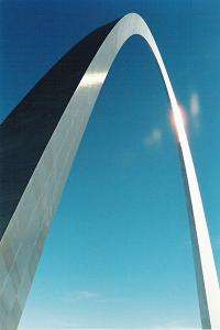
The Gateway Arch, known as the "Gateway to the West", is the tallest structure in Missouri. It was designed by Finnish-American architect Eero Saarinen and structural engineer Hannskarl Bandel in 1947 and built between 1963 and October 1965. It stands 630 feet (192 m) tall and 630 feet (192 m) wide at its base. The legs are 54 feet (16.5 m) wide at the base, narrowing to 17 feet (5.2 m) at the arch. There is a unique tram system to carry passengers to the observation room at the top of the arch.
Old Courthouse
The Old Courthouse is built on land originally deeded by St. Louis founder Auguste Chouteau. It marks the location over which the arch reaches. Its dome was built during the American Civil War and is similar to the dome on the United States Capitol which was also built during the Civil War. It was the site of the local trials in the Dred Scott case.
The courthouse is the only portion of the memorial west of Interstate 44. To the west of the Old Courthouse is a Greenway between Market and Chestnut Streets which is only interrupted by the Civil Courts Building which features a pyramid model of the Mausoleum of Mausolus (which was one of the Seven Wonders of the Ancient World) on its roof. When the Civil Courts building was built in the 1920s, the Chouteau family sued to regain the property belonging to the Old Courthouse because it had been deeded in perpetuity to be a courthouse.
Museum of Westward Expansion
Underneath the Arch is a visitor center, entered from a descending outdoor ramp starting at either base. Within the center is the Museum of Westward Expansion, exhibits on the history of the St. Louis riverfront, and tram loading and unloading areas. Tucker Theater, finished in 1968 and renovated 30 years later, has about 285 seats and shows a documentary (Monument to the Dream) on the Arch's construction. Odyssey Theater, designed by Cox/Croslin Architects, Robert Cox and Charles Croslin, was completed in 1993 and has 255 seats. It was the first 70 mm film theater to be located on National Park Service grounds and operated by the NPS. The theater runs films from a rotating play list. Also located in the visitor center are retail operations run by the Jefferson National Parks Association, a not-for-profit partner.
A bronze standing full-length portrait of Thomas Jefferson, done by A. Lloyd Lillie, a nationally renown sculptor, stands inside the entrance of the Museum. The casual pose represents the ease with which Jefferson was able to move seamlessly among his many interests and areas of expertise. He was a president, statesman, ambassador, architect, farmer, and a framer of the Declaration of Independence. The standing pose illustrates his tireless efforts for his young, developing, and independent country.
History

1930s
The memorial was developed largely through the efforts of St. Louis civic booster Luther Ely Smith who first pitched the idea in 1933, was the long-term chairman of the committee that selected the area and persuaded Franklin Roosevelt in 1935 to make it a national park after St. Louis passed a bond issue to begin building it, and who partially financed the 1947 architectural contest that selected the Arch.[2]
In the early 1930s the United States began looking for a suitable memorial for Thomas Jefferson (the Washington Monument and the newly built Lincoln Memorial were the only large Presidential memorials at the time).
Shortly after Thanksgiving in 1933 Smith who had been on the commission to build the George Rogers Clark National Historical Park in Indiana, was returning via train when he noticed the poor condition of the original platted location of St. Louis along the Mississippi. He thought that the memorial to Jefferson should be on the actual location that was symbolic of one of Jefferson's greatest triumphs—the Louisiana Purchase.
The originally platted area of St. Louis included:
- Site of the Spanish capital of Louisiana (New Spain) (basically the entire Louisiana Purchase area north of Louisiana from the city's founding in 1764 until it was turned .
- Site of the Battle of Saint Louis, the only battle west of the Mississippi River in the American Revolutionary War
- Site of the Three Flags Day ceremony in 1804 in which Spain turned over Louisiana to France for less than 24 hours before it was turned over to the United States clearing the way for Lewis and Clark to legally begin their exploration (which Spain had specifically prohibited)
- Site of the first capital of Upper Louisiana for the United States
Almost all of the historic buildings associated with this period had been replaced by newer buildings. His idea was to raze all of the buildings in the original St. Louis platted area and replace it with a park with "a central feature, a shaft, a building, an arch, or something which would symbolize American culture and civilization."
Smith pitched the idea to Bernard Dickmann who quickly assembled a meeting of St. Louis civic leaders on December 15, 1933 at the Jefferson Hotel and they endorsed the plan and Smith became chairman of what would become the Jefferson National Expansion Memorial Association (a position he would hold until 1949 with a one-year exception).
The Commission then defined the area, got cost estimates of $30 million to buy the land, clear the buildings and erect a park and monument. With promises from the federal government (via the United States Territorial Expansion Memorial Commission) to join if the City of St. Louis could raise money.
The area to be included in the park was bounded by the Eads Bridge/Washington Avenue on the north and Poplar Street on the south, the Mississippi River on the east and Third Street (now Interstate 44) on the west. The Old Courthouse, just west of Third Street, was added in 1940.
The only building in this area not included was the Old Cathedral, which is on the site of St. Louis first church and was opposite the home of St. Louis founder Auguste Chouteau. The founders of the city were buried in its graveyard (but were moved in 1849 to Bellefontaine Cemetery during a cholera outbreak).
Taking away 40 blocks in the center of St. Louis was bitterly fought by some sources—particularly the St. Louis Post-Dispatch.[3] On September 10, 1935, the voters of St. Louis approved a $7.5 million bond issue to buy the property.[4]
The buildings were bought for $7 million by the federal government via Eminent domain and was subject to considerable litigation but were ultimately bought at 131.99 percent of assessed valuation.[5] Roosevelt inspected the memorial area on October 14, 1936 during the dedication of the St. Louis Soldiers Memorial. Included in the party was then Senator Harry S. Truman.[6]
1940s
The land was to be cleared by 1942. Among the buildings razed was the "Old Rock House" 1818 home of fur trader Manuel Lisa (now occupied by the stairs on the north side of the Arch) and the 1819 home of original St. Louis pioneer Jean Pierre Chouteau at First and Washington.[7]
The architectural competition for a monument was delayed by World War II. Interest in the monument was fed after the war as it was to be the first big monument in the post-World War II era.
The estimated cost of the competition was $225,000 and Smith personally donated $40,000. Civic leaders held the nationwide competition in 1947 to select a design for the main portion of the Memorial space.
Architect Eero Saarinen won this competition with plans for a 590-foot (180 m) catenary arch to be placed on the banks of the Mississippi River. However, these plans were modified over the next 15 years, placing the arch on higher ground and adding 40 feet (12 m) in height and width.
The central architectural feature at the base of the arch is the Old Courthouse, which was once the tallest building in Missouri and has a dome similar to the United States Capitol and was placed on the building during the American Civil War at the same time as that on the U.S. Capitol.
Saarinen developed the shape with the help of architectural engineer Hannskarl Bandel. It is not a pure inverted catenary. Saarinen preferred a shape that was slightly elongated and thinner towards the top, a shape that produces a subtle soaring effect, and transfers more of the structure's weight downward rather than outward at the base.
When Saarinen won the competition, the official notification was sent to "E. Saarinen", thinking it to be the architect's father Eliel Saarinen, who had also submitted an entry. The family celebrated with a bottle of champagne, and two hours later an embarrassed official called to say the winner was, in fact, the younger Saarinen. The elder Saarinen then broke out a second bottle of champagne to celebrate his son's success.
Among the five finalists was local St. Louis architect Harris Armstrong.
1950s
Land for the memorial was formally dedicated on June 10, 1950 by Harry S. Truman. However the Korean War began and the project was put on hold.
On June 23, 1959, work begins on covering railroad tracks that cut across the memorial grounds.
1960s
On February 11, 1961, excavation began, and that September 1, Saarinen died. On February 12, 1963, the first stainless steel triangle that formed the first section of the arch was set in place on the south leg.
On October 28, 1965, it was completed, costing approximately $15 million to build. The adjacent park was designed by landscape architect Dan Kiley. Along with all other historical areas of the National Park Service, the memorial was listed on the National Register of Historic Places on October 15, 1966. Vice President Hubert Humphrey and Secretary of the Interior Stewart Udall dedicated the Arch on May 25, 1968.
1980s
In 1984, Congress authorized the enlargement of the Memorial to include up to 100 acres (40 ha) on the east bank of the Mississippi River in East St. Louis, Illinois. Funds were authorized to begin land acquisition, but Congress placed a moratorium upon NPS land acquisitions in fiscal year 1998. The moratorium continued into the 21st century, with expansion becoming less likely because of the construction of a riverboat gambling facility and related amenities.
1990s
During the Great Flood of 1993, Mississippi flood waters reached halfway up the Grand Staircase on the east.
In 1999, the Arch tram queue areas were renovated at a cost of about $2.2 million. As well, the Ulysses S. Grant National Historic Site in St. Louis County, Missouri, was put under the jurisdiction of the Superintendent of the Memorial.
2000s
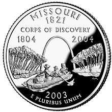
The arch was featured on the Missouri state quarter in 2003.
In 2007 St. Louis Mayor Francis Slay and former Missouri Senator John Danforth asked the National Park Service to create a more "active" use of the grounds of the memorial and model it on Millennium Park in Chicago including the possibility of an amphitheater, cafes and restaurants, fountains, bicycle rentals, sculptures and an aquarium.[8] The National Park Service was not in favor of the plan noting that the only other overt development pressure on National Park property has been at the Jackson Hole Airport in Grand Teton National Park[9]
2010s
For most of its life, the Memorial was largely separated from the rest of Downtown St. Louis by a sunken section of I-70 (now I-44 with the rerouting of I-70 over a new bridge), but in 2014 a lid was installed over the highway, creating the foundation for a park connecting downtown with the Memorial grounds. The NPS, as part of their Centennial Initiative celebrating its 100th anniversary in 2016, is considering a plan to complete Saarinen's original master plan. The intention is to build the Gateway Arch Connector to link the Old Courthouse with the grounds of the Arch.[10] In September 2010 Michael Van Valkenburgh Associates won a design contest to "re-envision the visitor experience" of the grounds.[11] The project, planned for 2015 to coincide with the 50th anniversary of the completion of the Arch, includes:[12]
- replacing the north garage with an amphitheater,
- new cobblestone plaza between the Arch and the river,
- elevated walkways on the Illinois side, reaching 35 feet and winding through a new bird sanctuary, (Congress has authorized purchase of the Illinois acreage)
- and covering I-70 (now I-44) and creating a new western entrance through an expanded museum below the Gateway Arch.
The renovation is now now scheduled for a December 2016 completion.[13]
In 2016, many ash trees on the grounds were removed to preemept damage from emerald ash borers.[14]
Additional photographs
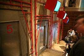 Lower south tram queue area
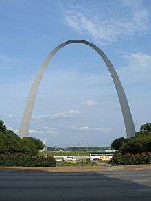 The Arch from the west, looking east over Luther Ely Smith Square
 The sign at the top of the observation deck.
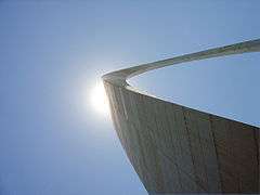 The St. Louis Arch as seen from the lawn.
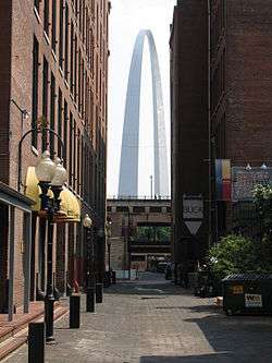 As seen from Laclede's Landing
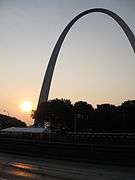 Arch at dawn
 The Old Cathedral as viewed from top of Arch
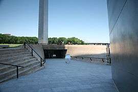 South entrance to the arch
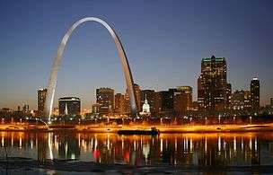 At night as seen from Illinois
 Gateway Arch from below
 Looking west from the observatory
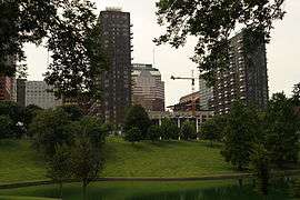
References
- ↑ National Park Service (2010-07-09). "National Register Information System". National Register of Historic Places. National Park Service.
- ↑ "Luther Ely Smith: Founder of a Memorial" (PDF). The Museum Gazette. National Park Service. Retrieved January 11, 2008.
- ↑ "Editorial". Jefferson City Daily Capital News. June 24, 1939.
- ↑ "St. Louis River Front Memorial Approved by Voters". The Southeast Missourian. 11 September 1935. Retrieved 10 November 2016.
An artist's conception of the proposed $30,000,000 Jefferson National Expansion Memorial on the waterfront at St. Louis. In the center of these plans suggest the Jefferson Memorial Building, which might include a museum of Jeffersonian and Missouri memoribilia [sic]. The long buildings to either side of the memorial structure have been suggested for separate museums for each of the states which eventualized from the Louisiana Purchase. A fountain to the right in the foreground would be in honor of the 13 original colonies, and one to the left to memorialize the Spanish cession. Obelisks at right and left extremes might be erected as monuments to the Santa Fe and Oregon trails, respectively. Terraces and fountains are indicated upon the sloping memorial area, beneath which would be a large parking section. The wall at the bottom of the development would shut from view railroad trains and tracks along the levee and serve as a base for the group. The plan, drawn by Louis La Beaume, architect, is tentative and may be entirely or partially changed.
- ↑ "St. Louis Site Obtained for Jefferson Memorial". Hammond Times. United Press. June 22, 1939. (available on newspaperarchive.com)
- ↑ "225,00 See Roosevelt in St. Louis". Moberly Monitor-Index. Associated Press. October 14, 1936.
- ↑ "St. Louis Landmarks". genealogyinstlouis.accessgenealogy.com. Retrieved January 11, 2008.
- ↑ "Danforth Study Says Hopes for Future of Riverfront Lie in Arch Grounds Mayor Slay Seeks Recommendations on Next Step" (Press release). Mayor's Office. August 29, 2007.
- ↑ "City Leaders Pitch Local Control of Arch Grounds". St. Louis Post Dispatch. August 29, 2007.
- ↑ Bomar, Mary A. (August 2007). "Summary of Park Centennial Strategies" (PDF). National Park Service. Retrieved February 15, 2008.
- ↑ "เว็บไซต์แทงบอลออนไลน์ชั้นนำ ตื่นเต้นกับ sbobet maxbet ibcbet คาสิโนออนไลน์อย่างครบครัน – กับลิงค์ทางเข้า sbobet ที่เข้าง่าย แทงบอลได้อย่างสะดวกสบายตลอดเวลา 24 ชั่วโมง". Cityarchrivercompetition.org. 2016-01-27. Retrieved 2016-07-16.
- ↑ "New York firm MVVA wins Arch design competition | Metro". stltoday.com. 2010-09-21. Retrieved 2016-07-16.
- ↑ Hunn, David (2014-02-05). "Arch grounds renovation now 14 months behind schedule | Metro". stltoday.com. Retrieved 2016-07-16.
- ↑ Taketa, Kristen. "Timber! Most of St. Louis' 15,000 ash trees coming down to stop bug invasion". Retrieved 2016-08-26.
- Nation Register of Historic Places Nomination Forms
- Richard I. Ortega (March 3, 1976). "National Register of Historic Places Places Inventory – Nomination Form: Jefferson National Expansion Memorial" (PDF). National Park Service. Retrieved January 19, 2016. Accompanying three photos from c. 1942 and 1975.
- "Jefferson National Expansion Memorial" (PDF). Missouri Department of Natural Resources. Retrieved May 30, 2008.
External links
| Wikimedia Commons has media related to Jefferson National Expansion Memorial. |
- Official NPS website: Jefferson National Expansion Memorial
- The Old Courthouse in St. Louis: Yesterday and Today, a National Park Service Teaching with Historic Places (TwHP) lesson plan
- The memorial's 2000–2005 Strategic Plan (in Microsoft Word format)
- Website for “The Gateway Arch: A Reflection of America”, a documentary narrated by Kevin Kline and directed by award winning documentarians Scott Huegerich and Bob Miano of Civil Pictures.
- Gateway Arch tourism site, run by the Bi-State Development Agency
- Jefferson National Parks Association, a park partner which administers the Museum Store and the Levee Mercantile Store
- "Gateway Arch Construction photographs". University of Missouri–St. Louis.
- St. Louis math teacher William V. Thayer's web pages on arch mathematics
- Web page for the equations of the Arch on the official website of the Jefferson National Expansion Memorial
- 1980 Darwin Award
- The National Parks: Index 2001–2003. Washington: U.S. Department of the Interior.
- Arch timeline from the St. Louis Post-Dispatch
| Topics | |
|---|---|
| Lists by states |
|
| Lists by insular areas | |
| Lists by associated states | |
| Other areas | |
| |