Mark Twain National Forest
| Mark Twain National Forest | |
|---|---|
|
IUCN category VI (protected area with sustainable use of natural resources) | |
|
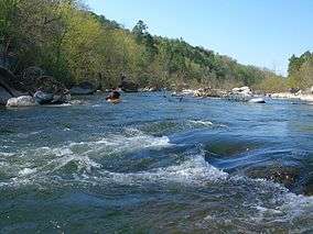
A kayaker on the St. Francis River at Silver Mines Recreation Area in the Mark Twain National Forest | |
 | |
| Location | Missouri, United States |
| Nearest city | Rolla, MO |
| Coordinates | 37°38′13″N 91°05′24″W / 37.637°N 91.09°WCoordinates: 37°38′13″N 91°05′24″W / 37.637°N 91.09°W |
| Area | 1,491,840 acres (6,037.3 km2)[1] |
| Established | September 11, 1939[2] |
| Governing body | U.S. Forest Service |
| Website | Mark Twain National Forest |

Mark Twain National Forest (MTNF) is a U.S. National Forest located in the southern half of Missouri. MTNF was established on September 11, 1939. It is named for author Mark Twain, a Missouri native. The MTNF covers 1,491,840 acres (6,037.3 km2), 78,000 acres (320 km2) of which are Wilderness, and National Scenic River area. MTNF spans 29 counties and represents 11% of all forested land in Missouri. MTNF is divided into six distinct ranger districts: Ava-Cassville-Willow Springs, Eleven Point, Houston-Rolla, Cedar Creek, Poplar Bluff, Potosi-Fredericktown, and the Salem. The six ranger districts actually comprise nine overall unique tracts of forests. Its headquarters are in Rolla, Missouri.
Some unique features of the Mark Twain include Greer Spring, which is the largest spring on National Forest land and part of the Eleven Point National Scenic River, and pumps an average of 214 million gallons of water per day into the river.[3] The public can also visit the Glade Top Trail National Scenic Byway, which offers views of over 30 miles (48 km) to the Boston Mountains in Arkansas. The 350-mile Ozark Trail system winds through much of the National Forest.
History
The Mark Twain National Forest, as we know it today, was created on February 17, 1976. The Mark Twain National forest has a rather unusual history – for it was once known as both the Clark National Forest and the Mark Twain National Forest – both being proclaimed on September 11, 1939.
In June 1973 the Clark and Mark Twain NF were brought under one headquarters in Rolla and became known as the National forests in Missouri. On Feb. 17, 1976, the forests were combined and renamed the Mark Twain National Forest.
Missouri’s only national forest, The Mark Twain, encompasses roughly 1.5 million acres, mostly within the Ozark Highlands. Located across southern Missouri and northern Arkansas, the Ozark Highlands are an ancient landscape characterized by large permanent springs, over 5,000 caves, rocky barren glades, old volcanic mountains and nationally recognized streams. Portions of the Ozarks were never under oceans, nor were the areas glaciated.
In the 1870s, citizens of southern Missouri began an era of extensive logging of the state's native oak, hickory, and pine forests. Lumber mills were commonplace, but by the 1920s they had disappeared, along with much of the state's native forests. Thus, in 1939 President Franklin D. Roosevelt signed the MTNF into existence. In March 1933, he also created the Emergency Conservation Work Act, better known as the Civilian Conservation Corps (CCC). In the area that would later become Mark Twain National Forest, hundreds of young men at over fifty CCC sites worked at building roads and planting hundreds of acres of pine to preserve and enhance the natural resources of southern Missouri. Many of their contributions can still be visited and enjoyed today.
Wilderness areas
Counties
Although it is far from being the largest National Forest in acreage, Mark Twain National Forest is located in more counties than any other. As of September 30, 2007, its 1,490,862 acres (2,329.47 sq mi, or 6,033.3 km²) were spread over parts of 29 counties in southern and central Missouri.[4]
| County | Area | |
|---|---|---|
| Acres | Hectares | |
| Oregon County | 104,721 | 42,379 |
| Ripley County | 97,437 | 39,431 |
| Iron County | 96,047 | 38,869 |
| Carter County | 90,641 | 36,681 |
| Reynolds County | 89,933 | 36,395 |
| Wayne County | 88,372 | 35,763 |
| Shannon County | 83,934 | 33,967 |
| Washington County | 82,133 | 33,238 |
| Dent County | 73,011 | 29,547 |
| Taney County | 65,953 | 26,690 |
| Phelps County | 65,379 | 26,458 |
| Barry County | 55,187 | 22,333 |
| Christian County | 52,260 | 21,149 |
| Madison County | 51,170 | 20,708 |
| Howell County | 50,504 | 20,438 |
| Crawford County | 50,048 | 20,254 |
| Texas County | 49,581 | 20,065 |
| Butler County | 48,494 | 19,625 |
| Douglas County | 41,030 | 16,604 |
| Pulaski County | 39,177 | 15,854 |
| Ozark County | 38,672 | 15,650 |
| Laclede County | 30,542 | 12,360 |
| Callaway County | 12,467 | 5,045 |
| Stone County | 10,335 | 4,182 |
| Sainte Genevieve County | 10,254 | 4,150 |
| Wright County | 7,159 | 2,897 |
| Boone County | 4,102 | 1,660 |
| Bollinger County | 1,646 | 666 |
| Saint Francois County | 673 | 272 |
Climate
| Climate data for Mark Twain National Forest | |||||||||||||
|---|---|---|---|---|---|---|---|---|---|---|---|---|---|
| Month | Jan | Feb | Mar | Apr | May | Jun | Jul | Aug | Sep | Oct | Nov | Dec | Year |
| Record high °F (°C) | 75 (24) |
80 (27) |
88 (31) |
90 (32) |
94 (34) |
100 (38) |
107 (42) |
104 (40) |
99 (37) |
94 (34) |
83 (28) |
75 (24) |
107 (42) |
| Average high °F (°C) | 43 (6) |
48 (9) |
58 (14) |
68 (20) |
75 (24) |
83 (28) |
88 (31) |
87 (31) |
80 (27) |
69 (21) |
57 (14) |
44 (7) |
67 (19) |
| Average low °F (°C) | 21 (−6) |
25 (−4) |
33 (1) |
42 (6) |
52 (11) |
61 (16) |
65 (18) |
64 (18) |
55 (13) |
44 (7) |
34 (1) |
25 (−4) |
43 (6) |
| Record low °F (°C) | −19 (−28) |
−11 (−24) |
−2 (−19) |
18 (−8) |
28 (−2) |
40 (4) |
44 (7) |
39 (4) |
30 (−1) |
19 (−7) |
4 (−16) |
−10 (−23) |
−19 (−28) |
| Average precipitation inches (mm) | 2.1 (53) |
2.29 (58.2) |
4.18 (106.2) |
4.28 (108.7) |
4.95 (125.7) |
4.22 (107.2) |
3.70 (94) |
3.40 (86.4) |
3.91 (99.3) |
3.44 (87.4) |
3.91 (99.3) |
3.30 (83.8) |
43.68 (1,109.2) |
| Average snowfall inches (cm) | 6.7 (17) |
4.6 (11.7) |
2.1 (5.3) |
0.3 (0.8) |
0 (0) |
0 (0) |
0 (0) |
0 (0) |
0 (0) |
0.3 (0.8) |
0.9 (2.3) |
7.1 (18) |
22 (55.9) |
| Source: [5] | |||||||||||||
References
- ↑ "Land Areas of the National Forest System" (PDF). U.S. Forest Service. January 2012. Retrieved June 24, 2012.
- ↑ "The National Forests of the United States" (PDF). ForestHistory.org. Retrieved July 20, 2012.
- ↑ http://www.dnr.mo.gov/env/wrc/springsandcaves.htm
- ↑ Table 6 - NFS Acreage by State, Congressional District and County - United States Forest Service - September 30, 2007
- ↑ http://wwworigin.weather.com/weather/wxclimatology/monthly/graph/0905:13
External links
| Wikimedia Commons has media related to Mark Twain National Forest. |
| Wikivoyage has a travel guide for Mark Twain National Forest. |
- "Mark Twain National Forest". USDA Forest Service. Retrieved February 6, 2006.