Jinja–Iganga–Bugiri–Tororo Road
| Jinja–Iganga–Bugiri–Tororo Road | |
|---|---|
| Route information | |
| Length: | 81 mi (130 km) |
| Major junctions | |
| West end: | Jinja |
|
Iganga Bugiri Busitema | |
| East end: | Tororo |
| Highway system | |
| Roads in Uganda | |
The Jinja–Iganga–Bugiri–Tororo Road is a road in the Eastern Region of Uganda, connecting the towns of Jinja and Tororo. Sometimes referred to as Tororo–Jinja Road, it is a busy transport corridor, connecting traffic from neighboring Kenya, and northeastern Uganda to Jinja, a major commercial and industrial center, and ultimately to Kampala, the country's capital and points beyond.
Location
The road starts at Jinja, in Jinja District, proceeding eastwards, through Bugembe and Kakira, Iganga, Bugiri and Busitema, to end at Tororo Corner, where it merges with Tororo–Mbale–Soroti Road and with Tororo–Malaba Road, a total distance of about 130 kilometres (81 mi).[1] The coordinates of the road at Bugiri are:0°34'21.0"N, 33°44'46.0"E (Latitude:0.572507; Longitude:33.746120).[2]
Overview
The road is an all-weather tarmac, single carriageway road in good condition. This road is part of the Northern Corridor, a road system that connects the East African cities of Bujumbura, in Burundi, Kigali, in Rwanda and Kampala, in Uganda to Nairobi, in Kenya and ultimately to the Kenyan port of Mombasa. The road is a vital commercial link to the outside world for the three land-locked countries. It is also a vital road link to the sea, for many parts of eastern Democratic Republic of the Congo.[3]
Points of interest
The following points of interest lie along or near the Jinja–Iganga–Bugiri–Tororo Road:
- The town of Bugembe, the headquarters of Busoga.[4]
- The town of Kakira, the headquarters of the Madhvani Group.[5]
- This road confluences with the Musita–Mayuge–Lumino–Majanji–Busia Road at Musita.[6]
- Busoga University, in the town of Iganga.[7]
- Iganga General Hospital in the town of Iganga
- This road intersects with the Iganga–Tirinyi–Kamonkoli–Mbale Road, at Nakalama, about 7.5 kilometres (5 mi) east of Iganga.[8]
- Bugiri General Hospital in the town of Bugiri.[9]
- Headquarters and factory of Tilda Ugada Limited, the largest commercial rice project in Uganda, located at Kibimba, about 18 kilometres (11 mi) east of Bugiri.[10][11]
- The main campus of Busitema University at Busitema.
- The headquarters and factory of Tororo Cement Limited at Tororo.
See also
References
- ↑ GFC (11 June 2016). "Distance between Jinja Train Station, Jinja, Eastern Region, Uganda and Corner, Tororo, Eastern Region, Uganda". Globefeed.com (GFC). Retrieved 11 June 2016.
- ↑ Google (11 June 2016). "Location of Jinja–Iganga–Bugiri–Tororo Road" (Map). Google Maps. Google. Retrieved 11 June 2016.
- ↑ NCTTCA (11 June 2016). "Northern Corridor Transit Transport Coordinating Authority: Background". Mombasa: Northern Corridor Transit Transport Coordinating Authority (NCTTCA). Retrieved 11 June 2016.
- ↑ BTL (11 June 2016). "Busoga Trust: Where We Work: Bugembe". London: Busoga Trust Limited (BTL). Retrieved 11 June 2016.
- ↑ KSW (11 June 2016). "Kakira Sugar: About Us". Kakira Sugar Works (KSW). Retrieved 11 June 2016.
- ↑ Google (11 June 2016). "Location of the Confluemve Between the Jinja–Iganga–Bugiri–Tororo Road And Musita–Mayuge–Lumino–Majanji–Busia Road" (Map). Google Maps. Google. Retrieved 11 June 2016.
- ↑ Google (11 June 2016). "Location of Busoga University Main Campus" (Map). Google Maps. Google. Retrieved 11 June 2016.
- ↑ GFC (11 June 2016). "Distance between Iganga, Eastern Region, Uganda and Nakalama, Eastern Region, Uganda". Globefeed.com (GFC). Retrieved 11 June 2016.
- ↑ "Location of Bugiri General Hospital". Retrieved 11 June 2016.
- ↑ IFC (22 October 1997). "Revised Environmental Review Summary (ERS): Project Name - Uganda: Tilda Uganda Limited: Project Number: 008136". Washington DC: International Finance Corporation (IFC). Retrieved 11 June 2016.
- ↑ GFC (11 June 2016). "Distance between Bugiri, Eastern Region, Uganda and Tilda Uganda Limited, Kibimba, Bugiri, Eastern Region, Uganda". Globefeed.com (GFC). Retrieved 11 June 2016.
External links
Capital: Buwenge | ||
| Counties and sub-counties | Butembe County | 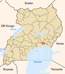 |
| Towns and villages | ||
| Economy |
| |
| Energy | ||
| Notable landmarks | ||
| Education |
| |
| Transport | ||
| Health | ||
| Notable people |
| |
Capital: Mayuge | ||
| Towns and villages | ||
| Geography | ||
| Economy | ||
| Energy | ||
| Transport | ||
| Health | ||
| Notable people | ||
Capital: Iganga | ||
| Towns and villages |
| |
| Transport |
| |
| Banking | ||
| Health | ||
| Education | ||
| Notable people | ||
Capital: Bugiri | ||
| Towns and villages | ||
| Geography | ||
| Economy | ||
| Banking | ||
| Transport | ||
| Health | ||
| Notable people | ||
Capital: Busia | ||
| Towns and villages | ||
| Geography | ||
| Banking | ||
| Transport | ||
| Health | ||
| Education | ||
| Notable people | ||
Capital: Tororo | ||
| Towns and villages | ||
| Geography |
| |
| Economy | ||
| Banking | ||
| Energy | ||
| Health |
| |
| Transport |
| |
| Notable landmarks | ||
| Education | ||
| Notable people | ||
Coordinates: 00°34′21″N 33°34′46″E / 0.57250°N 33.57944°E