Jinja District
| Jinja District | |
|---|---|
| District | |
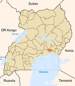 District location in Uganda | |
| Coordinates: 00°30′N 33°12′E / 0.500°N 33.200°ECoordinates: 00°30′N 33°12′E / 0.500°N 33.200°E | |
| Country |
|
| Region | Eastern Region |
| Sub-region | Busoga sub-region |
| Capital | Buwenge |
| Area | |
| • Land | 673 km2 (260 sq mi) |
| Elevation | 1,200 m (3,900 ft) |
| Population (2012 Estimate) | |
| • Total | 501,300 |
| • Density | 744.9/km2 (1,929/sq mi) |
| Time zone | EAT (UTC+3) |
| Website |
www |
Jinja District is a district in the Eastern Region of Uganda. The town of Jinja is the district's main municipal and commercial center.
Location
Jinja District is bordered by Kamuli District to the north, Luuka District to the east, Mayuge District to the south-east, Buvuma District to the south, Buikwe District to the west, and Kayunga District to the north-west. The district headquarters at Buwenge[1] are located 96 kilometres (60 mi), by road, east of Kampala, Uganda's capital and largest city.[2]
Population
In 1991, the national population census estimated the district population at 289,500. The 2002 national census estimated the population at 387,600, with an annual population growth rate of 2.7 percent. In 2012, the population was estimated at 501,300.[3]
See also
References
- ↑ Nankya, Sylvia (12 February 2014). "IGG Clears Jinja Land Allocation to Bank of Uganda". Uganda Radio Network. Retrieved 18 May 2014.
- ↑ "Road Distance Between Kampala And Buwenge With Map". Globefeed.com. Retrieved 18 May 2014.
- ↑ "Estimated Population of Jinja District In 1991, 2002 & 2012". Citypopulation.de. Retrieved 18 May 2014.
External links
Capital: Buwenge | ||
| Counties and sub-counties | Butembe County | |
| Towns and villages | ||
| Economy |
| |
| Energy | ||
| Notable landmarks | ||
| Education |
| |
| Transport | ||
| Health | ||
| Notable people |
| |