Bugembe
| Bugembe | |
|---|---|
 Bugembe Map of Uganda showing the location of Bugembe. | |
| Coordinates: 00°28′03″N 33°14′29″E / 0.46750°N 33.24139°E | |
| District | Jinja District |
| Elevation | 1,269 m (4,163 ft) |
| Population (2011 Estimate) | |
| • Total | 33,100 |
| Time zone | EAT (UTC+3) |
Bugembe is a town in Jinja District in the Eastern Region of Uganda. It is the seat of the Kingdom of Busoga, one of the four constitutional mornachies in Uganda, which is coterminus with the Busoga sub-region.
Location
Bugembe is located approximately 8 kilometres (5.0 mi), by road, northeast of Jinja, the largest city in the sub-region.[1] The town is located on the highway between Jinja and Iganga. The coordinates of Bugembe are:0°28'03.0"N, 33°14'29.0"E (Latitude:0.467500; Longitude:33.241389).[2] The town sits at an average elevation of 1,269 metres (4,163 ft) above sea level.[3]
Population
In 2002, the national census counted the town's population as 26,268. In 2010, the Uganda Bureau of Statistics (UBOS) estimated the population at 32,200. In 2011, UBOS estimated the mid-year population at 33,100.[4]
Points of interest
The following points of interest lie within the town limits or near the edges of town:
- offices of Bugembe Town Council
- headquarters of the Kingdom of Busoga
- Bugembe Police Barracks
- Nakanyangi Primary School
- Jinja Lake View Primary School
- Nakanyonyi Girls' Primary School
- St. Thaddeus Secondary School
- Bugembe central market
- Bugembe Health Center
- St. Florence Secondary School
- Vic View High School
- Wanyange Girls' Secondary School
See also
References
- ↑ "Road Distance Between Jinja and Bugembe With Map". Globefeed.com. Retrieved 3 July 2015.
- ↑ Google (3 July 2015). "Location of Bugembe At Google Maps" (Map). Google Maps. Google. Retrieved 3 July 2015.
- ↑ FMN, . (3 July 2015). "Elevation of Bugembe, Uganda Elevation Map, Topo, Contour". Floodmap.net (FMN). Retrieved 3 July 2015.
- ↑ "Estimated Population of Bugembe In 2002, 2010 & 2011" (PDF). Uganda Bureau of Statistics. Archived from the original (PDF) on 7 July 2014. Retrieved 3 July 2015.
Capital: Buwenge | ||
| Counties and sub-counties | Butembe County | 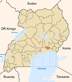 |
| Towns and villages | ||
| Economy |
| |
| Energy | ||
| Notable landmarks | ||
| Education |
| |
| Transport | ||
| Health | ||
| Notable people |
| |
Coordinates: 00°28′03″N 33°14′29″E / 0.46750°N 33.24139°E