Jasper, Oregon
| Jasper | |
|---|---|
| Unincorporated community | |
|
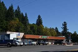
Store in Jasper | |
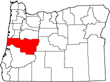
 Jasper  Jasper Location within the state of Oregon | |
| Coordinates: 43°59′48″N 122°54′18″W / 43.99667°N 122.90500°WCoordinates: 43°59′48″N 122°54′18″W / 43.99667°N 122.90500°W | |
| Country | United States |
| State | Oregon |
| County | Lane |
| Time zone | Pacific (PST) (UTC-8) |
| • Summer (DST) | PDT (UTC-7) |
| ZIP code | 97438 |
| Area code(s) | 458 and 541 |
Jasper is an unincorporated community in Lane County, Oregon, United States. It is southeast of Springfield on Oregon Route 222, at the confluence of Hills Creek and the Middle Fork Willamette River.
Jasper was the site of a siding of the Southern Pacific Railroad's Cascade Line (now part of the Union Pacific Railroad), which was named for local resident Jasper B. Hills, the son of Cornelius Joel Hills, who settled at the locale in 1846.[1] The Jasper post office was established in 1884.[1]
Jasper State Recreation Site, a state park, is south of Jasper.
Jasper is served by the Pleasant Hill School District.
References
- 1 2 McArthur, Lewis A.; McArthur, Lewis L. (2003) [1928]. Oregon Geographic Names (7th ed.). Portland, Oregon: Oregon Historical Society Press. p. 508. ISBN 978-0875952772.
External links
- Images of covered bridges in the Jasper area from Salem Public Library
This article is issued from Wikipedia - version of the 7/30/2016. The text is available under the Creative Commons Attribution/Share Alike but additional terms may apply for the media files.