Walden, Oregon
| Walden | |
|---|---|
| Unincorporated community | |
 | |
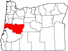
 Walden  Walden Location within the state of Oregon | |
| Coordinates: 43°46′31″N 123°0′19″W / 43.77528°N 123.00528°WCoordinates: 43°46′31″N 123°0′19″W / 43.77528°N 123.00528°W | |
| Country | United States |
| State | Oregon |
| County | Lane |
| Time zone | Pacific (PST) (UTC-8) |
| • Summer (DST) | PDT (UTC-7) |
| ZIP codes | 97424 |
Walden is an unincorporated community in Lane County, Oregon, United States.[1] It is about 3 miles (5 km) southeast of Cottage Grove, near the confluence of the Row River and Mosby Creek.[2]
Walden was a station on the Oregon and Southeastern Railroad (now converted to the Row River Trail).[3] According to state representative and local lumber company owner L. L. "Stub" Stewart, the station was named for a family of early residents in the area.[3] There is a Nathan B. Walden listed in the 1880 Census for the Cottage Grove Precint.[3] The 1973 film Emperor of the North was shot in the Walden area along the rail line.[4]
The Brumbaugh covered bridge, a National Register of Historic Places property, once stood near Walden, spanning Mosby Creek.[5][6] It was dismantled and the wood used in the Centennial Covered Bridge in Cottage Grove.[7] The Stewart and Mosby Creek bridges still stand in the Walden area, as well as the historic Walden Store & Gas Station building, built circa 1900.[4] The store closed in about 2002.[8]
Notable people
Opal Whiteley and her grandparents lived in Walden and Opal mentioned the area in her book The Diary of Opal Whiteley.[9]
References
- ↑ "Walden". Geographic Names Information System. United States Geological Survey. May 22, 1986. Retrieved November 15, 2015.
- ↑ Oregon Atlas & Gazetteer (7th ed.). Yarmouth, Maine: DeLorme. 2008. p. 47. ISBN 0-89933-347-8.
- 1 2 3 McArthur, Lewis A.; McArthur, Lewis L. (2003) [1928]. Oregon Geographic Names (7th ed.). Portland, Oregon: Oregon Historical Society Press. p. 1000. ISBN 978-0875952772.
- 1 2 "Walden Store & Gas Station" (PDF). Oregon Historic Sites Database. Oregon Parks and Recreation Department. Retrieved November 15, 2015.
- ↑ "Brumbaugh Bridge". Oregon Historic Sites Database. Oregon Parks and Recreation Department. Retrieved November 15, 2015.
- ↑ "Brumbaugh Covered Bridge" (PDF). Oregon State Historic Preservation Office. Retrieved November 15, 2015.
- ↑ "Centennial Covered Bridge". Lane County, Oregon. Retrieved November 15, 2015.
- ↑ "Minutes of the Lane County Planning Commission" (PDF). Lane County, Oregon. February 7, 2012. p. 4. Retrieved November 15, 2015.
- ↑ Williamson, Stephen. "Visit Opal's Fairyland". Discover the Magic & Mystery of Opal. Retrieved November 15, 2015.
External links
- Historic images of Walden from Salem Public Library
- Image of the Walden School from Center for Electronic Studying, University of Oregon
- Images of Walden from Flickr