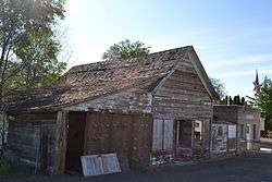
Jamieson, Oregon
| Jamieson, Oregon | |
|---|---|
| Unincorporated community | |
 | |
 Jamieson, Oregon  Jamieson, Oregon | |
| Coordinates: 44°10′56″N 117°26′17″W / 44.18222°N 117.43806°WCoordinates: 44°10′56″N 117°26′17″W / 44.18222°N 117.43806°W | |
| Country | United States |
| State | Oregon |
| County | Malheur |
| Elevation | 2,500 ft (800 m) |
| Time zone | Pacific (PST) (UTC-8) |
| • Summer (DST) | PDT (UTC-7) |
| ZIP code | 97909 |
| Area code(s) | 541 |
| GNIS feature ID | 1136418[1] |
Jamieson is an unincorporated community in Malheur County, Oregon, United States. Jamieson is located on U.S. Route 26 17 miles (27 km) northwest of Vale. Jamieson has a post office with ZIP code 97909.[2]
References
- ↑ "US Board on Geographic Names". United States Geological Survey. 2007-10-25. Retrieved 2008-01-31.
- ↑ "Find Locations". U.S. Postal Service. Retrieved October 31, 2013.
Municipalities and communities of Malheur County, Oregon, United States | ||
|---|---|---|
| Cities | 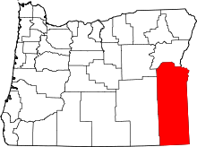 | |
| CDPs | ||
| Other unincorporated communities | ||
| Ghost town | ||
This article is issued from Wikipedia - version of the 7/31/2016. The text is available under the Creative Commons Attribution/Share Alike but additional terms may apply for the media files.