Burns Junction, Oregon
| Burns Junction | |
|---|---|
| Unincorporated community | |
|
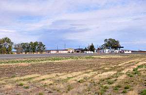
Burns Junction skyline | |
 Burns Junction  Burns Junction Location within the state of Oregon | |
| Coordinates: 42°46′37″N 117°51′12″W / 42.77694°N 117.85333°WCoordinates: 42°46′37″N 117°51′12″W / 42.77694°N 117.85333°W | |
| Country | United States |
| State | Oregon |
| County | Malheur |
| Elevation | 3,934 ft (1,199 m) |
| Time zone | MST (UTC-7) |
| • Summer (DST) | MDT (UTC-6) |
| ZIP codes | 97910 |
| Area code(s) | 541 |
| Coordinates and elevation from United States Geological Survey[1] | |
Burns Junction is an unincorporated community in Malheur County, Oregon, United States,[1] located at the intersection of U.S. Route 95 and Oregon Route 78, about 80 miles (130 km) southeast of the Harney County city of Burns.
Climate
According to the Köppen Climate Classification system, Burns Junction has a semi-arid climate, abbreviated "BSk" on climate maps.[2]
References
- 1 2 "Burns Junction". Geographic Names Information System. United States Geological Survey. November 28, 1980. Retrieved November 13, 2010.
- ↑ Climate Summary for Burns Junction, Oregon
Municipalities and communities of Malheur County, Oregon, United States | ||
|---|---|---|
| Cities | 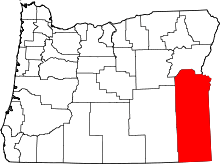 | |
| CDPs | ||
| Other unincorporated communities | ||
| Ghost town | ||
This article is issued from Wikipedia - version of the 7/30/2016. The text is available under the Creative Commons Attribution/Share Alike but additional terms may apply for the media files.