Ivybridge
| Ivybridge | |
 Ivybridge |
|
| Population | 11,851 (2011)[1] |
|---|---|
| OS grid reference | SX635560 |
| – London | 182 miles (293 km) |
| Civil parish | Ivybridge |
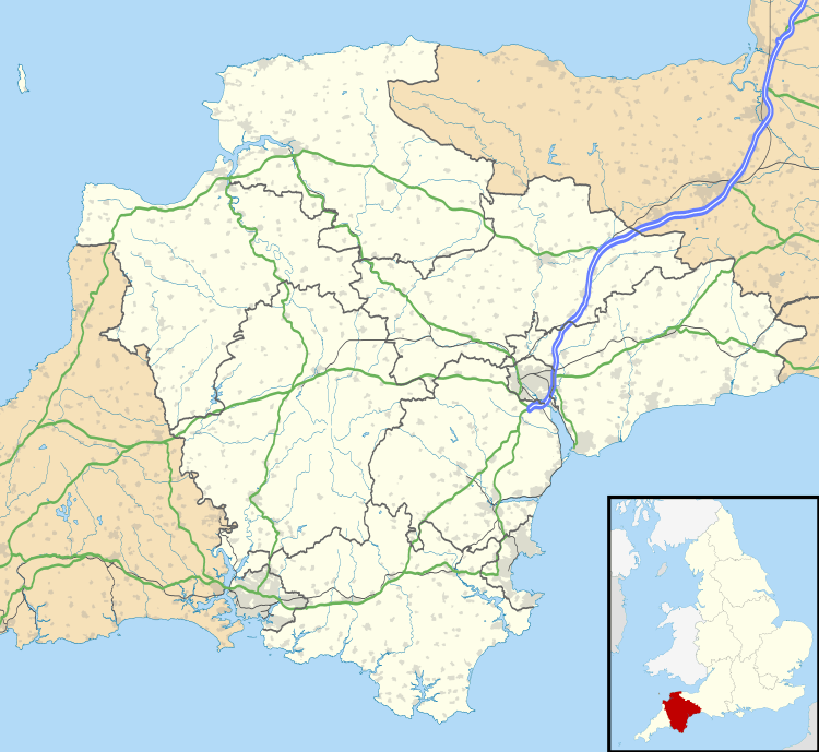
| District | South Hams |
| Shire county | Devon |
| Region | South West |
| Country | England |
| Sovereign state | United Kingdom |
| Post town | IVYBRIDGE |
| Postcode district | PL21 |
| Dialling code | 01752 |
| Police | Devon and Cornwall |
| Fire | Devon and Somerset |
| Ambulance | South Western |
| EU Parliament | South West England |
| UK Parliament | South West Devon |
| Website | www.ivybridge.gov.uk |
Coordinates: 50°23′20″N 3°55′16″W / 50.389°N 3.921°W
Ivybridge ![]() i/ˈaɪvibrɪdʒ/ is a small town and civil parish in the South Hams, in Devon, England. It lies about 9 miles (14.5 km) east of Plymouth. It is at the southern extremity of Dartmoor, a National Park of England and Wales and lies along the A38 "Devon Expressway" road. There are three electoral wards in Ivybridge (Central, Filham & Woodlands) with a total population of 11,851.
i/ˈaɪvibrɪdʒ/ is a small town and civil parish in the South Hams, in Devon, England. It lies about 9 miles (14.5 km) east of Plymouth. It is at the southern extremity of Dartmoor, a National Park of England and Wales and lies along the A38 "Devon Expressway" road. There are three electoral wards in Ivybridge (Central, Filham & Woodlands) with a total population of 11,851.
Mentioned in documents as early as the 13th century, Ivybridge's early history is marked by its status as an important crossing-point over the River Erme on the Exeter-to-Plymouth route. In the 16th century mills were built using the River Erme's power. The parish of Saint John was formed in 1836.[2] Ivybridge became a civil parish in 1894 and a town in 1977.
The early urbanisation and development of Ivybridge largely coincided with the Industrial Revolution. When the South Devon Railway Company built its train route through Ivybridge in the 19th century a paper mill was constructed alongside it and this led to an increase in housing nearby. The paper mill recently closed, after over 150 years in the town, and the buildings are being converted to homes and shops. Although occasionally referred to as a dormitory town, many people work in the town itself, and agriculture continues to play an economic role for Ivybridge's hinterland. The area surrounding Ivybridge is almost completely farmland.
While heavy industry diminished during the latter half of the 20th century, the population grew significantly from 1,574 people in 1921 to 12,056 in 2001.[3]
History

The name Ivybridge is derived from a small 13th-century hump-backed bridge of the same name. Apart from swimming, it was the only means of crossing the river until 1819. "Ivy" was used to describe the bridge, because there was ivy growing on the bridge. As the bridge was the centre of the village and important to its very existence, it was named the "parish of Ivybridge" in 1894.[3]
The first mention of settlement in Ivybridge was the manor of Stowford in the Domesday Book of 1086.[4] Although the first mention of Ivybridge came in 1280 when it was described as "dowry of land on the west side of the River Erme, by the Ivy Bridge."[5] There was a chapel, that was on the site of Saint John's church, since 1402.[6] From the 16th century onwards mills were built in the town, harnessing the power of the river. Records show that in the 16th century there was a corn mill, a tin mill and an edge mill. One of the mills, 'Glanville's Mill' (a corn mill), was situated where many of the town's shops are today and gives its name to the shopping centre.[5] The first church (Saint John's) was built in 1790 as a chapel of ease, but 45 years later in 1835 it was consecrated as a district church.[2] In 1819 the Ivy Bridge lost its position as the only means of crossing the river when the 'New Bridge' was built joining Fore Street and Exeter Road.
In 1977 Ivybridge became a town. Throughout the 1980s and 90s it underwent a period of rapid growth, perhaps due to the A38 road by-pass. Between the censuses in 1981 and 2001 the population more than doubled from 5,106 to 12,056.[3]
Governance


Ivybridge is represented by five tiers of elected government.
- Ivybridge Town Council forms the lowest tier of local government.[7] Ivybridge town council consists of sixteen council members who are elected from two wards, Ivybridge East and Ivybridge West. The council members are elected every four years and a town mayor is elected every year by the town council members. The town council is responsible for the provision of a number of local services including the management of parks, open spaces, cemeteries, and allotments.[8] A committee of the town council reviews all planning applications and makes recommendations to the District Council, which is the planning authority for the town. The town council also represents the views of the town on issues such as local transport, policing and the environment. The town council raises its own tax to pay for these services, known as the parish precept, which is collected as part of the Council Tax.
- The next tier is the district council — South Hams District Council. They take care of matters such as local planning and building control, local roads, council housing, environmental health, markets and fairs, refuse collection and recycling, cemeteries and crematoria, leisure services, parks, and tourism.
- The next tier is Devon County Council, who take care of much larger matter such as: education, social services, libraries, main roads, public transport, policing and fire service trading standards, waste disposal and strategic planning.
- The Parliament of the United Kingdom is responsible for matters such as education, health and justice.
- The highest elected authority is the European Parliament in Brussels.
It is a town and parish divided into two wards: Ivybridge East (the east of the River Erme) and Ivybridge West (the west of the River Erme).[9] The current mayor is Councillor Dave Gray-Taylor who was appointed in 2015.[7] In 2007 Ivybridge town council won the Aon/NALC (National Association of Local Councils) Council of the Year.[10] There is a town hall which is located close to the centre of the town and the previous town hall – Chapel Place is still in existence and located in the centre of the town close to the Ivy Bridge.
Before 1894 Ivybridge was made up of four neighbouring parishes: Harford – 2 miles (3.2 km) north; Ugborough – 2.5 miles (4.0 km) east; Ermington – 2 miles (3.2 km) south and Cornwood – 3 miles (4.8 km) northwest.[11] All the parishes' boundaries met at the Ivy Bridge. In 1836 the Parish of Saint John was formed (the name of the church at the time, which was named after John the Evangelist). The parish represented the small central area of Ivybridge known at present. In 1894 St John's parish became a parish church for the newly created parish of Ivybridge.[3] 83 years later the village and civil parish of Ivybridge became a town in 1977. Its local government district has been the South Hams since 1 April 1974 and its county constituency has been South West Devon since 1997.
The town forms part of the county constituency of South West Devon. Its Member of Parliament is Gary Streeter formerly an SDP politician, but now a member of the Conservative party who held 56.6% of the votes at the 2015 election.[12] The town's two wards are each used for voting at the local elections and general elections.[13]
International links
Ivybridge's first official twinning was with Saint-Pierre-sur-Dives in 1972 before Ivybridge became a town. Since then it has developed unofficial town twinnings (exchanges) and friendship treaties:[14]
-
 France: Saint-Pierre-sur-Dives, Lower Normandy, since 1972
 -
 Germany: Beverungen, North Rhine-Westphalia, since 1975 (then in West Germany)
 -
 United States: Bedford, Virginia, since 2004
Geography
| Ivybridge[15] | ||||||||||||||||||||||||||||||||||||||||||||||||||||||||||||
|---|---|---|---|---|---|---|---|---|---|---|---|---|---|---|---|---|---|---|---|---|---|---|---|---|---|---|---|---|---|---|---|---|---|---|---|---|---|---|---|---|---|---|---|---|---|---|---|---|---|---|---|---|---|---|---|---|---|---|---|---|
| Climate chart (explanation) | ||||||||||||||||||||||||||||||||||||||||||||||||||||||||||||
| ||||||||||||||||||||||||||||||||||||||||||||||||||||||||||||
| ||||||||||||||||||||||||||||||||||||||||||||||||||||||||||||
At coordinates 50°23′28″N 3°55′12″W / 50.39111°N 3.92000°W Ivybridge is situated deep in the south western peninsula of England, Ivybridge is 182 miles (293 km) from London, 10 miles (16 km) from Totnes and 28 miles (45 km) from Exeter. The main road in and out of the town (the A38) allows fast access to its nearby city Plymouth for many of Ivybridge's commuters.
The topography of Ivybridge is generally hilly. This is because of the River Erme which flows right through the centre of town. To the east and to the west of the river the land is elevated forming a valley. The river first enters the town at 90 metres (300 ft) metres above sea level and leaves the town at 40 metres (130 ft) metres above sea level. At its height the top of the east and west of the valley is 80 metres (260 ft) metres above sea level. The western beacon is a hill that overlooks the town; its peak can be seen from almost anywhere in the town. It's 328 metres (1,076 ft) metres above sea level and 278 metres (912 ft) metres above the town. There is also an area of woodland called Longtimber woods to the north of the town, which attracts many walkers along its riverside path.
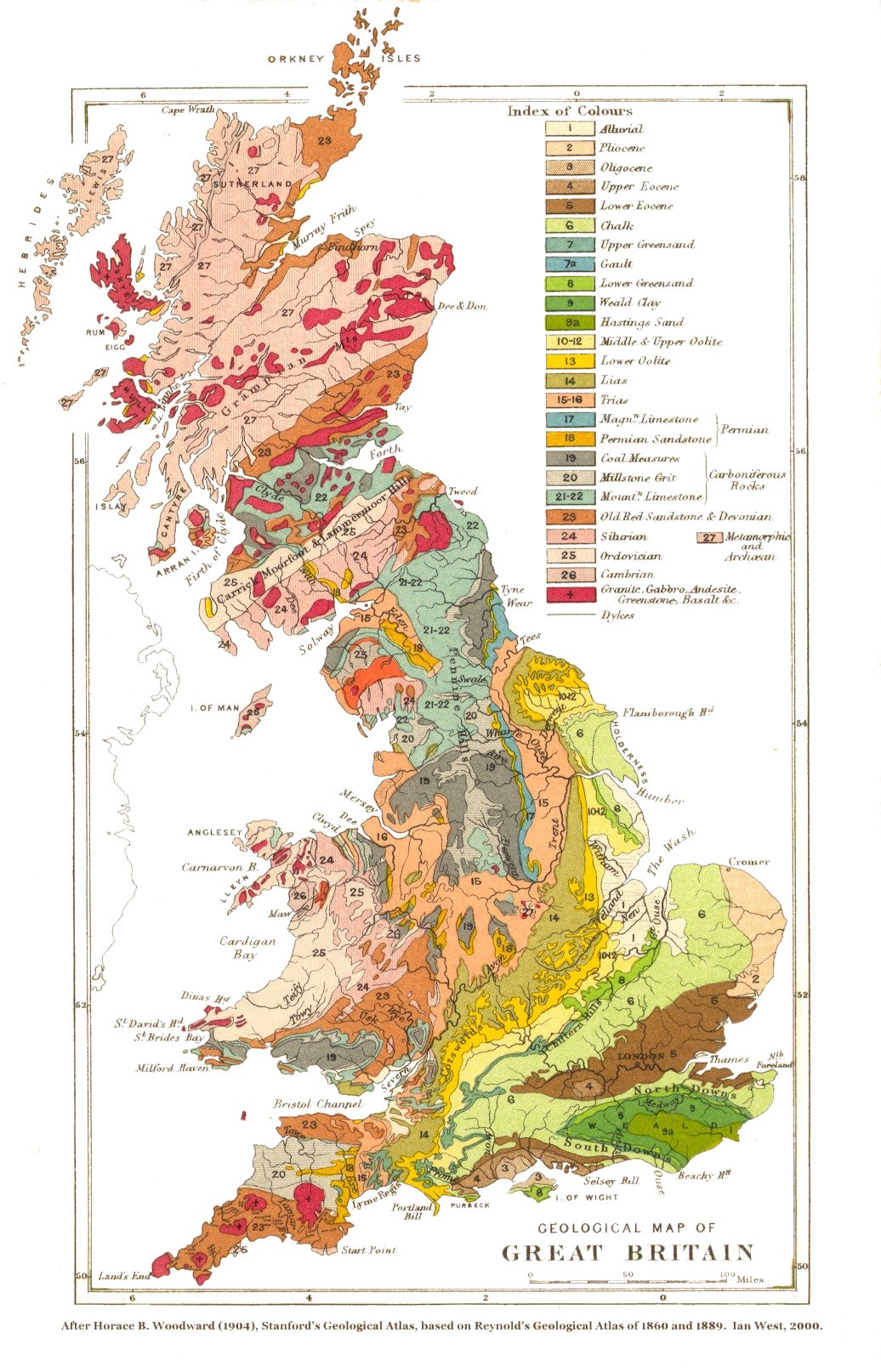
The geology of Ivybridge is varied. Throughout most of the town the rock is Old Red Sandstone (sedimentary) from the Devonian period.[16] To the north of the town Granite can be found as it is situated on the slopes of Dartmoor – a large pre-volcanic area of Granite. Along the River Erme large boulders and rocks can be found deposited on its meandering path brought all the way from Dartmoor; the Ivy Bridge itself is made out of Granite.

The built environment in and around Ivybridge is mainly characterised by its suburban streets plans and houses, although in the centre of Ivybridge it's mainly characterised by Victorian buildings. From the centre of the town most buildings are terraced and now many of these buildings have been converted into retail outlets along Fore Street – the town's central business district. In the middle layer of the town most buildings are semi-detached and built on quite steep roads. More detached houses are found on the outer layers of the city on the east and on the west of the town. Over the past decades the town has been shaped by its two most essential pieces of infrastructure: the railway line to the north and the A38 dual carriageway to the south. No large scaling housing has been built on either side of these boundaries. Due to this Ivybridge has been forced to grow east and west rather than north and south; it stretches approximately 1.76 miles (2.83 km) from east to west and 1 mile (1.6 km) from north to south.
Climate
Along with the rest of South West England, Ivybridge has a temperate climate which is generally wetter and milder than the rest of the British Isles. The annual mean temperature is approximately 11 °C (52 °F) and shows a seasonal and a diurnal variation, but due to the modifying effect of the sea the range is less than in most other parts of the British Isles.[17] February is the coldest month with mean minimum temperatures between 3 °C (37 °F) and 4 °C (39 °F). July and August are the warmest months with mean daily maxima over 19 °C (66 °F).[15]
The climate of South West England has a favoured location with respect to the Azores high pressure when it extends its influence north-eastwards towards the British Isles, particularly in summer. Coastal areas have average annual sunshine totals over 1,600 hours.[17]
Rainfall tends to be associated with Atlantic depressions or with convection. The Atlantic depressions are more vigorous in autumn and winter and most of the rain which falls in those seasons in the south-west is from this source. Average annual rainfall is around 980 millimetres (39 in). The number of days with snow falling is typically less than ten per winter. November to March have the highest mean wind speeds, with June to August having the lightest winds. The predominant wind direction is from the south-west[17] and, as a result, the air quality in Ivybridge may be reduced by the (proposed) construction of an incinerator southwest of the town (at the New England Quarry) with possible implications for health.[18]
Demography
.png)
Ivybridge's most recent census indicates that Ivybridge had a population of 11,851.[1] The United Kingdom Census 2011 was carried out by the Office for National Statistics in England and Wales, on Sunday, 27 March 2011.[19] To put that figure into comparison with the area surrounding Ivybridge: it accounts for about 14% of the South Hams' total population (83,140)[1] and it accounts for about 1% of Devon's total population (1,133,800).[20] The town has a median age of 42 (up from 36 since 2001),[21] which is above the national average of 39.[22]
The ethnicity of Ivybridge is predominately white with 98.7% of the population identifying themselves as such. This is slightly higher than the local average of the South Hams (98.3%), although much lower than the national average for England (85.5%). Of the remaining ethnic groups, 0.7% are mixed, 0.5% are Asian, 0.1% are Black and 0.1% are classed as other.[23]
Economy

Ivybridge's earliest known economy relied on the River Erme with a corn mill, tin mill and an edge mill in existence in the town. Later development of the town relied on both the River Erme and the railway, which was part of the Industrial Revolution of the United Kingdom. The largest employer to the town during the Industrial Revolution was Stowford Paper Mill, which led to population growth in the town. The paper mill closed in 2013. With the expansion of the town in the late 20th century much of the new jobs are in the service sector of industry. Due to the A38 Ivybridge's transport to nearby city Plymouth was made possible as a commuter route. As a result, a lot of Ivybridge's work or "economy" is made in Plymouth and nearby towns. Ivybridge does still have some of its own industry with a small industrial estate at the south of the town and very nearby an industrial estate just to the east at Lee Mill. There have been attempts to brand the town as a walking centre for southern Dartmoor. There is good access to Dartmoor from the town. For example, one route follows the route of the old china clay railway to Redlake in the heart of the moor, another glides delightfully by the Erme through Longtimber Woods. There are other accesses to the Moor. The Two Moors Way, which crosses Dartmoor and Exmoor starts in Ivybridge and finishes in Lynmouth on the North Devon coast.
The shopping area is mainly along Fore Street and Glanvilles Mill and provides many jobs and services for the town, although the local schools combine to be biggest employers. There are some out of town jobs at the Tesco Extra superstore at Lee Mill and Endsleigh Garden & Leisure. The town has six traditional public houses: The Sportsmans, The Bridge, The Exchange, The Old Smithy, The Duke of Cornwall and The Imperial.
Landmarks

The town's natural landmark is Western Beacon; a hill that overlooks the town. People walk up there for the views of Ivybridge and the South Hams. The town's first manmade landmark is the Ivy Bridge; a 13th-century hump-backed bridge covered in Ivy. It is still in use today and gives the name of the town – Ivybridge. The two remaining industrial landmarks of the town are the Viaduct over the River Erme and the Paper Mill. The original viaduct was built by Isambard Kingdom Brunel in 1848, only the granite piers remain. The operational line alongside was built by Sir James Charles Inglis in 1893 for the Great Western Railway. It still carries the main line trains. They were key to the town's initial growth in the Industrial Revolution and are still importance to the town today. In the centre of the town a war memorial was constructed and each year on Remembrance Day the town holds a ceremony to those who lost their lives, in recent years another memorial has also been built nearby commemorating the lives of American servicemen stationed in and near the town in 1944. The Watermark is one of the town's modern landmarks, which began construction in 2007 and was completed in March 2008 at a cost of £1.4 million.[24] It functions as a library, entertainment venue, cinema and offers office space.[25]
Transport
Ivybridge has long been a staging post on the Exeter to Plymouth road dating back to the 13th century and the "Ivy Bridge" was the only way over the River Erme at the time. The bridge itself is still in use to this day taking cars (one-way) and pedestrians across the river. In 1819 a new bridge was built at the top of Fore Street (approximately 120 metres down the river). It is now used as a 1-way road across the river for vehicles and a separate pedestrian bridge lies alongside it. Another bridge (Marjorie Kelly Way/B3213, built in the 1990s) is situated at the bottom of Fore Street. In 1974 the A38 road was opened linking Ivybridge to Plymouth and Exeter. It was the first major trunk road for Ivybridge and was bypassed at the B3213, which runs through the centre of Ivybridge and connects it to the nearby villages of Bittaford and Wrangaton.
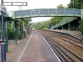
The first railway station at Ivybridge was not complete when the South Devon Railway was opened, but was brought into use six weeks later on 15 June 1848. The building was situated on the north side of the track, immediately to the west of Ivybridge Viaduct. Passenger trains were withdrawn on 2 March 1965. On 15 July 1994 a new station was opened on a new site costing £380,000, outside the town, to the east.[26] It is operated by Great Western Railway who run links to London Paddington, and from Exeter to Cornwall. The station is advertised as a Park and Ride for the nearby city of Plymouth, although the level of service is infrequent and sporadic.
The town has a bus service (X80) to Plymouth, Totnes and Torquay run by first First South West. Stagecoach South West operates an hourly route between Plymouth and Paignton, which includes Ivybridge as a primary stop.
Shopping
The shopping area is mainly along Fore Street, with some small shops and restaurants situated in the Glanvilles Mill shopping centre which is accessible from Fore Street. The shopping centre contains over 35 shops including the bistro/restaurant The Riverbank, a number of charity shops, Nature's Larder health store and therapy centre, a post office, a hair salon, several estate agents, a Co-operative Food store and a Warrens Bakery. The town's closest superstore is a Tesco Extra in the neighbouring village of Lee Mill. There is also a garden centre known as Endsleigh just outside the town.
Education

The town has six schools: Four state primary schools, the Dame Hannah Roger's special school, and Ivybridge Community College, the town's secondary state school, which has a sixth form. It has specialist status as a sports college and has recently been given awards in science and mathematics as well as languages.[27] The school has a very large catchment area which stretches from Shaugh Prior on Dartmoor, to Bigbury on the coast and covers many of the villages in the South Hams such as Ugborough, Modbury and Yealmpton. There are no independent schools in Ivybridge, but Dame Hannah Rogers School provides a boarding education for children with disabilities and communication needs. The nearest university is the University of Plymouth. The town also has a youth centre. In 2008 a new library and resource centre called the Watermark was opened, replacing the small library on Keaton Road. There are two notable people from the community college: sports teacher Michaela Breeze who won a gold medal weightlifting in the 2002 Commonwealth Games for Wales and won another gold medal in the 2006 Commonwealth Games.[28][29] and the school's former principal – Geoffrey Rees now retired, who was given a CBE for his services to education.[30]
Religion

Ivybridge has six churches. St John's Church (Anglican) is the parish church situated near the Ivy Bridge. There is also a Baptist church, a Methodist church, and Ivybridge Congregational Church. On the western outskirts of the town is a Roman Catholic church – St Austin's Priory. The Salvation Army Church is currently held at the former Ivybridge Youth Centre.[31][32]
In 2011, 65.1% of the population stated that they were Christian, 26.5% stated as no religion and 7.8% did not state their religion. Furthermore, there were a few people stating other religions: 0.3 (31 people) as other religions, 0.2% (18 people) stated as Buddhist, 0.1 (16 people) as Muslim, 0.1% (7 people) as Hindu, and one Jew.[33] Since 2001, there has been a shift from Christian (down 13 percentage points) to non-religious (up 12 points).[34]
Sports
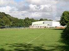
Each April the Ivybridge walking and outdoor festival takes place. There are various leisure facilities in the town: the South Dartmoor Leisure Centre features an indoor swimming pool, an outdoor swimming pool, an indoor sports hall, squash courts and gymnasium facilities. The South Devon Tennis Centre has four indoor and four outdoor courts. Next to the South Devon Tennis Centre are the Erme playing fields (Erme Valley) which hold a cricket field (with a practice net) and two football pitches. There is also a skatepark in the centre of the town and rugby pitches on the eastern outskirts of town at Ivybridge Rugby Football Club, a cricket team, and the Erme Valley Harriers (athletics and road running). The town's football team, called Ivybridge Town F.C., was founded in 1925 and play at region level in the South West Peninsula League.[35] The town's flat green bowls club is situated at the end of Bridge Park.
Public services

South West Water supply the town with water and sewage services. South Hams District Council is responsible for waste management. The town's Distribution Network Operator is Western Power Distribution. Currently the town along with the rest of Devon relies on electricity generated further north from the national grid, although Langage Power Station in Plympton is due to start generating electricity for the town as early as December 2008.[36] The town has two health centres: Ivybridge Health Centre and Highlands health centre, both located near the centre of the town.[37] It also has three dentist surgeries: Victoria House Dental Surgery, M L Brown and Highland Street Dental Practice.[38] Ivybridge is served by Plymouth Hospitals NHS Trust and the nearest hospital is Derriford Hospital in Plymouth. South Western Ambulance Service NHS Trust operates in Ivybridge and the rest of the south west; its headquarters are in Exeter. Devon and Cornwall Constabulary serve the town's policing matters and there is a small police station in the centre of the town. Ivybridge has one retained fire station (number 53) on the southern outskirts of town, which is in the west division of Devon as part of Devon and Somerset Fire and Rescue Service. It has a Water Tender Ladder, Prime Mover, Environmental Pod and an Incident Support Unit. The fire station used to be closer to the centre of the town. There is also a youth centre in the centre of the town which has just recently been was opened in 2007.
Notable residents
Born in 1847 in Ivybridge, Edmund Hartley was awarded a Victoria Cross in the Basuto Gun War. Local businessman and serial child rapist William Goad briefly resided in Ivybridge and changed his name in the 1990s to evade police, before fleeing to Thailand in 1998 under a false passport.[39]
See also
| Wikimedia Commons has media related to Ivybridge. |
- List of civil parishes in Devon
- List of schools in the South West of England
- United Kingdom Census 2001
References
- 1 2 3 "Key Figures for 2011 Census: Key Statistics". Office for National Statistics. Retrieved 18 July 2013.
- 1 2 "Ivybridge". Morris and Co.'s Commercial Directory and Gazetteer 1870. Retrieved 27 April 2008.
- 1 2 3 4 "Census statistics 1801–2001". Devon County Council. Retrieved 26 April 2008.
- ↑ Mann, Bob (1996). "Stowford". Ivybridge (PDF). Obelisk Publications. p. 7. ISBN 1-899073-46-9. Retrieved 28 April 2008.
- 1 2 "The Past and The Present". Ivybridge Town Council website. Archived from the original on 23 December 2007. Retrieved 27 April 2008.
- ↑ Hoskins, William George (1954). Devon. Phillimore & Company, Limited. ISBN 1-86077-204-8. Retrieved 28 June 2008.
- 1 2 "Ivybridge Town Council". Ivybridge Town Council website. Retrieved 24 January 2016.
- ↑ Local government in England and Wales: A Guide to the New System. London: HMSO. 1974. ISBN 0-11-750847-0.
- ↑ "Devon Town Baseline Profile" (PDF). Devon County Council. Retrieved 26 April 2008.
- ↑ "Council of the Year 2007". National Association of Local Councils. Retrieved 27 April 2008.
- ↑ Mann, Bob (1996). "Ivy Bridge". Ivybridge (PDF). Obelisk Publications. p. 10. ISBN 1-899073-46-9. Retrieved 30 April 2008.
- ↑ "South West Devon results 2015". BBC News Online. 8 May 2015. Retrieved 2 October 2015.
- ↑ "South West Devon constituency schedule" (PDF). South Hams District Council. Retrieved 27 April 2008.
- ↑ "Ivybridge International Links". Ivybridge Town Guide. Retrieved 27 April 2008.
- 1 2 "Climatological Information for Plymouth, United Kingdom". Hong Kong Observatory. Retrieved 27 April 2008.
- ↑ "Geological map of Great Britain". Stanford Geological Atlas (1904). Archived from the original on 25 March 2007. Retrieved 27 April 2008.
- 1 2 3 "About south-west England". The Met Office. Archived from the original on 25 February 2006. Retrieved 28 May 2006.
- ↑ "Ecoivy". Retrieved 7 January 2010.
- ↑ "The 2011 Census programme". Office for National Statistics. Retrieved 22 October 2015.
- ↑ "Census shows increase in population of the South West as it tops 5 million". Office for National Statistics. Retrieved 22 October 2015.
- ↑ "Parish Profile – People". Office for National Statistics. Retrieved 23 May 2008.
- ↑ "Age Structure, 2011". Office for National Statistics. Retrieved 22 October 2015.
- ↑ "Ethnic Group, 2011". Office for National Statistics. Retrieved 22 October 2015.
- ↑ "Customers can scan and go at new Ivybridge Library". Devon County Council. Archived from the original on 14 April 2008. Retrieved 27 April 2008.
- ↑ "The Watermark Business Centre". The Watermark. Retrieved 2 October 2015.
- ↑ Mann, Bob (1996). "Introduction". Ivybridge (PDF). Obelisk Publications. p. 3. ISBN 1-899073-46-9. Retrieved 28 April 2008.
- ↑ "About us (Ivybridge Community College)". Ivybridge Community College. Retrieved 27 April 2008.
- ↑ "Breeze claims medal hat-trick". BBC News Online. 31 July 2002. Retrieved 22 May 2008.
- ↑ "Breeze lands Welsh lifting gold". BBC News Online. 19 March 2006. Retrieved 22 May 2008.
- ↑ The London Gazette: (Supplement) no. 56797. p. 8. 31 December 2002. Retrieved 2 October 2015.
- ↑ "Ivybridge Salvation Army".
- ↑ "Religion and Spirituality in Ivybridge". Ivybridge Town Council website. Archived from the original on 12 November 2007. Retrieved 27 April 2008.
- ↑ "Religion, 2011". Office for National Statistics. Retrieved 22 October 2015.
- ↑ "Ivybridge Religion dataset". Office for National Statistics. Retrieved 27 April 2008.
- ↑ "Club History Ivybridge". Ivybridge Town F.C. Retrieved 27 April 2008.
- ↑ "Power plant gets go-ahead at last". BBC News Online. 16 June 2006. Retrieved 26 April 2008.
- ↑ "Doctors serving people in Ivybridge". Ivybridge Town Council website. Archived from the original on 28 August 2008. Retrieved 26 April 2008.
- ↑ "Dentists serving people in Ivybridge". Ivybridge Town Council website. Archived from the original on 15 August 2007. Retrieved 26 April 2008.
- ↑ Keenan, Shy; Payne, Sara (2009). "20". Where Angels Fear. London: Hodder & Stoughton. ISBN 978-0-340-93745-7.
External links
- Ivybridge Town Council
- Ivybridge Community Website
- The Watermark – Information Centre, Library & Innovation Centre
- Ivybridge at DMOZ
 |
Cornwood | Harford | Bittaford | |
| Lee Mill | |
Ugborough | ||
| ||||
| | ||||
| Yealmpton | Filham • Ermington | Modbury |