Indiana State Road 58
| ||||
|---|---|---|---|---|
 | ||||
| Route information | ||||
| Maintained by INDOT | ||||
| Length: | 122.07 mi[1] (196.45 km) | |||
| Existed: | October 1, 1926[2] – present | |||
| Major junctions | ||||
| West end: |
| |||
|
| ||||
| East end: |
| |||
| Location | ||||
| Counties: | Bartholomew, Greene Jackson, Knox, Lawrence, Daviess, Sullivan | |||
| Highway system | ||||
| ||||

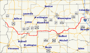
State Road 58 is an east–west road in Central Indiana. State Road 58 runs from Merom in the west to Columbus in the east, a distance of approximately 122 miles (196 km). Along its route it has concurrencies with one U.S. Route and six other Indiana state roads.
Route description
SR 58 western terminus is at State Road 63 (SR 63) in Merom. SR 58 heads south and east towards Carlisle. In Carlisle SR 58 has an intersection with U.S. Route 41/U.S. Route 150. SR 58 heads southeast from Carlisle towards Freelandville. In Freelandville SR 58 has an intersection with the northern terminus of State Road 159. East of Freelandville SR 58 heads east and has a concurrency with State Road 67 (SR 67). Then SR 58 heads east towards Elnora where SR 58 has a concurrency with State Road 57 (SR 57). SR 58 heads south after the concurrency with SR 57. South of Elnora SR 57 has an intersection with the eastern terminus of State Road 358 (SR 358). At SR 358, SR 58 heads due east towards U.S. Route 231 (US 231), passing through Odon. SR 58 has a concurrency with US 231, at the northern end of the concurrncy is also the western terminus of State Road 45 (SR 45). SR 45 and SR 58 heads east until SR 45 turns north. SR 58 heads east from the western end of the concurrncy with SR 45. SR 58 then has a concurrency with State Road 54 (SR 54). At the intersection with State Road 37 SR 54 ends and SR 58 follows SR 37 south toward Bedford. SR 58 passes through the north part of Bedford and then heads northeast towards Columbus. The western terminus of SR 58 is at an interchange with Interstate 65.[3]
History
Original SR 58 followed the same route State Road 156 follows in southeastern Indiana. Then route was changed to a route that follows the route of today and the route that State Road 158. SR 58 was reroute north to the route of today.
Major intersections
| County | Location | mi[1] | km | Destinations | Notes |
|---|---|---|---|---|---|
| Sullivan | Merom | 0.00 | 0.00 | Western terminus of SR 58 | |
| Carlisle | 13.56 | 21.82 | |||
| Knox | Freelandville | Northern terminus of SR 159 | |||
| Westphalia | 28.72 | 46.22 | Southern end of SR 67 concurrency | ||
| 30.02 | 48.31 | Northern end of SR 67 concurrency | |||
| Sandborn | 31.21 | 50.23 | Southern terminus of SR 59 | ||
| Daviess | Elnora | 36.53 | 58.79 | Western end of SR 57 concurrency | |
| 36.65 | 58.98 | Eastern end of SR 57 concurrency | |||
| Elmore Township | Eastern terminus of SR 358 | ||||
| I-69 exit 76. | |||||
| Madison Township | 47.64 | 76.67 | Southern end of US 231 concurrency | ||
| Western terminus of SR 558 | |||||
| Greene | Scotland | 52.33 | 84.22 | Northern end of US 231 concurrency; Western terminus and end of SR 45 concurrency. | |
| Jackson Township | 61.40 | 98.81 | Eastern end of SR 45 concurrency | ||
| Lawrence | Springville | 69.04 | 111.11 | Western end of SR 54 concurrency | |
| Avoca | 74.30 | 119.57 | Northern end of SR 37 concurrency; Eastern terminus and end of SR 54 concurrency | ||
| Bedford | 77.33 | 124.45 | Southern end of SR 37 concurrency | ||
| Heltonville | 88.88 | 143.04 | |||
| Jackson | Freetown | 103.61 | 166.74 | Southern end of SR 135 concurrency | |
| 104.87 | 168.77 | Northern end of SR 135 concurrency | |||
| Western terminus of SR 258 | |||||
| Bartholomew | Columbus | 122.07 | 196.45 | I-65 exit 64; eastern terminus of SR 58. | |
1.000 mi = 1.609 km; 1.000 km = 0.621 mi
| |||||
References
- 1 2 "INDOT Roadway Referencing System" (PDF).
- ↑ "Road Numbers to Be Changed". The Hancock-Democrat. The Indianapolis News. September 30, 1926. Retrieved June 9, 2016 – via Newspapers.com.

- ↑ Google (2011-02-28). "overview map of SR 58" (Map). Google Maps. Google. Retrieved 2011-02-28.