Crane, Indiana
| Crane, Indiana | |
|---|---|
| Town | |
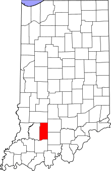 Martin County's location in Indiana | |
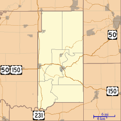 Crane, Indiana Crane's location in Martin County | |
| Coordinates: 38°53′34″N 86°54′5″W / 38.89278°N 86.90139°WCoordinates: 38°53′34″N 86°54′5″W / 38.89278°N 86.90139°W | |
| Country | United States |
| State | Indiana |
| County | Martin |
| Township | Perry |
| Area[1] | |
| • Total | 0.12 sq mi (0.31 km2) |
| • Land | 0.12 sq mi (0.31 km2) |
| • Water | 0 sq mi (0 km2) |
| Elevation | 610 ft (186 m) |
| Population (2010)[2] | |
| • Total | 184 |
| • Estimate (2012[3]) | 184 |
| • Density | 1,533.3/sq mi (592.0/km2) |
| Time zone | EST (UTC-5) |
| • Summer (DST) | EST (UTC-5) |
| ZIP code | 47522 |
| Area code(s) | 812 |
| FIPS code | 18-15652[4] |
| GNIS feature ID | 0433088[5] |
Crane is a town in Perry Township, Martin County, Indiana, United States. The population was 184 at the 2010 census. It was named in 1943 for William M. Crane and is adjacent to the Naval Surface Warfare Center Crane Division.[6]
Geography
Crane is located at 38°53′34″N 86°54′5″W / 38.89278°N 86.90139°W (38.892703, -86.901294).[7]
According to the 2010 census, Crane has a total area of 0.12 square miles (0.31 km2), all land.[1]
Major Highways
Demographics
| Historical population | |||
|---|---|---|---|
| Census | Pop. | %± | |
| 1970 | 339 | — | |
| 1980 | 297 | −12.4% | |
| 1990 | 216 | −27.3% | |
| 2000 | 203 | −6.0% | |
| 2010 | 184 | −9.4% | |
| Est. 2015 | 183 | [8] | −0.5% |
2010 census
As of the census[2] of 2010, there were 184 people, 80 households, and 43 families residing in the town. The population density was 1,533.3 inhabitants per square mile (592.0/km2). There were 109 housing units at an average density of 908.3 per square mile (350.7/km2). The racial makeup of the town was 96.7% White and 3.3% Asian.
There were 80 households of which 27.5% had children under the age of 18 living with them, 36.3% were married couples living together, 11.3% had a female householder with no husband present, 6.3% had a male householder with no wife present, and 46.3% were non-families. 43.8% of all households were made up of individuals and 13.8% had someone living alone who was 65 years of age or older. The average household size was 2.30 and the average family size was 3.12.
The median age in the town was 39.4 years. 26.1% of residents were under the age of 18; 5.4% were between the ages of 18 and 24; 25.5% were from 25 to 44; 26.7% were from 45 to 64; and 16.3% were 65 years of age or older. The gender makeup of the town was 48.4% male and 51.6% female.
2000 census
As of the census[4] of 2000, there were 203 people, 89 households, and 54 families residing in the town. The population density was 1,705.4 people per square mile (653.2/km²). There were 112 housing units at an average density of 940.9 per square mile (360.4/km²). The racial makeup of the town was 97.04% White, 0.49% Asian, and 2.46% from two or more races. Hispanic or Latino of any race were 0.49% of the population.
There were 89 households out of which 24.7% had children under the age of 18 living with them, 49.4% were married couples living together, 6.7% had a female householder with no husband present, and 39.3% were non-families. 31.5% of all households were made up of individuals and 12.4% had someone living alone who was 65 years of age or older. The average household size was 2.28 and the average family size was 2.93.
In the town the population was spread out with 27.1% under the age of 18, 2.0% from 18 to 24, 21.2% from 25 to 44, 28.6% from 45 to 64, and 21.2% who were 65 years of age or older. The median age was 44 years. For every 100 females there were 89.7 males. For every 100 females age 18 and over, there were 92.2 males.
The median income for a household in the town was $36,250, and the median income for a family was $45,625. Males had a median income of $33,750 versus $27,500 for females. The per capita income for the town was $16,853. About 9.6% of families and 13.6% of the population were below the poverty line, including 26.9% of those under the age of eighteen and 3.0% of those sixty five or over.
References
- 1 2 "G001 - Geographic Identifiers - 2010 Census Summary File 1". United States Census Bureau. Retrieved 2015-07-16.
- 1 2 "American FactFinder". United States Census Bureau. Retrieved 2012-12-11.
- ↑ "Population Estimates". United States Census Bureau. Archived from the original on June 17, 2013. Retrieved 2013-06-25.
- 1 2 "American FactFinder". United States Census Bureau. Archived from the original on September 11, 2013. Retrieved 2008-01-31.
- ↑ "US Board on Geographic Names". United States Geological Survey. 2007-10-25. Retrieved 2008-01-31.
- ↑ Rund, Christopher; Frailey, Fred W.; Powell, Eric (September 2011). The Indiana Rail Road Company: America's New Regional Railroad. Indiana University Press. p. 264. ISBN 0-253-35695-4.
- ↑ "US Gazetteer files: 2010, 2000, and 1990". United States Census Bureau. 2011-02-12. Retrieved 2011-04-23.
- ↑ "Annual Estimates of the Resident Population for Incorporated Places: April 1, 2010 to July 1, 2015". Retrieved July 2, 2016.
- ↑ "Census of Population and Housing". Census.gov. Archived from the original on May 11, 2015. Retrieved June 4, 2015.
Municipalities and communities of Martin County, Indiana, United States | ||
|---|---|---|
| City | ||
| Towns | ||
| Townships | ||
| CDPs | ||
| Other unincorporated communities | ||