Incapillo
| Incapillo | |
|---|---|
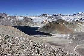 View inside the caldera | |
| Highest point | |
| Elevation | 5,750 m (18,860 ft) [1] |
| Coordinates | 27°53′24″S 68°49′12″W / 27.89000°S 68.82000°WCoordinates: 27°53′24″S 68°49′12″W / 27.89000°S 68.82000°W ,[2] with conversion. |
| Geography | |
 Incapillo The South American country of Argentina | |
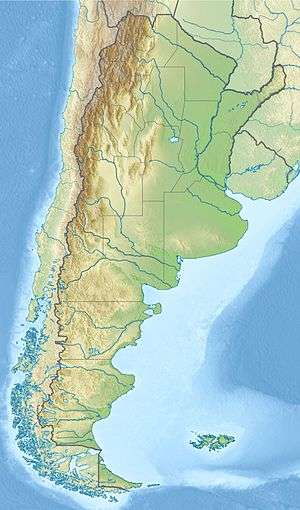
| Location | Central Argentina |
| Parent range | Andes |
| Geology | |
| Age of rock | Pleistocene |
| Mountain type | Caldera |
| Volcanic belt | Andean Volcanic Belt |
| Last eruption | <0.52 ± 0.03-0.51 ± 0.04 mya |
Incapillo is a Pleistocene caldera, a depression formed by the collapse of a volcano, in the La Rioja province of Argentina. Part of the Argentine Andes, it is considered the southernmost volcanic centre in the Central Volcanic Zone of the Andes with Pleistocene activity. Incapillo is one of several ignimbritic or calderic systems that, along with 44 active stratovolcanoes, are part of the Central Volcanic Zone.
Subduction of the Nazca Plate beneath the South America plate is responsible for most of the volcanism in the Central Volcanic Zone. After activity in the western Maricunga Belt volcanic arc ceased six million years ago, volcanism started up in the Incapillo region, forming the high volcanoes Monte Pissis, Cerro Bonete Chico and Sierra de Veladero. Later, a number of lava domes formed between these volcanoes.
Incapillo is the source of the Incapillo ignimbrite, a medium-sized deposit comparable to the Katmai ignimbrite. With a volume of about 20.4 cubic kilometres (4.9 cu mi), the Incapillo ignimbrite was erupted 0.52 ± 0.03 and 0.51 ± 0.04 million years ago. A caldera with dimensions of 5 by 6 kilometres (3.1 mi × 3.7 mi) was formed during the eruption. Later volcanism generated more lava domes within the caldera and a debris flow in the Sierra de Veladero. The lake within the caldera may overlie an area of ongoing hydrothermal activity.
Geography and structure
Incapillo is located in Argentina's La Rioja province.[3] The name "Incapillo" means "Crown of the Inca" in Quechua and is the highest caldera stemming from explosive activity in the world.[4] It is also known as Bonete caldera.[2]
Incapillo is part of the Andean Central Volcanic Zone, which extends through the countries of Chile, Bolivia, and Argentina and includes six or more Quaternary caldera or ignimbrite systems, about 44 stratovolcanoes, and over 18 smaller centres. One of these stratovolcanoes, Ojos del Salado, is the world's highest volcano.[5] This zone also includes the Altiplano-Puna volcanic complex and the Galan caldera farther south.[4] Incapillo is the southernmost volcano of the Central Volcanic Zone with Pleistocene activity; the next such volcano to the south is Tupungato in the Southern Volcanic Zone at 33° southern latitude.[6]
Incapillo is a caldera with a diameter of 5 by 6 kilometres (3.1 mi × 3.7 mi) at an elevation of 5,750 metres (18,860 ft).[1] The three adjacent volcanic centres of Monte Pissis (6,882 metres (22,579 ft)), Cerro Bonete Grande (6,436 metres (21,115 ft)), and Cerro Bonete Chico (6,759 metres (22,175 ft)) are also considered part of this volcanic complex and are among the highest on Earth.[7] These centres surround the ignimbrite and lava domes.[4] The walls of the caldera are 250 metres (820 ft) high.[2] A uniform ignimbrite, called the Incapillo ignimbrite, is rich in pumice and forms the bulk of the caldera walls.[4]
Around the caldera lie 40 lava domes,[1] which extend northwest-southeast.[6] There is an eastern group between Monte Pissis and Cerro Bonete Chico and a western one on the Sierra de Veladero. Overall, the domes have heights of 100–600 metres (330–1,970 ft) and a basal apron of about 1 kilometre (0.62 mi) width of erosional material. Some domes have water-filled craters with widths of 20 metres (66 ft) at their top. Domes on the caldera's northern side are dacitic and show signs of alteration. Some domes are probably part of the pre-caldera complex, and several rhyodacitic domes were modified by erosional processes after caldera formation; these were formerly considered erosional remnants. Older domes have reddish oxidized colours in satellite images. The total volume of the domes is about 16 cubic kilometres (3.8 cu mi).[4]
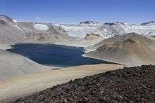
Next to a heavily hydrothermally altered lava dome in the centre of the caldera lies the Laguna Corona del Inca.[4] This 350 metres (1,150 ft) deep and 5,300 metres (17,400 ft) high lake measures 2 by 1 kilometre (1.24 mi × 0.62 mi).[8] The lake has probably generated the evaporite and lacustrine deposits that lie on the caldera floor. Water temperatures of 13 °C (55 °F) obtained by satellite measurements suggest that some hydrothermal activity persists.[4] The lake is fed by meltwater.[8]
Geology
The Nazca plate subducts beneath the South America plate at a speed of 7–9 centimetres (2.8–3.5 in) per year in the area of the Central Volcanic Zone. The subduction results in volcanism along the occidental Cordillera 240–300 kilometres (150–190 mi) east of the trench formed by the subduction.[5]
Incapillo is one of at least six different ignimbrite or caldera volcanoes that are part of the Central Volcanic Zone, in Chile, Bolivia and Argentina. The Central Volcanic Zone is one of four different volcanic arcs in the Andes.[5] About 50 kilometres (31 mi) west of Incapillo lies the Maricunga Belt, where volcanism started 27 mya and involved phases of ignimbritic and stratovolcanic activity, including Copiapo volcano, until activity ceased with the last eruption of Nevado de Jotabeche 6 mya.[4] South of Incapillo, the Pampean flat slab region is associated with tectonic deformation and lack of volcanic activity until Tupungato volcano farther south.[4]
S. L. de Silva and P. Francis suggested in their 1991 book Volcanoes of the Central Andes that the Central Volcanic Zone should be subdivided into two systems of volcanoes, one in Peru and another in Chile, on the basis of the orientation (northwest–southeast versus north–south). C.A. Wood, G. McLaughlin and P. Francis in a 1987 paper at the American Geophysical Union suggested instead a subdivision into nine different groups.[5]
Local
Incapillo is found on a crust 70 kilometres (43 mi) thick, among the thickest in volcanic regions of the Earth.[4] Several studies by Suzanne Mahlburg Kay and others indicate that trends in the isotope ratios are because of a thickening crust and increased contribution thereof to the magmas. At the latitude of Incapillo, the northern Antofalla terrane borders the Cuyania terrane, both of which were attached to South America during the Ordovician but are of different provenance.[6]
At the latitude of Incapillo, the Nazca plate subducting beneath the South America plate abruptly shallows towards the south. This shallowing forms the limit between the volcanically active Central Volcanic Zone and the magmatically inactive Pampean flat slab region farther south.[9] This magmatic inactivity occurs because the flat slab removes the asthenospheric wedge.[3]
Incapillo is part of a volcanic system active between 3.5 and 2 mya that includes Ojos del Salado and Nevado Tres Cruces. It was the last volcanic centre formed in the region; subsequently, the shallowing of the subducting slab prevented volcanism east and south of it.[6] Another volcanic trend considers Incapillo as part of a northeast–southwest trend with Cerro Galan and Cerro Blanco. This trend may be related to delamination of the lower crust. Also, these centres are located between two domains of different rigidity, an Ordovician sedimentary domain of low rigidity and a higher rigidity basement.[2]
The formation of the older lava domes may have been influenced by buried faults or the supply systems of the older Pissis and Bonete Chico volcanoes.[4] Isotope and composition data suggest that the magma of Incapillo forms at relatively constrained depths of c. 65–70 kilometres (40–43 mi) above the shallow slab.[6] A focus of seismic activity is found at Incapillo.[9]
Composition
The Incapillo ignimbrite is formed by potassium-rich and magnesium-poor rhyodacite, forming glassy and porous pumice with individual clasts of 5–20 centimetres (2.0–7.9 in) in diametre. Typical pumice contains crystals of biotite, hornblende, plagioclase, quartz, and sanidine, with minor amounts of apatite, iron oxides, and titanite. The lava domes have uniform crystalline compositions that are richer in magnesium than the ignimbrite. Within the lava dome rocks lie phenocrysts of amphibole, biotite, plagioclase, quartz, and titanite with some alkali feldspar in some domes. Older domes have higher amphibole and lower quartz content than younger domes. Post-caldera domes are strongly hydrothermally altered.[4]
Rocks from Incapillo are rich in sodium and have high ratios of lanthanum and samarium to ytterbium and high ratios of barium to lanthanum, as well as high lead-206 to lead-204 and strontium-87/strontium-86 ratios.[6] These rare earth element patterns are similar to the Late Miocene Maricunga Belt rocks and contrast to early Miocene rocks. The changes occurred at the same time as the arc migrated eastward, terminating activity in the Maricunga Belt.[3] The element ratios are pronouncedly arc-like with some adakitic signatures. The rocks contain considerably more sodium and alumina than almost all Central Andes siliceous volcanic rocks.[10]
The composition of the lava domes suggests that they were formed by degassed magma left behind by the caldera-forming eruption.[11] The pre-caldera lava domes were generated either directly from a common magma chamber or indirectly through secondary chambers.[4] The lead isotope ratios are consistent with the volcano having formed at the edge of an area of granite and rhyolite of Paleozoic age.[6] Incapillo magmas probably formed as adakitic high-pressure mafic magmas derived from the crust, either directly by anatexis or indirectly by dragged-down crustal fragments. The magmas are then modified by crustal contamination and fractional crystallization.[10] As the subducting slab shallowed, crustal garnet-containing lherzolite and granulite-eclogite, contributed both from the crustal basis and forearc rocks that were dragged down by the subducting slab, became an increasingly important component of erupted magmas.[3] Eventually, the Incapillo magma chamber was disconnected from the mantle and lower crust.[10]
The Incapillo ignimbrite contains xenoliths with sizes of 0.5–4 centimetres (0.20–1.57 in) formed by amphibolite. Amphibole crystals are enclosed in intersitital plagioclase crystals and sometimes contain secondary biotite crystals. Amphibole is the dominant component.[10]
Climate, hydrology and vegetation
Incapillo as a high altitude location has an alpine climate, with low temperatures and low oxygen, high winds and predominantly summer precipitation. Incapillo itself has no weather stations and thus climate data from there are not available, however Laguna Brava farther south has an average precipitation of 300 millimetres (12 in) and temperatures of 0–5 °C (32–41 °F). The Desaguadero River originates on Bonete.[8]
Vegetation varies depending on the water supply and altitude of the site, with an upper altitude limit of 4,300–5,000 metres (14,100–16,400 ft) beneath of which the vegetation takes the form of a scrub steppe. Grasses at 5,000 metres (16,000 ft) include Festuca, Stipa and in wetter areas also genera like Calamagrostis. Scrub like Adesmia and Nototriche copon occasionally form dense scrub patches.[8]
History
Activity at Incapillo commenced shortly after the end of the Maricunga Belt volcanism and occurred first at Monte Pissis between 6.5 and 3.5 mya. Later volcanism occurred south of Incapillo 4.7±0.5 mya, at Sierra de Veladero 5.6±1–3.6±0.5 mya, and in the region of Cerro Bonete Chico 5.2±0.6–3.5±0.1 mya.[3] Some of the 3–2 mya Pircas Negras mafic andesites appear to be associated with the Incapillo volcanic complex. These rocks form the last pulse of the Pircas Negras volcanism.[12] Specific ages of the Pircas Negras flows in the Incapillo region include 4.7±0.5 mya, 3.2±0.3 mya and 1.9±0.2 mya. Later, andesitic-rhyolitic volcanism formed ignimbrites and lava domes 2.9±0.4–1.1±0.4 mya,[3] with the youngest pre-caldera dome being 0.873±0.077 mya old. The lava domes formed through non-explosive extrusion.[4]
The Incapillo ignimbrite is an unwelded ignimbrite[4] that covers a surface area of 80.47 square kilometres (31.07 sq mi), extending to a distance of 15 kilometres (9.3 mi) from the caldera.[2] The ignimbrite appears in an eastward-heading ephemeral river valley and the southern Quebrada del Veladero, possibly also next to the Rio Salado headwaters. Thicknesses range from 250 to 10 metres (820 to 33 ft); the ignimbrite is underlain by a lithic-and-ash rich surge deposit with a thickness of 5 centimetres (2.0 in). The ignimbrite displays banding features away from the caldera and in Quebrada de Veladero football-sized clasts are mixed within fine ash. Rocks from the ignimbrites farther away from their source indicate the ignimbrite probably formed from the mixing of less viscous dacitic magma with rhyolite.[4] The total volume of the ignimbrite is about 20.4 cubic kilometres (4.9 cu mi). Ages have been found of 0.52 ± 0.03 and 0.51 ± 0.04 mya ago. It is a rhyodacitic to rhyolitic ignimbrite with a high crystal and pumice[2] and low lithic content.[4] The dense rock equivalent volume is about 14 cubic kilometres (3.4 cu mi).[10] The volume of the Incapillo ignimbrite is comparable to that of the Katmai ignimbrite. The ignimbrite was probably formed from a low-height fountaining eruption without a high eruption column, forming a base surge first and pyroclastic flows later. The change from lava dome to ignimbrite-forming eruptions may have been triggered by the injection of hotter magmas into the magma chamber or less likely by changes in the tectonic context. During the eruption, a piston-like collapse formed the caldera.[4]
Later, a debris flow named Veladero (also known as Quebrada de Veladero Ignimbrite) occurred in a glacier valley south of the caldera. It is rich in lithics and pumice.[2] These lithics are derived from Sierra de Veladero, Cerro Bonete Chico, and Pircas Negras lavas. The debris flow ranges from 15 to 25 metres (49 to 82 ft) in thickness 5 kilometres (3.1 mi) south of the caldera to 10 to 15 metres (33 to 49 ft) farther south, the total volume being 0.7–0.5 cubic kilometres (0.17–0.12 cu mi). The debris flow does have a different composition from the main Incapillo ignimbrite, as it contains red-brown dacite and clasts. It has a massive ungraded composition and is likely a lahar or debris flow deposit, probably influenced by glacial or crater lake water. Wind-driven effects have generated hummocky ridges.[4]
There are no dates available for post-caldera lava domes, which probably arose from magma ascending through the caldera forming conduits, seeing as these domes are found only inside the caldera. The elevated temperatures of the caldera lake suggest that hydrothermal activity still occurs beneath Incapillo.[4]
References
- 1 2 3 "Incapillo". Global Volcanism Program. Smithsonian Institution.
- 1 2 3 4 5 6 7 Guzmán, Silvina; Grosse, Pablo; Montero-López, Carolina; Hongn, Fernando; Pilger, Rex; Petrinovic, Ivan; Seggiaro, Raúl; Aramayo, Alejandro (December 2014). "Spatial–temporal distribution of explosive volcanism in the 25–28°S segment of the Andean Central Volcanic Zone". Tectonophysics. 636: 170–189. doi:10.1016/j.tecto.2014.08.013.
- 1 2 3 4 5 6 Kay, S.M.; Mpodozis, C. (2000). "Chemical signatures from magmas at the southern termination of the Central Andean Volcanic Zone: the Incapillo/Bonete and surrounding regions" (PDF). biblioserver.sernageomin.cl. Puerto Varas: IX Chilean Geological Congress. pp. 626–629. Archived from the original (PDF) on 22 May 2016. Retrieved 22 May 2016.
- 1 2 3 4 5 6 7 8 9 10 11 12 13 14 15 16 17 18 19 20 Goss, A.R.; Kay, S.M.; Mpodozis, C.; Singer, B.S. (July 2009). "The Incapillo Caldera and Dome Complex (∼28° S, Central Andes): A stranded magma chamber over a dying arc". Journal of Volcanology and Geothermal Research. 184 (3–4): 389–404. doi:10.1016/j.jvolgeores.2009.05.005.
- 1 2 3 4 Stern, Charles R. (December 2004). "Active Andean volcanism: its geologic and tectonic setting". Revista geológica de Chile. 31 (2). doi:10.4067/S0716-02082004000200001.
- 1 2 3 4 5 6 7 Kay, S. M.; Mpodozis, C.; Gardeweg, M. (7 August 2013). "Magma sources and tectonic setting of Central Andean andesites (25.5–28 S) related to crustal thickening, forearc subduction erosion and delamination". Geological Society, London, Special Publications. 385 (1): 303–334. doi:10.1144/SP385.11.
- ↑ Goss, A.R.; Kay, S.M. (December 2003). "Termination of a Central Andean arc: The Chemical Evolution of the Bonete-Incapillo Volcanic Complex, Argentina". The SAO/NASA Astrophysics Data System. Ithaca, NY: American Geophysical Union, Fall Meeting 2003. Retrieved 22 May 2016.
- 1 2 3 4 Morello, J; Matteucci, S.D.; Rodriguez, A.; Silva, M. (January 2012). "1". Ecorregiones y Complejos Ecosistémicos Argentinos (PDF) (in Spanish). Buenos Aires: Orientación Gráfica Editora. pp. 33–36. ISBN 978-987-1922-00-0. Retrieved 15 June 2016.
- 1 2 Mulcahy, Patrick; Chen, Chen; Kay, Suzanne M.; Brown, Larry D.; Isacks, Bryan L.; Sandvol, Eric; Heit, Benjamin; Yuan, Xiaohui; Coira, Beatriz L. (August 2014). "Central Andean mantle and crustal seismicity beneath the Southern Puna plateau and the northern margin of the Chilean-Pampean flat slab". Tectonics. 33 (8): 1636–1658. doi:10.1002/2013TC003393.
- 1 2 3 4 5 Goss, A. R.; Kay, S. M.; Mpodozis, C. (15 May 2010). "The geochemistry of a dying continental arc: the Incapillo Caldera and Dome Complex of the southernmost Central Andean Volcanic Zone (~28°S)". Contributions to Mineralogy and Petrology. 161 (1): 101–128. doi:10.1007/s00410-010-0523-1.
- ↑ Garrison, Jennifer M.; Reagan, Mark K.; Sims, Kenneth W. W. (June 2012). "Dacite formation at Ilopango Caldera, El Salvador: U-series disequilibrium and implications for petrogenetic processes and magma storage time". Geochemistry, Geophysics, Geosystems. 13 (6): n/a–n/a. doi:10.1029/2012GC004107.
- ↑ Goss, A.R.; Kay, S.M. (March 2009). "Extreme high field strength element (HFSE) depletion and near-chondritic Nb/Ta ratios in Central Andean adakite-like lavas (~28°S, ~68°W)". Earth and Planetary Science Letters. 279 (1–2): 97–109. doi:10.1016/j.epsl.2008.12.035.