Mount Katmai
| Mount Katmai | |
|---|---|
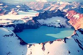 Mount Katmai and its crater lake in September 1980. | |
| Highest point | |
| Elevation | 6,716 ft (2,047 m) |
| Coordinates | 58°16′43.0″N 154°57′24.9″W / 58.278611°N 154.956917°W |
| Geography | |
| Location | Katmai National Park and Preserve, Alaska, United States |
| Parent range | Aleutian Range |
| Topo map | USGS Mount Katmai B-3 |
| Geology | |
| Mountain type | Stratovolcano |
| Volcanic arc/belt | Aleutian Arc |
| Last eruption | June to July 1912[1] |
| Climbing | |
| Easiest route | basic snow/ice climb |
Mount Katmai is a large stratovolcano (composite volcano) on the Alaska Peninsula in southern Alaska, located within Katmai National Park and Preserve. It is about 6.3 miles (10 km) in diameter with a central lake-filled caldera about 3 by 2 mi (4.5 by 3 km) in area, formed during the Novarupta eruption of 1912. The caldera rim reaches a maximum elevation of 6,716 feet (2,047 m). In 1975 the surface of the crater lake was at an elevation of about 4,220 feet (1,286 m), and the estimated elevation of the caldera floor is about 3,400 ft (1,040 m). The mountain is located in Kodiak Island Borough, very close to its border with Lake and Peninsula Borough.
Geology
Mount Katmai is one of five vents encircling the Novarupta volcano, source of the VEI 6 eruption and associated voluminous pyroclastic flows in 1912. The volcano has caused ten known fatalities due to gas exposure. Katmai consists chiefly of lava flows, pyroclastic rocks, and non-welded to agglutinated air fall. The Quaternary volcanic rocks at Katmai and adjacent cones are less than 5,000 ft (1,500 m) thick. Much of the volcano is mantled by snow and ice and several valley glaciers radiate out from the flanks.
Katmai volcano is built on the sedimentary rocks of the Naknek Formation of Late Jurassic age, which are exposed just west of the caldera rim at an elevation of about 5,000 feet (1,520 m), as well as north and southeast of the crater. Sedimentary rocks have been reported at an elevation of over 6,000 feet (1,830 m) in the west wall of the caldera and near the bottom of the eastern wall near 3,400 ft (1,040 m).
Volcanic activity
Little is known about the historical activity of Katmai volcano before the great 1912 eruption. Early U.S. Coast and Geodetic Survey maps suggest a pre-caldera summit elevation of about 7,500 ft (2,300 m), and local villagers reported in 1898 that one of the volcanoes in the general area "smoked" occasionally.
During June 6 to 9, 1912, the most spectacular Alaskan eruption in recorded history and the twentieth century's largest measured volcanic eruption resulted in the formation of a large summit caldera at Katmai volcano.[2][3] The eruption actually took place at a vent about 6 mi (10 km) to the west of Mount Katmai (at the Novarupta Volcano). During over 60 hours, the volcano erupted an estimated 28 km³ of ash flows and tephra representing 13 km³ of magma volume.[4] The eruption produced a cloud of suffocating gas and ash that blackened the sky for the inhabitants of the town of Kodiak, who with ash falling down on them were quickly led to the harbour and evacuated by boat.[5] The withdrawal of magma beneath Katmai resulted in the collapse of the summit area, forming the caldera. Following the subsidence, a small dacitic lava dome known as Horseshoe Island was emplaced on the floor of the caldera; this is the only juvenile material erupted from Katmai caldera during the historical eruption. It was visible at the time of the expedition in 1916, but has since been submerged by the crater lake. Still, the eruption from Katmai had a VEI of 3, and possibly involved phreatic eruptions.[6]
In 1919, geologists noted a lake covering a large part of the caldera floor, but by 1923 the lake was gone and numerous fumaroles, mud pots, and a large mud geyser had replaced it. The lake has since refilled to a depth of over 800 ft (240 m). Small glaciers have also formed on a bench within the caldera beside the lake. Pumice still floats on Naknek Lake nearby.[7]
See also
References
- ↑ "Katmai - Historic eruptions". Avo.alaska.edu. Retrieved 2013-11-22.
- ↑ Martin, George C. (February 1913). "The Recent Eruption of Katmai Volcano in Alaska". National Geographic Magazine. 24 (2): 131–181.
- ↑ "The Eruption of the Katmai Volcano, Alaska, on June 6, 1912". Nature. 91 (2271): 253. 8 May 1913.
- ↑ "Alaska Volcano Observatory - Katmai". Avo.alaska.edu. Retrieved 2013-11-22.
- ↑ Erskine
- ↑ "Global Volcanism Program | Katmai". Volcano.si.edu. Retrieved 2013-11-22.
- ↑ Noted by John Harte, The Green Fuse: an ecological odyssey, 1993:23.
Other sources
- "Katmai". Global Volcanism Program. Smithsonian Institution. Retrieved 2009-01-01.
- Alaska Volcano Observatory: Katmai
- Wood, Charles A.; Kienle, Jürgen, eds. (1990). Volcanoes of North America. Cambridge University Press. pp. 354 pp. ISBN 0-521-43811-X.
Further reading
- Erskine, Wilson Fiske. (1965). Katmai. A narrative of the eruption of June 1912 and its effects on the town of Kodiak and its community, taken from letters, diaries and notes written at the time. London, New York and Toronto: Abelard-Schuman.
- Hildreth, W., J. Fierstein, and J.E. Robinson. (2003). Geologic map of the Katmai Volcanic Cluster, Katmai National Park, Alaska [Geologic Investigations Series Map I-2778]. Reston, VA: U.S. Department of the Interior, U.S. Geological Survey.