Huttoft
| Huttoft | |
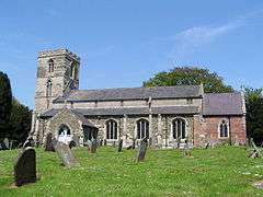 St Margaret's Church, Huttoft |
|
 Huttoft |
|
| Population | 585 (2011)[1] |
|---|---|
| OS grid reference | TF513764 |
| – London | 120 mi (190 km) S |
| District | East Lindsey |
| Shire county | Lincolnshire |
| Region | East Midlands |
| Country | England |
| Sovereign state | United Kingdom |
| Post town | Alford |
| Postcode district | LN13 |
| Police | Lincolnshire |
| Fire | Lincolnshire |
| Ambulance | East Midlands |
| EU Parliament | East Midlands |
| UK Parliament | Louth and Horncastle |
|
|
Coordinates: 53°15′48″N 0°16′03″E / 53.263434°N 0.267533°E
Huttoft is a small village in the East Lindsey district of Lincolnshire, England. It is situated approximately 4 miles (6 km) east from the market town of Alford, and on the A52 road between Ingoldmells and Sutton-on-Sea.
Etymology
Huttoft is listed three times in the 1086 Domesday Book as Hotoft,[2] in the manors of both Huttoft and Greetham in the Calcewath Hundred of the South Riding of Lindsey. The combined listings record over 19 households, and 20 villagers, 23 smallholders, 69 freemen, 20 ploughlands, and meadows of 860 acres (3.5 km2). Before the Norman Conquest Earl Harold was lord of Greetham; this in 1086 transferred to Earl Hugh of Chester who also became tenant-in-chief to King William I. The 1086 tenant-in-chief of Huttoft was Alfred of Lincoln.[3]
Huttoft is an Anglo-Norse place name derived from Old English hoh "decline", "slope" and Old Norse topt "site of a house". However, the Dictionary of British Place Names defines Huttoft as a "homestead on a spur of land."[4] De Beaurepaire states that it is the same name as the Hottot; Hotot (f. e. Hotot-en-Auge) ; Hautot (former Hotot. f. e. Hautot-sur-Seine) in Normandy.[5]
Landmarks
St Margaret's Church is built of stone in the decorated style,[6] and is a Grade I listed building. Built of greenstone, limestone, and with some brick patching, Restorations took place in 1869, 1882, and 1910. The west tower is 13th-century, although it was extended in the 14th century. The font is 15th-century, although the cover is 19th-century.[7] The churchyard cross, is a Grade II listed structure,[8] which was restored in 1896 with the addition of a crucifix.[9]
The Wesleyan Methodist chapel on Sutton Road, Huttoft, became part of the Alford, Skegness and Wainfleet Methodist Circuit in 1997.[10]
The Primitive Methodists also had a chapel in Church Lane, which was on the Alford Methodist circuit until 1963, and has since been demolished although the graveyard remains.[11]
Huttoft windmill is situated in the centre of the village and is a Grade II listed building.[12] It lost its sails in 1945 in a storm after a century of milling.[13]
Huttoft School was built as a National School in 1840, and was enlarged in 1874. It was known as Huttoft CE School by 1914, and became Huttoft County Primary in 1947. It became a Grant Maintained school and has been known as Huttoft Primary (GM) School since 1999.[14]
Situated about 2.5 miles (4.0 km) east, Huttoft Bank Pit is a nature reserve protected by the Lincolnshire Wildlife Trust. It provided clay for repairs to the sea bank after the North Sea flood of 1953. There is a large open water area and extensive reedbeds.[15] Huttoft Bank leads to Huttoft Beach, also known as Moggs Eye.[16]
Huttoft is the location of the Radcliffe Donkey Sanctuary.
Gallery
 Moggs Eye
 Primitive Methodist cemetery
 Huttoft sign
Population
| Population of Huttoft Civil Parish | ||||||||||||||||
|---|---|---|---|---|---|---|---|---|---|---|---|---|---|---|---|---|
| Year | 1801 | 1811 | 1821 | 1831 | 1841 | 1851 | 1881 | 1891 | 1901 | 1911 | 1921 | 1931 | 1951 | 1961 | 2001 | 2011 |
| Population[17] | 286 | 340 | 401 | 470 | 515 | 586 | 597 | 535 | 469 | 468 | 458 | 461 | 448 | 404 | 546 | 585 |
 |
Hannah cum Hagnaby, Maltby le Marsh, Louth | Sutton on Sea, Trusthorpe, Mablethorpe | Sandilands (resort) | |
| Bilsby, Alford, Baumber | |
Anderby Creek | ||
| ||||
| | ||||
| Farlesthorpe, Ulceby, Horncastle | Mumby, Cumberworth, Skegness | Chapel St Leonards, Ingoldmells |
References
- ↑ "Parish population 2011". Retrieved 18 August 2015.
- ↑ Albert Hugh Smith, English Place-names Elements, 2 volumes, Cambridge, 1972.
- ↑ "Huttoft". Domesday Map. Ann Powell-Smith/University of Hull. Retrieved 23 August 2011.
- ↑ Mills, Anthony David (2003); A Dictionary of British Place Names, Oxford University Press, revised edition (2011), p.252. ISBN 019960908X
- ↑ de Beaurepaire, François; Les noms des communes et anciennes paroisses de la Seine-Maritime, éditions Picard 1979. p. 92. ISBN 2708400401
- ↑ "Kellys Directory" (PDF). Kellys Directories Ltd. 1919. p. 808. Retrieved 24 April 2011.
- ↑ "St Margarets Church". National Heritage List for England. English Heritage. Retrieved 23 August 2011.
- ↑ "Cross in Churchyard, South Side, Huttoft". British Listed Buildings. Retrieved 25 April 2011.
- ↑ "Churchyard Cross, St Margarets". National Heritage List for England. English Heritage. Retrieved 23 August 2011.
- ↑ "Wesleyan Methodist Chapel, Huttoft". Lincs to the Past. Lincolnshire Archives. Retrieved 23 August 2011.
- ↑ "Huttoft Primitive Methodist Chapel". Lincs to the Past. Lincolnshire Archives. Retrieved 23 August 2011.
- ↑ "Huttoft Mill, Huttoft". British Listed Buildings. Retrieved 25 April 2011.
- ↑ "Time Travel Britain". Retrieved 24 April 2011.
- ↑ "Huttoft School". Lincs to the Past. Lincolnshire Archives. Retrieved 23 August 2011.
- ↑ "Lincolnshire Wildlife Trust". Retrieved 24 April 2011.
- ↑ "Huttoft Beach". Retrieved 24 April 2011.
- ↑ "Vision of Britain". Retrieved 23 August 2011.
External links
 Media related to Huttoft at Wikimedia Commons
- Website of the Radcliffe Donkey Sanctuary
England Portal | |
| Unitary authorities | |
| Boroughs or districts | |
| Major settlements |
|
| Topics | |