Bolingbroke, Lincolnshire
| Old Bolingbroke | |
 Old Bolingbroke |
|
 Old Bolingbroke |
|
| Population | 325 (2011) |
|---|---|
| OS grid reference | TF348651 |
| – London | 115 mi (185 km) S |
| Civil parish | Bolingbroke |
| District | East Lindsey |
| Shire county | Lincolnshire |
| Region | East Midlands |
| Country | England |
| Sovereign state | United Kingdom |
| Post town | Spilsby |
| Postcode district | PE23 |
| Dialling code | 01790 |
| Police | Lincolnshire |
| Fire | Lincolnshire |
| Ambulance | East Midlands |
| EU Parliament | East Midlands |
| UK Parliament | Louth and Horncastle |
| Website | Bolingbroke Parish Council |
|
|
Coordinates: 53°10′00″N 0°00′58″E / 53.1666°N 0.0160°E
Bolingbroke, now called Old Bolingbroke, is a village and civil parish in the East Lindsey district of Lincolnshire, England.[1][2] The population at the 2001 census was 298 in 128 households.[3] The parish population at the census 2011 had risen to 325.[4]
Bolingbroke is 3 miles (5 km) west of Spilsby. The village of New Bolingbroke is 6 miles (9.7 km) to the south-west. The Prime Meridian passes through the parish to the west of Old Bolingbroke.[5]
History

Bolingbroke appears in the Domesday survey as "Bolingborg",[6] one of 38 places associated with Stori of Bolingbroke at the time of the Norman conquest.[7]
William de Roumare, Earl of Lincoln (born circa 1096), built Old Bolingbroke Castle in the 12th century as a motte and bailey castle with wet ditch. In the early 13th century a new castle was constructed at the present site by Ranulph de Blondeville, 4th Earl of Chester. Later John of Gaunt, the son of Edward III, acquired the castle. In 1367 it was the birthplace of John's son, Henry, known as Henry Bolingbroke, who became King Henry IV of England. The castle was under siege in 1643 during the Civil War when the Royalists used it to garrison troops prior to the Battle of Winceby (11 October 1643). The last remaining structure fell down in 1815. The site became a grassy hillock, which archeologists excavated in the 1970s.[8] [9]
Geography
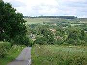
The village sits in a broad valley of the Lincolnshire Wolds, between two streams, that rise in the surrounding hills. These eventually become what is known to the south as Hagnaby Beck. The village is at about 25m above sea level.[5]
To the North West the land rises to the 105m on Horncastle Hill, where the parish boundary falls at the highest point in the parish, if not quite the summit of the hill. To the north west the road called Spilsby Hill climbs to a separate high point at Highfield Farm. Between these two the narrow Sow Dale leads down to the village, where another Knoll called Knoll Hill stands. Sow Dale is the largest of the narrow valleys that cut through the Spilsby Sandstone ridge that forms the high plateau above the village. The traditional grazed landscape is now represented by two nature reserves only.[10] Only the Lower one is in the parish, the upper one is adjacent to the boundary.[5]
Another hill to the south east more high ground forms Keal Hill and Hall Hill where the parish boundary is drawn. So there is another small dale leading down into the village from the east. To the southwest another hill known as Kirkby Hill is topped with a former windmill that sits just within the parish boundary.[11][5]
The high portions of the parish are composed of the Spilsby Sandstone,[12] which overlays here the deeper Kimmeridge and Ampthill mudstones. Eroded by the streams in the Dales, the Sandstones are removed, exposing in part the mudstone layer, although in general these are covered in the village and the river valley to the south-west by the Quaternary post-glacial sands and gravels of the Bain Valley formation.[13][14]
The parish boundary is complex, but can be summarised as surrounding the village, which is broadly central, and enclosing the rising ground in all directions. It generally does not include the plateau above the village. No major roads cross the parish, but the village is joined by minor roads to many surrounding settlements. There are, and were, no railway connections.[5]
Community
Events at the castle site are overseen by Heritage Lincolnshire, and locally by The friends of Bolingbroke Castle, who also arrange other local charitable functions.[15]
The Parish Council own and maintain the King George V Playing Field and the Ramsden Village Hall, the latter named for John & Eleanor Ramsden who bequeathed the land used for both to the village in 1937.[1][16]
The mobile library visits for an hour a month.[17]
The ecclesiastical parish of Old Bolingbroke is part of the Spilsby, Marden Hill, Stickney & Partney Group Parishes of the Deanery of Bolingbroke. The parish church is dedicated to Saint Peter and Saint Paul.[18][19]
The village's Methodist Chapel in Chapel Lane was built in 1845.[20] It is part of the Mid Lincolnshire Circuit. The congregation chose to become an Eco-congregation in July 2007.[1][21]
-

Church of Saints Peter & Paul
-

Methodist chapel, built in 1845
-

Street party in West Keal Road, 29 April 2011, organised to celebrate the marriage of Prince William and Catherine Middleton
References
- 1 2 3 "Bolingbroke parish council". Lincolnshire county council. Retrieved 2 October 2013.
- ↑ "Oasby - Ryland". Parishes: Administrative Information. Lincolnshire county council. p. 2. Retrieved 2 October 2013.
- ↑ "Statistics about Bolingbroke, East Lindsey" (PDF). Lincolnshire county council. Retrieved 3 October 2013.
- ↑ "Parish population 2011". Retrieved 19 June 2015.
- 1 2 3 4 5 Boston: Tattershall, Billinghay & Heckington (Map) (A1 ed.). 1:25000. Explorer. Ordnance Survey. § 261. ISBN 9780319238172.
- ↑ "Bolingbroke". Open Domesday. Retrieved 4 October 2013.
- ↑ "Stori of Bolingbroke". Open Domesday. Retrieved 4 October 2013.
- ↑ Historic England. "Bolingbroke castle (354204)". PastScape. Retrieved 2 October 2013.
- ↑ Historic England. "Battle of Winceby (354204)". PastScape. Retrieved 2 October 2013.
- ↑ "Sow dale". LWT Nature Reserves. Wildlife trust for Lincolnshire. Retrieved 3 October 2013.
- ↑ Simmons, H E S. "Kirkby Hill Windmill, Bolingbroke, Lincolnshire". Europeana. Retrieved 2013-10-04.
- ↑ "Upper Spilsby Sandstone". The BGS Lexicon of Named Rock Units. British Geological Survey. Retrieved 3 October 2013.
- ↑ "Bain Valley formation.". The BGS Lexicon of Named Rock Units. British Geological Survey. Retrieved 3 October 2013.
- ↑ "Geology of Britain viewer". British geological Survey. Retrieved 13 September 2013.zoom to the location, and click to identify the strata
- ↑ "Friends of Bolingbroke Castle". Lincolnshire county council. Retrieved 2 October 2013.
- ↑ "Old Bolingbroke The Ramsden Village Hall". Lincolmshire county council. Retrieved 2 October 2013.
- ↑ "Tuesdays route 1". Mobile library service. Lincolnshire county council. Retrieved 2 October 2013.
- ↑ "Spilsby, Marden Hill, Stickney & Partney Group Parishes". Spilsby Area Parishes. 2013. Retrieved 2 October 2013.
- ↑ "Ecclesiastical parish details". Diocese of Lincoln. Retrieved 2 October 2013.
- ↑ Stell, Christopher (2002). Nonconformist Chapels and Meeting-houses in Eastern England. English Heritage. p. 198. ISBN 978-1873592502.
- ↑ "Mid Lincolnshire Methoist Circuit". The Methodist Church. 2009. Retrieved 3 October 2013.
Further reading
- Pevsner, Nikolaus; Harris, John (1964). Lincolnshire. The Buildings of England. Harmondsworth: Penguin Books. pp. 330–331.
- Frampton, David; Garnham, Peter. The Battle of Winceby 1643.
- "Battle of Winceby 11th October 1643". Battlefield resource centre. The Battlefield Trust. Retrieved 3 October 2013.
External links
 Media related to Bolingbroke, Lincolnshire at Wikimedia Commons
- "all 26 historical records for the parish". Pastscape. English Heritage.
- "History of Bolingbroke, in East Lindsey and Lincolnshire". A Vision of Britain through Time. GB Historical GIS / University of Portsmouth. Retrieved 3 October 2013.
- Canfield, C. P. (August 2009). "OLD BOLINGBROKE, St. Peter & St. Paul (TF 349 652)". English Church Architecture - Lincolnshire. Retrieved 3 October 2013.
England Portal | |
| Unitary authorities | |
| Boroughs or districts | |
| Major settlements |
|
| Topics | |