Humber, Mississippi
| Humber, Mississippi | |
|---|---|
| Unincorporated community | |
 Humber  Humber | |
| Coordinates: 34°16′50″N 90°42′12″W / 34.28056°N 90.70333°WCoordinates: 34°16′50″N 90°42′12″W / 34.28056°N 90.70333°W | |
| Country | United States |
| State | Mississippi |
| County | Coahoma |
| Elevation | 164 ft (50 m) |
| Time zone | Central (CST) (UTC-6) |
| • Summer (DST) | CDT (UTC-5) |
| GNIS feature ID | 689278[1] |
Humber is an unincorporated community in Coahoma County, Mississippi, United States.
Humber had a post office in the early 1900s, and was located directly on the Mississippi River.[2]
The Humber Archeological Site is located west of Humber on Island No. 63 in the Mississippi River.[3]
The Mississippi Levee now lies between the town and the river.
References
- ↑ "Humber, Mississippi". Geographic Names Information System. United States Geological Survey.
- ↑ Rowland, Dunbar (1907). Mississippi: Comprising Sketches of Counties, Towns, Events, Institutions, and Persons, Arranged in Cyclopedic Form. 1. Southern Historical Publishing Association. p. 666.
- ↑ Brown, Ian W. (2008). Rafferty, Janet; Peacock, Evan, eds. Cultural Contact Along the I-69 Corridor: Protohistoric and Historic Use of the Northern Yazoo Basin, Mississippi. Time's River: Archaeological Syntheses from the Lower Mississippi Valley. University of Alabama Press. p. 365.
Municipalities and communities of Coahoma County, Mississippi, United States | ||
|---|---|---|
| City | 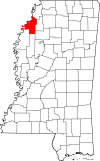 | |
| Towns | ||
| CDP | ||
| Other unincorporated communities | ||
| Ghost towns | ||
| Footnotes | ‡This populated place also has portions in an adjacent county or counties | |
This article is issued from Wikipedia - version of the 7/30/2016. The text is available under the Creative Commons Attribution/Share Alike but additional terms may apply for the media files.