Hollandse IJssel
| Hollandse IJssel | |
| River | |
 | |
| Country | Netherlands |
|---|---|
| States | South Holland, Utrecht |
| Source | Merwede Canal |
| - location | Nieuwegein, Utrecht |
| - coordinates | NL 52°01′57″N 5°05′27″E / 52.03250°N 5.09083°E |
| Mouth | Nieuwe Maas |
| - location | Rotterdam, South Holland |
| - coordinates | NL 51°54′29″N 4°33′40″E / 51.90806°N 4.56111°ECoordinates: NL 51°54′29″N 4°33′40″E / 51.90806°N 4.56111°E |
| Length | 46 km (29 mi) |
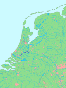 Location of Hollandse IJssel in dark blue. | |
The Hollandse (or Hollandsche) IJssel ("Holland IJssel", as opposed to the 'regular' or Gelderland IJssel) is a branch of the Rhine delta that flows westward from Nieuwegein on river Lek through IJsselstein, Gouda and Capelle aan den IJssel to Krimpen aan den IJssel, where it ends in the Nieuwe Maas. Another branch called Enge IJssel ("Narrow IJssel") flows southwest from Nieuwegein. The name IJssel is thought to derive from the Germanic i sala, meaning "dark water". Originally, the Hollandse IJssel forked off from river Lek at Nieuwegein, but the connection was cut off with the Hollandse IJssel nowadays only draining the surrounding pastures.
The first part of the Delta Works sea protection constructions was built at the mouth of the Hollandse IJssel in 1957.
 Satellite image of the Rhine branches around the city of Utrecht showing the upper stretch of the Hollandse IJssel (f). |
 Satellite image of the northwestern part of the Rhine-Meuse delta showing the lower stretch of river Hollandse IJssel (m). |
See also
|