Hagerstown, Indiana
| Hagerstown, Indiana | |
|---|---|
| Town | |
|
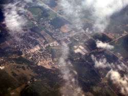
Hagerstown from the air, looking northeast. | |
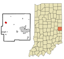 Location in the state of Indiana | |
| Coordinates: 39°54′41″N 85°9′38″W / 39.91139°N 85.16056°WCoordinates: 39°54′41″N 85°9′38″W / 39.91139°N 85.16056°W | |
| Country | United States |
| State | Indiana |
| County | Wayne |
| Township | Jefferson |
| Area[1] | |
| • Total | 1.34 sq mi (3.47 km2) |
| • Land | 1.34 sq mi (3.47 km2) |
| • Water | 0 sq mi (0 km2) |
| Elevation[2] | 1,040 ft (317 m) |
| Population (2010)[3] | |
| • Total | 1,787 |
| • Estimate (2012[4]) | 1,769 |
| • Density | 1,333.6/sq mi (514.9/km2) |
| Time zone | EST (UTC-5) |
| • Summer (DST) | EDT (UTC-4) |
| ZIP code | 47346 |
| Area code(s) | 765 |
| FIPS code | 18-30402[5] |
| GNIS feature ID | 452048 |
| Website | http://www.hagerstown.in.gov/ |
Hagerstown is a town in Jefferson Township, Wayne County, Indiana, United States.[6] As of the 2010 census, the population was 1,787.
Geography
Hagerstown is located at 39°54′41″N 85°9′38″W / 39.91139°N 85.16056°W (39.911307, -85.160564).[7] The town lies 61 miles (99 kilometers) ENE of Indianapolis, Indiana, 17 miles (27 kilometers) NW of Richmond, Indiana, and 63 miles (102 kilometers) WNW of Dayton, Ohio in the Midwestern region of the United States.
Terrain surrounding Hagerstown consists of flat land at an elevation of roughly 1000 feet above sea level that is used primarily for agriculture.
According to the 2010 census, Hagerstown has a total area of 1.34 square miles (3.47 km2), all land.[1]
Demographics
| Historical population | |||
|---|---|---|---|
| Census | Pop. | %± | |
| 1850 | 606 | — | |
| 1860 | 638 | 5.3% | |
| 1870 | 830 | 30.1% | |
| 1880 | 892 | 7.5% | |
| 1890 | 873 | −2.1% | |
| 1900 | 862 | −1.3% | |
| 1910 | 936 | 8.6% | |
| 1920 | 1,238 | 32.3% | |
| 1930 | 1,262 | 1.9% | |
| 1940 | 1,638 | 29.8% | |
| 1950 | 1,694 | 3.4% | |
| 1960 | 1,730 | 2.1% | |
| 1970 | 2,059 | 19.0% | |
| 1980 | 1,950 | −5.3% | |
| 1990 | 1,835 | −5.9% | |
| 2000 | 1,768 | −3.7% | |
| 2010 | 1,787 | 1.1% | |
| Est. 2015 | 1,728 | [8] | −3.3% |
2010 census
As of the census[3] of 2010, there were 1,787 people, 751 households, and 467 families residing in the town. The population density was 1,333.6 inhabitants per square mile (514.9/km2). There were 826 housing units at an average density of 616.4 per square mile (238.0/km2). The racial makeup of the town was 97.7% White, 0.6% African American, 0.2% Native American, 0.3% Asian, and 1.2% from two or more races. Hispanic or Latino of any race were 0.8% of the population.
There were 751 households of which 31.4% had children under the age of 18 living with them, 47.1% were married couples living together, 10.7% had a female householder with no husband present, 4.4% had a male householder with no wife present, and 37.8% were non-families. 33.0% of all households were made up of individuals and 16.5% had someone living alone who was 65 years of age or older. The average household size was 2.38 and the average family size was 3.02.
The median age in the town was 37.9 years. 25.6% of residents were under the age of 18; 8.3% were between the ages of 18 and 24; 25.1% were from 25 to 44; 23.1% were from 45 to 64; and 17.9% were 65 years of age or older. The gender makeup of the town was 48.4% male and 51.6% female.
2000 census
As of the census[5] of 2000, there were 1,768 people, 787 households, and 498 families residing in the town. The population density was 1,276.0 people per square mile (491.1/km²). There were 832 housing units at an average density of 600.5 per square mile (231.1/km²). The racial makeup of the town was 99.26% White, 0.28% African American, 0.06% Native American, 0.11% Asian, 0.06% from other races, and 0.23% from two or more races. Hispanic or Latino of any race were 0.34% of the population.
There were 787 households out of which 28.8% had children under the age of 18 living with them, 52.5% were married couples living together, 8.4% had a female householder with no husband present, and 36.6% were non-families. 34.6% of all households were made up of individuals living alone and 16.6% had someone living alone who was 65 years of age or older. The average household size was 2.25 and the average family size was 2.86.
The population has 24.0% under the age of 18, 7.0% from 18 to 24, 28.1% from 25 to 44, 23.9% from 45 to 64, and 17.1% who were 65 years of age or older. The median age was 39 years. For every 100 females there were 85.5 males. For every 100 females age 18 and over, there were 82.1 males.
The median income for a household in the town was $36,691, and the median income for a family was $48,864. Males had a median income of $35,536 versus $25,913 for females. The per capita income for the town was $20,901. About 0.8% of families and 1.8% of the population were below the poverty line, including none of those under age 18 and 0.9% of those age 65 or over.
History
Hagerstown was laid out and platted in 1832.[10] It was named after the city of Hagerstown, Maryland.[11]
The Hagerstown post office has been in operation since 1836.[12]
The Whitewater Canal, which was built in the mid-19th century and extends to Lawrenceburg, Indiana, has its northern terminus in Hagerstown.[13] This section was funded by the Hagerstown Canal Company.
The Hagerstown I.O.O.F. Hall and John and Caroline Stonebraker House are listed on the National Register of Historic Places.[14][15]
Sites of interest
- Hagerstown - Jefferson Township Library
- Willie and Red's Smorgasboard (formerly Wellivers)
- Hartley Hills Country Club
- Abbott's Candy - Candy factory
- Nettle Creek Valley Museum
- Hagerstown Park - Playground, hiking trails, sport fields, picnic areas
- Hagerstown Nature Preserve
- Near Hagerstown and Millville, Indiana is the Wilbur Wright Birthplace and Museum.
- Tedco Toys, an education and science toy manufacturer. The company is notable for its gyroscopes and is the world's largest maker of the toy.
- The American Communications Network/Brian Bex Report (publishing and communications company) operates in Hagerstown.
Education
Hagerstown Elementary and Hagerstown Jr./Sr. High School provide education for Hagerstown and smaller communities nearby. Hagerstown Jr./Sr. High School occupies a large campus which includes an outdoor laboratory and sporting facilities.
Notable people
- Charles H. Black, automobile pioneer
- Omer Madison Kem, American politician.
- Ralph Teetor, inventor of cruise control and president of the Perfect Circle Corporation.
Media
Radio
WBSH (91.1 FM): Repeater for National Public Radio affiliated station owned by Ball State University.
Transportation
Hagerstown is situated on State Road 38, which passes through the town and intersects with State Road 1. Directly south of the town is Interstate 70, enabling travel and commuting to larger cities such as Indianapolis or Richmond.
By air, Hagerstown is served by the Hagerstown Airport. This is a public-use airport and utilizes a grass runway. The nearest commercial airport is Dayton International Airport in Dayton, Ohio.
The nearest rail link is the Amtrak station located in Connersville, Indiana.
Municipal Partnerships
-
 Hagerstown, Maryland, U.S. (official October,2013)
References
- 1 2 "G001 - Geographic Identifiers - 2010 Census Summary File 1". United States Census Bureau. Retrieved 2015-07-16.
- ↑ "US Board on Geographic Names". United States Geological Survey. October 25, 2007. Retrieved 2016-07-07.
- 1 2 "American FactFinder". United States Census Bureau. Retrieved 2012-12-11.
- ↑ "Population Estimates". United States Census Bureau. Retrieved 2013-06-25.
- 1 2 "American FactFinder". United States Census Bureau. Retrieved 2008-01-31.
- ↑ "Hagerstown, Indiana". Geographic Names Information System. United States Geological Survey. Retrieved 2016-07-07.
- ↑ "US Gazetteer files: 2010, 2000, and 1990". United States Census Bureau. 2011-02-12. Retrieved 2011-04-23.
- ↑ "Annual Estimates of the Resident Population for Incorporated Places: April 1, 2010 to July 1, 2015". Retrieved July 2, 2016.
- ↑ "Census of Population and Housing". Census.gov. Retrieved June 4, 2015.
- ↑ Young, Andrew White (1872). History of Wayne County, Indiana, from Its First Settlement to the Present Time. R. Clarke & Company. p. 280.
- ↑ "Profile for Hagerstown, IN". ePodunk. Retrieved July 7, 2016.
- ↑ "Wayne County". Jim Forte Postal History. Retrieved July 7, 2016.
- ↑ History of Wayne County, Indiana: Together with Sketches of Its Cities, Villages and Towns, Volume 2. Inter-State Publishing Company. 1884. p. 616.
- ↑ National Park Service (2010-07-09). "National Register Information System". National Register of Historic Places. National Park Service.
- ↑ "National Register of Historic Places Listings". Weekly List of Actions Taken on Properties: 12/15/14 through 12/19/14. National Park Service. 2014-12-24.
External links
- Town of Hagerstown, Indiana website
- Hagerstown on waynet.org
- Hagerstown City Data w/ Photos
- Story of Perfect Circle
- Airplane Museums in Indiana
- Current Hagerstown Weather
- Whitewater Canal
Municipalities and communities of Wayne County, Indiana, United States | ||
|---|---|---|
| City | ||
| Towns | ||
| Townships | ||
| Unincorporated communities | ||