Guzara
| Guzara | |
|---|---|
 Guzara Location in Afghanistan | |
| Coordinates: 34°13′0″N 62°13′18″E / 34.21667°N 62.22167°ECoordinates: 34°13′0″N 62°13′18″E / 34.21667°N 62.22167°E | |
| Country |
|
| Province | Herat Province |
| District | Guzara District |
| Time zone | UTC+4:30 |
Guzara (Gozareh) is a village and the center of Guzara District in Herat Province, Afghanistan on 34°13′00″N 62°13′00″E / 34.2167°N 62.2167°E at 992 m altitude. The Herat Airfield is very close to the village to the east.
| Capital | 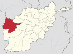 | |
|---|---|---|
| Districts | ||
| Cities | ||
| Landmarks |
| |
This article is issued from Wikipedia - version of the 2/26/2015. The text is available under the Creative Commons Attribution/Share Alike but additional terms may apply for the media files.