Shindand District

Shindand (Pashto: شين ډنډ; formerly known as Sabzwar (سبزوار) [1]), also called Zerkoh District, is one of the 16 districts of Herat Province, in western Afghanistan, and is situated in the southern part of that province. It borders Adraskan District to the north, Ghor Province to the east and Farah Province to the south and west. The population was 173,800 (as of 2012).[2][3] The district center is the town of Shindand, which boasts a very active market area. Shindand Air Base is located near the town. The main Herat-Kandahar road passes through the district. The Zerekoh Valley is in the district.
History
Its ancient name was Esfezar [4] as still an Iranian small city, more a village, close to the border of Afghanistan on the Iranian side. Notable historical sites in Shindand include Qala-Dokhtar and Qala Rustam-Zal.
Divisions
Shindand District is divided into five bigger districts, namely: Zawol, Zerkoh, Poshteh-Koh, Kooh-Zoor and Qasaba. Shindand District is one of the most diverse and wide districts in Afghanistan, representing thirty different Afghan tribes which include both Tajik and Pashtun groups and sub-groups. Ismail Khan, the current Minister of Energy and Water is still ruling in this district and have major support, specially among his Tajik fellows. Ismail Khan hails from Shindand province.
Demography
In terms of tribal and ethnic groups, Shindand is one of the most diverse districts in Herat Province. Around 60 percent of the population is Pashtun and around 40% percent consists of Tajik Aimaq Hazara (Timuris and other sub-tribes) and some Balochi people. However, sixty percent of Tajiks live within the city of Shindand, which includes Qasaba and surrounding districts.
Climate
Shindand enjoys lots of sunshine and winds all year long. Though the winds pick up during the months of May through September, called Badayeh-Sado-Bist Roozeh (120 Day Winds). The rainy season is from November/December to March/April, though the rains are scattered.
Notes
- ↑ Dupree, Nancy Hatch (1971) An Historical Guide To Afghanistan Chapter 15, Afghan Tourist Organization, Kabul OCLC 241390
- ↑ http://www.mrrd-nabdp.org/attachments/article/237/Herat%20Provincial%20Profile.pdf
- ↑ STABILITY IN KEY AREAS (SIKA) – WEST - SHINDAND DISTRICT PROFILE, p. 1, http://pdf.usaid.gov/pdf_docs/PA00JG5G.pdf
- ↑ Journal of the Asiatic Society of Bengal, Band 22,Ausgaben 1-7, p. 157-159
References
External links
- photos of Shindand District Robert Lankenau, 2005-03
| Capital | 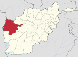 | |
|---|---|---|
| Districts | ||
| Cities | ||
| Landmarks |
| |
Coordinates: 33°18′13″N 62°08′24″E / 33.3036°N 62.1400°E