Ghurian District
| Ghurian غوریان | |
|---|---|
| District | |
 Ghurian Location within Afghanistan | |
| Coordinates: 34°20′38″N 61°28′47″E / 34.3438°N 61.4798°E | |
| Country |
|
| Province | Herat Province |
| Area | |
| • Total | 7,385 km2 (2,851 sq mi) |
| Population (2012)[1] | |
| • Total | 85,900 |
The Ghurian District (Ghoryan District)[2] is an Afghan administrative district (Wuleswali) in far western Afghanistan in western Herat Province. The district is bordered by Iran to the west and northwest. It is then bordered by other districts of Herat, Kohsan District in the north, Zendeh Jan District to the east, and Adraskan District to the south. The Hari River flows through the northeastern end of the district. The border with Iranian is marshy. The population is 85,900 (est. 2012)[1] and the district center is the city of Ghurian.
Economy
After the fall in 1992 of the Najibullah government with the final withdrawal of Soviet military aid, Iran began repatriating Afghan refugees. Many refugees who returned to Ghurian after working as migrants in Iran's saffron industry came with corms and the skills to grow and produce saffron. The United Nations, the World Bank, and later governments supported growing saffron as a crop that is economically competitive with opium poppies and, importantly for the arid west, also requires less water than wheat growing. Ghurian farmers led in bringing a small but viable saffron trade to Herat Province.[3]
External links
- Map of Settlements IMMAP, August 2014
References
- 1 2 "Settled Population of Herat Province" (PDF). Central Statistics Organization. Retrieved 6 January 2016.
- ↑ "Summary of District Development Plan" (PDF). Ghoryan District Development Assembly. Retrieved 6 January 2016.
- ↑ World Bank, Saffron as an alternative to opium poppies
| Capital | 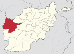 | |
|---|---|---|
| Districts | ||
| Cities | ||
| Landmarks |
| |