Grayling, Michigan
| Grayling, Michigan | |
|---|---|
| City | |
 Location of Grayling, Michigan | |
| Coordinates: 44°39′47″N 84°42′39″W / 44.66306°N 84.71083°W | |
| Country | United States |
| State | Michigan |
| County | Crawford |
| Area[1] | |
| • Total | 2.04 sq mi (5.28 km2) |
| • Land | 2.01 sq mi (5.21 km2) |
| • Water | 0.03 sq mi (0.08 km2) |
| Elevation | 1,138 ft (347 m) |
| Population (2010)[2] | |
| • Total | 1,884 |
| • Estimate (2012[3]) | 1,874 |
| • Density | 937.3/sq mi (361.9/km2) |
| Time zone | Eastern (EST) (UTC-5) |
| • Summer (DST) | EDT (UTC-4) |
| ZIP codes | 49738-49739 |
| Area code(s) | 989 |
| FIPS code | 26-34640[4] |
| GNIS feature ID | 0627264[5] |
| Website | The City of Grayling, Michigan |
Grayling /ˈɡreɪlɪŋ/ is a city in the U.S. state of Michigan and the county seat of Crawford County.[6] The population was 1,884 at the 2010 census.
Grayling is surrounded by Grayling Township. It is located in the middle of Northern Michigan. The highways (![]() I-75,
I-75, ![]() US 127,
US 127,![]() M-72, and
M-72, and ![]() M-93) make it the natural 'gateway' to much of "up north," as it is known to locals and many visitors. Grayling is perhaps most famous for hosting the Au Sable River Canoe Marathon in July of every year since 1947. The city is named after the Grayling species of fish once abundant in the Au Sable River, although the species has long since been extinct in the area [7]
M-93) make it the natural 'gateway' to much of "up north," as it is known to locals and many visitors. Grayling is perhaps most famous for hosting the Au Sable River Canoe Marathon in July of every year since 1947. The city is named after the Grayling species of fish once abundant in the Au Sable River, although the species has long since been extinct in the area [7]
History
Michael Sloat Hartwick was Grayling's first settler. On the west side of the railroad tracks, he built a log hotel. The railroad platted out 40 acres (where Grayling now stands), naming it "Crawford." Fish swimming in the river were identified as grayling fish, and it is said that the residents preferred the name "Grayling" to the name "Crawford," and renamed the area after the fish.[8]
Grayling's access to two major rivers (Au Sable River and Manistee River), and the presence of the vast forest around it, made it important in the lumber era. Logs were floated down the rivers to the lakes.[9]
Grayling had other names through the years. It was called "AuSable", "Forest", "Crawford Station", and during the lumbering era "Milltown".[10]
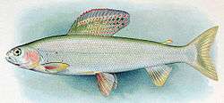
The Arctic grayling that had inhabited much of Northern Michigan[11] was eventually wiped out. The logging practice of using river beds to move logs in the springtime destroyed the breeding grounds for these fish. [12] Before they could recover, non-native sport fish such as brook trout were introduced in the 1890s[13] and competed with the grayling for food.
The Grayling Fish Hatchery was founded in 1914 by timber baron Rasmus Hanson (1846–1927).[14] He hoped to restore the grayling to the Au Sable River system; ironically its disappearance was caused, at least in part, by the massive habitat destruction caused by logging, which was the source of Mr. Hanson's and other lumber barons' immense wealth. Other famous contributors to the initial costs of the Hatchery included Henry Ford, Edsel Ford, and Thomas Edison.[14] The grayling became extinct in Michigan. Nevertheless, the Hatchery continued to play an important role in natural resource conservation. In 1926 it was sold to the State of Michigan. It continued to be operated as a fish hatchery and tourist attraction until the mid-1960s. In 1995 the State of Michigan sold the property to Crawford County. It is being operated by a privately owned fish farm, although continues to be open to the public during the summer.[15]
An important person in the history of Grayling is Rasmus Hanson. Hanson was born in 1846 in Denmark and immigrated to the United States in 1867 at age 16. This is when he began work in the lumber field. Two years later he, along with E. N. Salling and Nelson Michelson, organized the first Salling-Hanson Company. After nearly 50 years of service, the Salling Hanson Company had shut down its operation in January 1927. He was a successful entrepreneur and created many businesses in Northern Michigan. Along with being one of three lumber barons of Northern Michigan, Hanson owned the Michigan Sugar Company and the Bay City Sugar Company. In 1916, he donated 13,826 acres of cut-over land in Crawford County to the state of Michigan for use as a forest game preserve and military reservation. This land became the first state-owned game preserve. The area south of Lake Margrethe (named in honor of Hanson’s wife, Margrethe) continues to be used as a National Guard base that serves Michigan, Ohio and Indiana guards.[16] Since 1947 Grayling has been the starting point of the Au Sable River Canoe Marathon, which is held every year on the last weekend of July.[17] This is the longest non-stop canoe race in North America.
Geography
- The middle branch of the Au Sable River passes through the city.
- According to the United States Census Bureau, the city has a total area of 2.04 square miles (5.28 km2), of which 2.01 square miles (5.21 km2) is land and 0.03 square miles (0.08 km2) is water.[1]
- Nearby Camp Grayling (donated by Rasmus Hanson) is the nation's largest National Guard training site and the largest military installation east of the Mississippi River. 147,000 acres (590 km2) are used for year-round training conducted by the U.S. National Guard, as well as active and reserve components of the Army, Air Force, Marine Corps and Navy.
- The city is near Lake Margrethe.
- Hartwick Pines State Park is just 7 miles (11 km) north and northeast of Grayling.
- The Huron portion of the Huron-Manistee National Forests is about the same distance due east.
- If one travels to the east out of the city along the Au Sable River, one encounters North Down River Road, which runs parallel to it. It is a designated National Scenic Byway for the 23 miles (37 km) that go into Oscoda. The Lumberman's Monument is located along the byway.
- There is an oilfield about 4 miles (6.4 km) south of M-93 on Military Road.
Geographic features
- Au Sable River
- Manistee River
- Lake Margrethe
- Much of the area sits on the "Grayling outwash plain", a unique habitat named for the city.[18]
- There is a nearby oilfield.
Climate
This climatic region has large seasonal temperature differences, with warm to hot (and often humid) summers and cold (sometimes severely cold) winters. According to the Köppen Climate Classification system, Grayling has a humid continental climate, abbreviated "Dfb" on climate maps.[19]
Demographics
| Historical population | |||
|---|---|---|---|
| Census | Pop. | %± | |
| 1910 | 1,775 | — | |
| 1920 | 2,450 | 38.0% | |
| 1930 | 1,973 | −19.5% | |
| 1940 | 2,124 | 7.7% | |
| 1950 | 2,066 | −2.7% | |
| 1960 | 2,015 | −2.5% | |
| 1970 | 2,143 | 6.4% | |
| 1980 | 1,792 | −16.4% | |
| 1990 | 1,944 | 8.5% | |
| 2000 | 1,952 | 0.4% | |
| 2010 | 1,884 | −3.5% | |
| Est. 2015 | 1,844 | [20] | −2.1% |
2010 census
As of the census[2] of 2010, there were 1,884 people, 764 households, and 419 families residing in the city. The population density was 937.3 inhabitants per square mile (361.9/km2). There were 890 housing units at an average density of 442.8 per square mile (171.0/km2). The racial makeup of the city was 97.2% White, 0.7% African American, 0.5% Native American, 0.5% Asian, 0.1% Pacific Islander, 0.1% from other races, and 0.9% from two or more races. Hispanic or Latino of any race were 1.7% of the population.
There were 764 households of which 29.8% had children under the age of 18 living with them, 32.9% were married couples living together, 16.9% had a female householder with no husband present, 5.1% had a male householder with no wife present, and 45.2% were non-families. 37.7% of all households were made up of individuals and 18.4% had someone living alone who was 65 years of age or older. The average household size was 2.27 and the average family size was 3.00.
The median age in the city was 38.6 years. 23.8% of residents were under the age of 18; 9.5% were between the ages of 18 and 24; 23.9% were from 25 to 44; 22.1% were from 45 to 64; and 20.7% were 65 years of age or older. The gender makeup of the city was 46.7% male and 53.3% female.
2000 census
As of the census[4] of 2000, there were 1,952 people, 828 households, and 481 families residing in the city. The population density was 972.1 per square mile (375.0/km2). There were 895 housing units at an average density of 445.7 per square mile (171.9/km2). The racial makeup of the city was 96.88% White, 0.51% African American, 0.87% Native American, 0.77% Asian, 0.15% from other races, and 0.82% from two or more races. Hispanic or Latino of any race were 1.54% of the population.
There were 828 households out of which 30.7% had children under the age of 18 living with them, 37.4% were married couples living together, 16.3% had a female householder with no husband present, and 41.8% were non-families. 38.3% of all households were made up of individuals and 20.3% had someone living alone who was 65 years of age or older. The average household size was 2.24 and the average family size was 2.94.
In the city the population was spread out with 26.1% under the age of 18, 7.7% from 18 to 24, 24.5% from 25 to 44, 19.1% from 45 to 64, and 22.5% who were 65 years of age or older. The median age was 40 years. For every 100 females there were 78.4 males. For every 100 females age 18 and over, there were 70.7 males.
The median income for a household in the city was $24,250, and the median income for a family was $29,850. Males had a median income of $29,167 versus $20,060 for females. The per capita income for the city was $13,089. About 21.6% of families and 21.8% of the population were below the poverty line, including 29.5% of those under age 18 and 17.5% of those age 65 or over.
Arts and culture
Historical sites and local events
The area is proud of its history, and has preserved landmarks, which it uses for historical events, including reenactments.[22]
- Crawford County Historical Museum. Located in downtown's restored railroad depot, the museum offers a nostalgic look at the 19th and 20th centuries, particularly the lumbering era. The depot was saved from demolition by a community effort. The grounds also include a caboose, a military building dedicated to Camp Grayling and local ex-military personnel, a trapper's cabin, and an old fashioned fire station.
- Wellington Farm Park is a 60-acre (240,000 m2), non-profit living history museum It is dedicated to interpretation of farm life during the Great Depression. Many farming activities are conducted daily with vintage equipment, tools, and methods. The park has many historical buildings including a blacksmith shop, farm market, gristmill, pavilion, sawmill, and summer kitchen. A nature trail is there. Several events are hosted throughout the summer and fall, including "Dairy Days", "Tractor & Engine Show", "Punkin-Chunkin", Halloween Hayrides, and numerous weekend activities. The farm is located on Military Road West of I-75.
- Lake Margrethe is big and beautiful. It is an important attraction of Camp Grayling, and was named after the wife of Rasmus Hanson. It is a favorite fishing and recreation lake for soldiers in their off-duty hours, but also sees much use from area residents, campers and tourists, who access it from the state forest campground located at the lake's northwest corner.
- See also List of Historical Markers in Crawford County, Michigan.
There are a number of recurring events in the area. A calendar is available.[23]
- Grayling is the starting point for the Weyerhauser Au Sable River Canoe Marathon which runs 120 miles (190 km) from Grayling to Oscoda, Michigan. It is one of three marathon races that constitute canoe racing's Triple Crown. The race is always held the last full weekend in July during the town's annual AuSable River Festival.
- Hartwick Pines State Park – the location of one of the few remaining old growth eastern white pine forests – has events throughout the year.[24] Particularly notable are "cross country skiing by lantern light" on numerous dates throughout the winter.[23]
- Kirtland Center for the Performing Arts, located at the Kirtland Community College in Roscommon, Michigan hosts many visiting performers, including regular visits from The Second City traveling ensemble.[25]
Parks and recreation
- Grayling is noted as the "Canoe Capital of the World". There are three canoe liveries that operate on the Au Sable River in Grayling; Carlisle's Canoe, Penrods Resort, and Borchers Canoe & Kayak, the Manistee River is located just west of Grayling.
- Cross country skiing is an important opportunity in Grayling. It is blessed with two of the top-rated cross country venues in Michigan, namely Hartwick Pines State Park Trails and Mason Tract Pathway.[26] Forbush corners in nearby Frederic, Michigan is a world-recognized center for education and training in cross country skiing, and benefits from early and late snow due to a 'snow belt micro climate.' Accomplished amateur ski racer David Forbush designed, maintains, and grooms "one of the finest privately owned systems in the Midwest."[27]
- The grayling are gone, but the rainbow trout, brook trout and brown trout remain. Grayling is a hotbed of fly fishing and angling on the edge of some world class streams, rivers and lakes. Particularly notable are two nearby rivers which parallel each other: the Au Sable River which runs East to Lake Huron and the Manistee River which runs West to Lake Michigan. Trout abound, driven to a feeding frenzy by prolific and multiple insect hatches.[28]
- As is true in the rest of Michigan, white-tailed deer hunting is locally considered to be a 'sacrament' and the firearms deer opener (November 15) its 'holy day of obligation.' With 70% of Crawford County owned by federal and state government, and open to the public, it is a popular hunting destination.[29]
- Snow shoeing and snow mobile riding are activities that fit right into the local weather and topography.[30]
- Hanson Hills was the first down hill ski area in Michigan. It opened in 1929.[31]
- Michigan Shore to Shore Riding & Hiking Trail passes through Grayling. It runs from Empire to Oscoda, and points north and south. It is a 500-mile (800 km) interconnected system of trails.[32]
- The Kirtland's warbler has its habitat in the area.[33]
- Grayling was home to Fred Bear and Bear Archery Company.[34]
- It also is the home to the Au Sable River Canoe Marathon, the world's longest nonstop canoe race.
Military
Camp Grayling is a Michigan National Guard training facility located near the city. It is the largest National Guard training base in the United States. Through the year approximately 10,000 troops train at the base, and it is estimated that it generates $20 million in local economic activity.[35]
Government
Officials
- City Manager is Doug Baum [36]
Education
The Crawford AuSable School District is the primary school district for the county, serving the city of Grayling as well the nearby community. The district consists of one high school, one middle school, and one elementary school, which serve approximately 1600 students. In 2013 Grayling High School was ranked at 1503 on Newsweek's America's best high school rating, which rated the top 2000 public high schools in the US based on graduation rate, college acceptance rate, AP tests taken per student, average AP scores, number of students enrolled in AP courses, and average SAT/ACT scores. In 2014 the National Association of State Boards of Education named the district as the top performing rural school district in Michigan.[37][38][39]
Media
- The Crawford County Avalanche is the newspaper of record for Crawford County, and is published in Grayling, Michigan.[40]
Transportation
Major highways
Grayling is 4 miles (6.4 km) north of the confluence of two major north–south freeways: I-75 and US 127, and the junction with M-72, an east–west cross-peninsular state highway route.
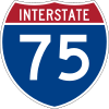 I-75 passes to the east the city and connects with the Mackinac Bridge to the north and Saginaw and Detroit to the south
 BL I-75 is a loop route running through Grayling. It follows the former route of US 27, in part.
 US 127 ends south of Grayling[41] and continues southerly toward Clare and Lansing.[42]
 M-72 passes through the city and is one of three state highway routes that runs east–west across the entire lower peninsula, from Empire on Lake Michigan to Grayling and east to Harrisville on Lake Huron.
 M-93 is an 11-mile (18 km) route connecting the main gate of Michigan Army National Guard's Camp Grayling, 4 miles (6.4 km) southwest of Grayling, with Hartwick Pines State Park, 7 miles (11 km) northeast of Grayling.
 F-32 begins at BL I-75/M-93 on the northern edge of the city and continues toward Mio.
Bus travel
- Indian Trails provides daily intercity bus service between St. Ignace and East Lansing, Michigan.[43]
References
- 1 2 "US Gazetteer files 2010". United States Census Bureau. Retrieved 2012-11-25.
- 1 2 "American FactFinder". United States Census Bureau. Retrieved 2012-11-25.
- ↑ "Population Estimates". United States Census Bureau. Retrieved 2013-06-03.
- 1 2 "American FactFinder". United States Census Bureau. Retrieved 2008-01-31.
- ↑ "US Board on Geographic Names". United States Geological Survey. 2007-10-25. Retrieved 2008-01-31.
- ↑ "Find a County". National Association of Counties. Retrieved 2011-06-07.
- ↑ "Michigan Grayling Only a Memory". Michigan Department of Natural Resources.
- ↑ "Profile for Grayling, Michigan, MI". ePodunk. Retrieved August 26, 2012.
- ↑ "Grayling Area Visitors Bureau.".
- ↑ Ibid.
- ↑ Fuller, Pam; Cannister, Matt; Neilson, Matt. "Thymallus arcticus (Pallas, 1776)". US Geological Survey. Retrieved 22 April 2016.
"Formerly in Great Lakes basin, Michigan" (with map showing Northern Michigan highlighted)
- ↑ "Michigan Grayling Only a Memory". Michigan Department of Natural Resources. Retrieved 22 April 2016.
- ↑ Borgelt, Bryon (2009). "Flies only: early sportfishing conservation on Michigan's Au Sable River". University of Toledo Theses and Dissertations. Paper 1042: ii.
"By the 1890s the grayling were all but gone due in part to over fishing, commercial lumbering and the introduction of non-native brook trout.
- 1 2 "Rasmus Hanson picture and biography".
- ↑ "Grayling Recreation Authority, fish hatchery.".
- ↑ Granlund, Bill (January 25, 2013). "A Step Back in Time: Selling Hanson Co. saw mills cut last log in 1927". petoskeynews.com. Retrieved 15 April 2013., originally published in the Otsego County Herald Times, October 6, 1927
- ↑ "AuSable River Canoe Marathon". ausablecanoemarathon.org.
- ↑ "NPWRC :: Regional Landscape". usgs.gov.
- ↑ "Grayling, Michigan Köppen Climate Classification (Weatherbase)". Weatherbase.
- ↑ "Annual Estimates of the Resident Population for Incorporated Places: April 1, 2010 to July 1, 2015". Retrieved July 2, 2016.
- ↑ "Census of Population and Housing". Census.gov. Retrieved June 4, 2015.
- ↑ Grayling Area Visitors Bureau.
- 1 2 "Chember of Commerce calendar of events".
- ↑ "Hartwick Pines State Park".
- ↑ "Kirtland Center for the Performing Arts, Kirtland College".
- ↑ "Rankings of best cross country skiing in Michigan.".
- ↑ Rankings and Discussion of Forbush corners Forbush Corners website
- ↑ "Fly fish connection".
- ↑
- ↑ "Grayling visitor center".
- ↑ "Hanson HIlls.".
- ↑ Michigan Shore to Shore Riding and Hiking Trail.
- ↑ Michigan Department of Natural Resources, Kirtland's Warbler Populations Continue to Grow.
- ↑ "Fred Bear". Retrieved August 21, 2012.
- ↑ "Camp Grayling Military Installation". Grayling Visitor's Bureau.
- ↑ "City of Grayling > Departments > City Manager". cityofgrayling.org.
- ↑ "Crawford AuSable School District" (PDF). National Association of State Boards of Education.
- ↑ "Dr. Richard Zeile visits a Top-Perfoming Rural School District in Michigan". Metavision.
- ↑ "2013 America's Best High Schools". Newsweek.
- ↑ "Crawford County Avalanche".
- ↑ "Picture of northern terminus US 127 at Grayling, Michigan".
- ↑ "Endpoints of US highways". Archived from the original on 2009-10-27.
- ↑ "EAST LANSING-PETOSKEY-ST. IGNACE" (PDF). Indian Trails. January 15, 2013. Retrieved 2013-02-27.
External links
- City of Grayling home page.
- Clarke Historical Collection, Bibliography on Crawford County
- Grayling Chamber of Commerce.
- Grayling Visitors Bureau.
Municipalities and communities of Crawford County, Michigan, United States | ||
|---|---|---|
| City | 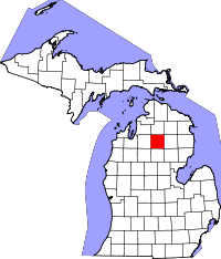 | |
| Townships | ||
| Ghost Towns | ||
Coordinates: 44°39′41″N 84°42′53″W / 44.66139°N 84.71472°W