Gerona, Tarlac
| Gerona | ||
|---|---|---|
| Municipality | ||
 | ||
| ||
 Map of Tarlac showing the location of Gerona | ||
.svg.png) Gerona Location within the Philippines | ||
| Coordinates: 15°36′N 120°36′E / 15.600°N 120.600°ECoordinates: 15°36′N 120°36′E / 15.600°N 120.600°E | ||
| Country | Philippines | |
| Region | Central Luzon (Region III) | |
| Province | Tarlac | |
| District | 2nd District | |
| Barangays | 44 | |
| Government[1] | ||
| • Mayor | Eloy C. Eclar[2] | |
| • Vice Mayor | Pacifico L. Agudo[3] | |
| Area[4] | ||
| • Total | 128.89 km2 (49.76 sq mi) | |
| Population (2010)[5] | ||
| • Total | 83,084 | |
| • Density | 640/km2 (1,700/sq mi) | |
| Time zone | PST (UTC+8) | |
| ZIP code | 2302 | |
| Dialing code | 45 | |
| Income class | 1st class | |
| Website |
www | |

Gerona (Kapampangan: Balen ning Gerona; Ilocano: Ili ti Gerona) is a first-class municipality in the province of Tarlac, Philippines. According to the 2010 census, it has a population of 83,084 people.[5]
The MacArthur Highway goes through the center of the town.
Geography
Gerona is one of the 18 towns of the province of Tarlac. It is bounded on the north by Paniqui; on the east by the Pura; on the south by Tarlac City (the provincial capital); and on the west by Santa Ignacia. The town is 72 kilometres (45 mi) from San Fernando City, the regional center; 55 kilometres (34 mi) from Angeles City; and 138 kilometres (86 mi) north of Metro Manila.
Gerona has a land area of 12,889 hectares (31,850 acres) of plain and rugged agricultural land representing 4.63% of the province total area. The Tarlac River, which originates from the eastern slopes of the Zambales Mountain, cuts across the west central areas, dividing the town into two parts.
The eastern area consists of 31 barangays with total land area of 90.50 square kilometres representing 63.9% of the total area. It is characterized as plain, low-lying agricultural land.
The second part is the Western Area consisting of 13 barangays with total area of 50.97 square kilometres representing 36.03% of the total land area. It is characterized by hilly and rugged agricultural land and is also forested.
Barangays
Gerona is politically subdivided into 44 barangays.[4]
- Abagon
- Amacalan
- Apsayan
- Ayson
- Bawa
- Buenlag
- Bularit
- Calayaan
- Carbonel
- Cardona
- Caturay
- Danzo
- Dicolor
- Don Basilio
- Luna
- Mabini
- Magaspac
- Malayep
- Matapitap
- Matayumcab
- New Salem
- Oloybuaya
- Padapada
- Parsolingan
- Pinasling (Pinasung)
- Plastado
- Poblacion 1
- Poblacion 2
- Poblacion 3
- Quezon
- Rizal
- Salapungan
- San Agustin
- San Antonio
- San Bartolome
- San Jose
- Santa Lucia
- Santiago
- Sembrano
- Singat
- Sulipa
- Tagumbao
- Tangcaran
- Villa Paz
Demographics
| Population Census of Gerona | ||
|---|---|---|
| Year | Pop. | ±% p.a. |
| 1990 | 59,486 | — |
| 1995 | 63,740 | +1.30% |
| 2000 | 72,618 | +2.83% |
| 2007 | 82,022 | +1.69% |
| 2010 | 83,084 | +0.47% |
| Source: National Statistics Office[5][6] | ||
Points of interest
- 1894 Saint Catherine of Alexandria Church of Gerona (Vicariate of St. Catherine of Alexandria, Vicar Forane: Father Alfredo Dizon, Titular: Saint Catherine of Alexandria, Feast day, November 24 Parish Priest: Father Alfredo Dizon, succeeded by Fr. Ramon Capuno Parochial Vicar: Rev. Fr. Paulo Dela Cruz - Don Federico Bartolome Street, McArthur Highway, Gerona, Tarlac 2302, Philippines under the Roman Catholic Diocese of Tarlac Roman Catholic Diocese of Tarlac led by Most Rev. Florentino F. Cinense, D.D., PhD, STL.
Images
 Town hall
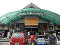 Public market
 Chuzon Supermarket
 Auditorium
 Park
Park Plaza and park
References
- ↑ "Municipalities". Quezon City, Philippines: Department of the Interior and Local Government. Retrieved 28 November 2012.
- ↑ http://www.gerona.gov.ph/index.php/government/elected-officials
- ↑ http://www.gerona.gov.ph/index.php/government/elected-officials
- 1 2 "Province: Tarlac". PSGC Interactive. Makati City, Philippines: National Statistical Coordination Board. Retrieved 28 November 2012.
- 1 2 3 "Total Population by Province, City, Municipality and Barangay: as of May 1, 2010" (PDF). 2010 Census of Population and Housing. National Statistics Office. Retrieved 28 November 2012.
- ↑ "Province of Tarlac". Municipality Population Data. LWUA Research Division. Retrieved 11 September 2013.
External links
| Wikimedia Commons has media related to Gerona, Tarlac. |
- History
- New Website
- Isdaan Floating Restaurant
- Philippine Standard Geographic Code
- Philippine Census Information
 |
Paniqui | Ramos | | |
| Santa Ignacia | |
Pura | ||
| ||||
| | ||||
| Tarlac City | Victoria |
Tarlac City (capital) | |
| Municipalities | |
| Component city | |
| Barangays | |