Gap Fire (2016)
This article is about the 2016 fire in Seiad Valley. For the 2008 fire in Santa Barbara, see Gap Fire (2008).
| Gap Fire | |
|---|---|
|
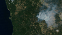
NASA MODIS satellite photo of smoke from the Gap Fire on August 30, 2016. Mount Shasta is in the lower right corner of the photograph. | |
| Location | Klamath National Forest, Seiad Valley, Siskiyou County, California |
| Coordinates | 41°51′04″N 123°07′05″W / 41.851°N 123.118°W |
| Statistics[1] | |
| Date(s) | August 27, 2016 - September 17, 2016 |
| Burned area | 33,867 acres (137 km2) |
| Map | |
 Location of fire in California | |
The Gap Fire was a 2016 wildfire that burned in Seiad Valley, California.[1] The fire burned 33,867 acres (137 km2) of land from August through September.[2]
References
- 1 2 "Gap Fire". InciWeb. Retrieved August 30, 2016.
- ↑ "Gap Fire fully contained". Times-Standard. 18 September 2016. Retrieved 22 September 2016.
This article is issued from Wikipedia - version of the 9/22/2016. The text is available under the Creative Commons Attribution/Share Alike but additional terms may apply for the media files.