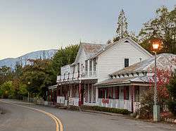
French Gulch, California
| French Gulch | |
|---|---|
| census-designated place | |
 | |
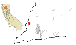 Location in Shasta County and the state of California | |
| Coordinates: 40°42′19″N 122°38′7″W / 40.70528°N 122.63528°WCoordinates: 40°42′19″N 122°38′7″W / 40.70528°N 122.63528°W | |
| Country |
|
| State |
|
| County | Shasta |
| Area[1] | |
| • Total | 12.369 sq mi (32.035 km2) |
| • Land | 12.332 sq mi (31.940 km2) |
| • Water | 0.037 sq mi (0.095 km2) 0.30% |
| Elevation | 1,355 ft (425 m) |
| Population (2010) | |
| • Total | 346 |
| • Density | 28/sq mi (11/km2) |
| Time zone | Pacific (PST) (UTC-8) |
| • Summer (DST) | PDT (UTC-7) |
| ZIP code | 96033 |
| Area code(s) | 530 |
| FIPS code | 06-26056 |
| GNIS feature ID | 0223907 |
| Reference no. | 166 |
French Gulch is a census-designated place (CDP) in Shasta County, California, United States. The population was 346 at the 2010 census, up from 254 at the 2000 census.
History
French Gulch was founded by French miners in 1849 and became one of California's major gold producing areas. The town became a major supply place when it became the terminus of the western branch of the California Trail. French Gulch was registered as a California Historical Landmark in 1935.[2]
On August 14, 2004, the entire town of French Gulch was evacuated due to a forest fire which roared out of control through much of Shasta County. The fire burned 13,005 acres and destroyed 26 residences, 1 commercial building, and 76 outbuildings. The evacuation lasted 3 days, allowing residents to return home on August 17, 2004. A total of 1,345 fire personnel helped get the blaze under the control. The cause was never determined.
Geography
French Gulch is located at 40°42′19″N 122°38′7″W / 40.70528°N 122.63528°W (40.705313, -122.635174).[3] Lying a few miles northwest of Whiskeytown Lake, the hamlet lies along Trinity Mountain Road going north from California State Route 299 with the town center about 3 miles north of 299, and about 19 highway-miles from downtown Redding.
According to the United States Census Bureau, the CDP has a total area of 12.4 square miles (32 km2), 99.70% of it land and 0.30% of it water.
Climate
This region experiences warm (but not hot) and dry summers, with no average monthly temperatures above 71.6 °F. According to the Köppen Climate Classification system, French Gulch has a warm-summer Mediterranean climate, abbreviated "Csb" on climate maps.[4]
Demographics
2010
The 2010 United States Census[5] reported that French Gulch had a population of 346. The population density was 28.0 people per square mile (10.8/km²). The racial makeup of French Gulch was 296 (85.5%) White, 3 (0.9%) African American, 15 (4.3%) Native American, 3 (0.9%) Asian, 1 (0.3%) Pacific Islander, 8 (2.3%) from other races, and 20 (5.8%) from two or more races. Hispanic or Latino of any race were 17 persons (4.9%).
The Census reported that 346 people (100% of the population) lived in households, 0 (0%) lived in non-institutionalized group quarters, and 0 (0%) were institutionalized.
There were 147 households, out of which 32 (21.8%) had children under the age of 18 living in them, 71 (48.3%) were opposite-sex married couples living together, 12 (8.2%) had a female householder with no husband present, 10 (6.8%) had a male householder with no wife present. There were 13 (8.8%) unmarried opposite-sex partnerships, and 0 (0%) same-sex married couples or partnerships. 42 households (28.6%) were made up of individuals and 16 (10.9%) had someone living alone who was 65 years of age or older. The average household size was 2.35. There were 93 families (63.3% of all households); the average family size was 2.80.
The population was spread out with 64 people (18.5%) under the age of 18, 23 people (6.6%) aged 18 to 24, 54 people (15.6%) aged 25 to 44, 141 people (40.8%) aged 45 to 64, and 64 people (18.5%) who were 65 years of age or older. The median age was 49.6 years. For every 100 females there were 104.7 males. For every 100 females age 18 and over, there were 102.9 males.
There were 166 housing units at an average density of 13.4 per square mile (5.2/km²), of which 119 (81.0%) were owner-occupied, and 28 (19.0%) were occupied by renters. The homeowner vacancy rate was 3.2%; the rental vacancy rate was 6.7%. 284 people (82.1% of the population) lived in owner-occupied housing units and 62 people (17.9%) lived in rental housing units.
2000
As of the census[6] of 2000, there were 254 people, 109 households, and 72 families residing in the CDP. The population density was 20.6 people per square mile (7.9/km²). There were 130 housing units at an average density of 10.5 per square mile (4.1/km²). The racial makeup of the CDP was 92.91% White, 3.94% Native American, 0.79% Asian, 0.39% from other races, and 1.97% from two or more races. Hispanic or Latino of any race were 2.76% of the population.
There were 109 households out of which 21.1% had children under the age of 18 living with them, 56.0% were married couples living together, 6.4% had a female householder with no husband present, and 33.9% were non-families. 24.8% of all households were made up of individuals and 11.0% had someone living alone who was 65 years of age or older. The average household size was 2.33 and the average family size was 2.71.
In the CDP the population was spread out with 20.9% under the age of 18, 2.0% from 18 to 24, 24.0% from 25 to 44, 39.0% from 45 to 64, and 14.2% who were 65 years of age or older. The median age was 47 years. For every 100 females there were 104.8 males. For every 100 females age 18 and over, there were 101.0 males.
The median income for a household in the CDP was $27,083, and the median income for a family was $31,250. Males had a median income of $41,250 versus $33,750 for females. The per capita income for the CDP was $11,943. About 21.6% of families and 24.3% of the population were below the poverty line, including 22.7% of those under the age of eighteen and 11.8% of those sixty five or over.
Politics
In the state legislature French Gulch is in the 1st Senate District, represented by Republican Ted Gaines,[7] and the 1st Assembly District, represented by Republican Brian Dahle.[8]
Federally, French Gulch is in California's 1st congressional district, represented by Republican Doug LaMalfa.[9]
References
- ↑ U.S. Census
- ↑ "French Gulch". Office of Historic Preservation, California State Parks. Retrieved 2012-10-14.
- ↑ "US Gazetteer files: 2010, 2000, and 1990". United States Census Bureau. 2011-02-12. Retrieved 2011-04-23.
- ↑ Climate Summary for French Gulch, California
- ↑ "2010 Census Interactive Population Search: CA - French Gulch CDP". U.S. Census Bureau. Retrieved July 12, 2014.
- ↑ "American FactFinder". United States Census Bureau. Retrieved 2008-01-31.
- ↑ "Senators". State of California. Retrieved March 10, 2013.
- ↑ "Members Assembly". State of California. Retrieved March 2, 2013.
- ↑ "California's 1st Congressional District - Representatives & District Map". Civic Impulse, LLC. Retrieved March 1, 2013.
Municipalities and communities of Shasta County, California, United States | ||
|---|---|---|
| Cities | 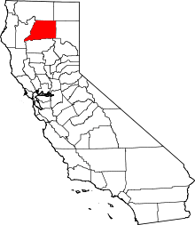 | |
| CDPs | ||
| Unincorporated communities |
| |
| Indian reservations | ||
| Ghost town |
| |