Fremington, Devon
| Fremington | |
 Sign on the village green |
|
 The Tarka Trail is a direct part-coastal path following the former railway |
|
 Fremington |
|
| Population | 4,310 2011 census[1] |
|---|---|
| District | North Devon |
| Shire county | Devon |
| Region | South West |
| Country | England |
| Sovereign state | United Kingdom |
| Post town | BARNSTAPLE |
| Postcode district | EX31 |
| Police | Devon and Cornwall |
| Fire | Devon and Somerset |
| Ambulance | South Western |
| EU Parliament | South West England |
Coordinates: 51°12′N 4°05′W / 51.20°N 4.08°W
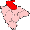
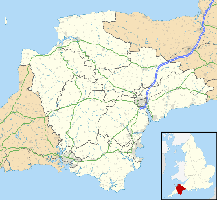
Fremington is a very large village, civil parish and former manor in North Devon, the historic centre of which is situated three miles (5 km) west of Barnstaple. There is an electoral ward with the same name. The ward mainly covers the village and the population at the 2011 census was 4,310.[2] Fremington is situated between the south bank of the tidal estuary of the River Taw and a small inlet of that river known as "Fremington Pill". Fremington Quay was formerly a port on the River Taw, half a mile north of the village centre. Fremington was formerly a borough which sent members to Parliament in the reign of King Edward III (1327–77). The parish includes the neighbouring former hamlets (greatly expanded in the 20th century) of Bickington to the east and Yelland to the west. Fremington hundred was one of the 32 historic hundreds of Devon. Fremington, Bickington and Yelland, all on the B3223 main road from Barnstaple to Instow have, according to Hoskins (1959), been spoilt by almost uninterrupted ribbon-building to provide housing for commuters to Barnstaple, but some old houses survive near the Church of St Peter, the parish church.[3] and plenty of residential property on all sides of its roads between Bideford and Barnstaple. Little Bridge House in the village is a children's hospice run by Children's Hospice South West.
Landmarks
St Peter's Church

The parish church, dedicated to St Peter, was subject to thorough Victorian restoration in 1867 to the designs of the leading architect Sir George Gilbert Scott.[4] The stone pulpit was buried during the Reformation and retains traces of the colour of the earth. St Peter's medieval tower unusually is positioned at the east end of the church, to the north of the chancel.
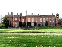
Fremington House
The large early Georgian red-brick mansion known as Fremington House, situated 50 metres east of St Peter's Church, and clearly visible from the main road, is the former manor house built by Richard II Acland (1679–1729), MP for Barnstaple 1708–13. It was re-modelled in the 19th century by his eventual heirs the Arundell-Yeo family. It is now a retirement home.
Commercial premises
Fremington has two public houses, The Fox and the New Inn, situated almost next door to each other.
Clay works
Fremington is famous for "Fishley Pottery", made by the family of that name in the Combrew area, examples of which are in the collection of the Museum of Barnstaple and North Devon. Excellent, stone-free clay pits (now mainly worked out) exist in the eastern half of the parish and were also owned by Brannam's Pottery and used for their "Barum Ware". The clay may have formed in varve lakes, near an ice deposit which lay over Fremington during the Last Glacial Maximum or previous glaciations such as the Anglian (MIS12) or the Wolstonian glaciation (MIS6)[5] Unusually, glacial deposits are found here in the county of Devon. Two patches of boulder clay lie over the centre of the parish's bedrock. The next nearest boulder clay deposits are in the Gower Peninsula, South Wales, approximately 45 miles (72 km) due north of Fremington across the Bristol Channel. The nearest deposit of boulder clay in England is in the central Cotswolds, 6 miles (10 km) due east of Bourton-on-the-Water and approximately 140 miles (225 km) north-east of Fremington. The existence of the boulder clay is puzzling as the southernmost limit of the Devensian glaciation is believed to have been located over South Wales. There are few other signs of glaciation in North Devon to support an extension to a more southerly limit. It has been suggested that the surface covering was in some way attached to an ice-mass that drifted across the Bristol Channel and deposited the till over Fremington. However this does not fully explain the presence of the nearly co-located varve clay beds.
Fremington Quay

Fremington Quay was once significant in the import and export of many goods. It had railway sidings, cranes, and other apparatus used for the export of ball clay and import of coal. Between the early to mid-twentieth century it was the busiest port (based on tonnage) between Bristol and Land's End. An abattoir was formerly located here. The quay has been redeveloped as an amenity facility with restaurant and provides wide views over the River Taw estuary. It has been a Conservation Area since 1996.
Demography
The population of Fremington, according to the census of 1801, was 875. This number increased gradually in the forty years to 1841, to 1,326 however the rate of increase slowed during the next 10 years and coinciding with the arrival of the railway fell from 1,351 in 1851 to 1,194 in 1901 and slightly lower in 1931. Population growth resumed after World War II and saw more than a doubling between 1961 and 2011, to 4,310 people. Data for 1801–1961 is available at Britain Through Time.[6] The 2001 and 2011 Censuses give detailed information about the village.
| Year | 1801 | 1811 | 1821 | 1831 | 1841 | 1851 | 1881 | 1891 | 1901 |
|---|---|---|---|---|---|---|---|---|---|
| Population | 875 | 941 | 1,099 | 1,180 | 1,326 | 1,350 | 1,235 | 1,195 | 1,194 |
| Year | 1911 | 1921 | 1931 | 1941 | 1951 | 1961 | 2001 | 2011 | |
| Population | 1,200 | 1,120 | 1,172 | n/a | 2,734 | 4,409 | 3,923 | 4,310 | |
The 1848 Samuel Lewis national survey shows the parish had 6,810 acres (2,755.91 ha), of which 999 acres (404.28 ha) were waste or common land.[7]
The number of dwellings in the village was relatively static between the first Ordnance Survey series in the 1880s until the World War II. Fremington has since multiplied in population. By 2001, the population of the village (rather than the parish) was approximately 4,250.
Transport
The A39 trunk road, which forms the main route to north-west Devon and north-east Cornwall, was diverted 2 miles (3 km) south of the village in 1989, relieving the village of its annual summer traffic jams.
Fremington is served by:
- Stagecoach Devon 21/21A – The North Devon Wave – Barnstaple – Bideford, Westward Ho! and Appledore
- Stagecoach Devon 5B – Barnstaple – Exeter
Education
The West Fremington Presbyterian School for Boys was set up in 1873 by Presbyterian minister The Reverend William Morgan Topps with the assistance of his father, local landowner William Desmond Topps. The old school house was sold by Devon County Council in 1982 and converted to private dwelling. The school, that exists today as Fremington Community Primary & Nursery School, is near the centre of the post-war village expansion.
Culture
The Fremington great meat pie is described in a song included in Devon Tradition (Topic Records 12TS349), 1979. Sporting and open land facilities are provided by Fremington civil (administrative) parish council across all of the localities of the village, as well as having a village hall that may be hired by any of the residents of the whole parish. Allied is a Community Group who engage in charitable fundraising.[8] The 1st Fremington Air Scouts group is also in the village.
History
Owing to its quay and right to hold certain fairs or markets it was briefly a borough that sent members to Parliament in the reign of Edward III.[7]
Manor
The descent of the manor of Fremington followed the descent of the feudal barony of Barnstaple, of which it was a member. Having reverted to King Richard II (1377–99) following the death of Nicholas Lord Audley without progeny, the king granted it to his half-brother John Holland, Earl of Huntingdon (c. 1352 – 1400).[9] Following Holland's execution in January 1400 for his rebellion against King Henry IV, who had usurped the throne from King Richard, the keeping of the manor of Fremington was given in May 1400 to John Stourton (died 1438) of Preston Plucknett in Somerset, 7 times MP for Somerset, together with William Yerde, MP.[10]
Acland


The manor was held by the Acland family of Barnstaple, a junior branch of the Acland Baronets of Killerton House in Devon and Holnicote in Somerset, which originated in the 12th century at the estate of Acland, Landkey in North Devon, and which by the 19th century was one of the largest landowners in the Southwest of England. The exact relationship of the Acland Baronets to the Aclands of Barnstaple is unclear as the Barnstaple mercantile family of Acland is not mentioned in the Heraldic Visitations pedigree of the Acland family.[11] The coat of arms of the two branches is identical, but the crests differ.[12]
- Richard I Acland (died 1703), of Fremington, a merchant of Barnstaple, purchased the manor of Fremington in 1683. He was nominated Mayor of Barnstaple in 1688,[13] but did not serve.[14]
- Richard II Acland (1679–1729), son and heir, of Fremington, was MP for Barnstaple 1708–13. His arms are displayed on the parapet of Queen Anne's Walk in Barnstaple, as one of about twelve such arms representing members of the Corporation of Barnstaple who financed the building, completed in 1713, originally called the "Merchants Exchange", on Barnstaple Quay. In 1700 he married Susanna Lovering (died 1747), one of the two daughters and co-heiresses of John Lovering (died 1686), a wealthy merchant, of Weare Giffard (where he founded a school), Countisbury[13] and Hudscott, Chittlehampton, all in North Devon. At some time after his marriage Richard II Acland built the large and grand manor house known today as Fremington House, as is evidenced by at least two elaborate sculpted escutcheons showing the arms of Acland impaling Lovering. His son John Acland was listed as a freeholder in Fremington in 1733,[15] but it was the latter's sister Susanna Acland who was the heiress of Fremington, and who in 1748 married William Barbor.[16]
Barbor

The Barbor family originated at Upcott in Somerset. William I Barbor, an eminent physician[18] educated at Gonville and Caius College, Cambridge, was the first of the family to settle at Barnstaple. The Barbor family arms, visible in St Peter's Church, Fremington, and in terracotta relief on the bow-window of Fremington House, were: Argent, two chevrons between three fleurs-de-Lys gules.[19] He married the daughter and heiress of the Pointz family of Northcote, Bittadon,[20] a junior branch of that ancient and prominent Norman family formerly seated at Iron Acton in Gloucestershire.
- William II Barbor (1723–1800), son and heir. He attended school at Barnstaple under Mr Lucke for six years, then attended Gonville and Caius College, Cambridge, as had done his father and his brother John. He married in 1748 Susanna Acland, heiress of Fremington and other estates.[21]
- George Barbor (1756–1817),[22] youngest surviving brother and heir.[23] His other two brothers were Richard Barbor, a captain in the British army who fought in the American War of Independence and died in Pennsylvania at the Battle of Brandywine[24] in 1777; and Arthur Barbor, Chaplain to the East India Company, who died in India. George also owned the estate of Croscombe in the parish of Martinhoe, Devon.[25] He served in the army of the East India Company in India and in 1810 held the rank of major.[26] He married (as his second wife) Jane Jeffreys (1779–1845), eldest daughter of Gabriel Jeffreys of Swansea, Wales, who survived him and died at nearby Rawleigh House, Pilton, as is recorded by her mural monument in St Peter's Church, Fremington. Gabriel Jeffreys, from a family of bankers and lawyers, was a freemason and Master of Beaufort Lodge in Swansea from 1771. In 1770 he drew up plans for a Masonic Hall in Swansea "which will compare to any in England", but which were never implemented. He was a Notary Public in 1780 and was an Alderman and was Portreeve (i.e. Mayor) of Swansea in 1775 and 1786-7[27] and served as County Treasurer for Glamorgan until 1785. In 1770 he was appointed the Deputy Steward of the Manor of Pennard. He was active in the development of the Docks and Canals, and was one of the promoters of the construction of the Mumbles Railway, which in 1804 became the first passenger carrying railway in the world.[28] The arms of Jeffreys as displayed on the mural monument to George Barbor in Fremington Church are: Ermine, a lion rampant a canton checky, which are similar to the arms of ancient family of Jeffreys of Acton, Denbigh, Wales, which has canton sable.[29]
- The mural monument to George Barbor (1756–1817) survives on the south wall of Fremington Church, above that of his wife, and his funeral hatchment survives on the west wall, of St Peter's Church, Fremington, both of which display the arms of Barbor with six quarters: 1st & 6th: Barbor; 2nd: Acland; 3rd: Argent, on a fesse wavy azure a lion passant or (Lovering); 4th: Barry of eight or and gules (Pointz of Bittadon (and Iron Acton, Gloucestershire)); 5th: Per pale gules and azure semée of crosses crosslet fitchée argent, a lion rampant or (unknown family).
- George Acland Barbor, son and heir, of Fremington House. He was nominated High Sheriff of Devon in 1834, but was not pricked. Although a copy of his will dated 1839 survives in the North Devon Record Office,[30] he died intestate at Frankfurt on the Main. A legal suit ensued in 1840–44 with parties "Mackenzie v Yeo".[31]
Yeo
A junior branch of the ancient and prominent Devonshire family of Yeo of Huish and Heanton Satchville, Petrockstowe[34] inherited the manor of Fremington from Barbor. Funeral hatchments of the Yeo family survive in St Peter's Church, Fremington, on the west wall, showing quartered arms including Yeo and Arundell, together with other monuments including a stained glass window in the south wall in memory of William II Arundell Yeo (died 1880)
- William I Arundell Yeo (died 1862). He was the eldest son and heir of William Mounier Yeo (died 1809), (who owned the estate of Hawkridge, Chittlehampton), an apothecary of Clifton, Bristol, (son of Rev. Beaple Yeo, Rector of Atherington and heir to his cousin Edward Rouse Yeo (1742–1782), (who sold the manor of Huish), MP for Coventry (1774–80)[35]) by his wife Phillis Arundell O'Neill (died 1846), only daughter and heiress of Clotworthy O'Neill, of Ireland, by his wife, Mary Arundell, eldest daughter and co-heiress of Thomas Arundell, of Trevelver, in the parish of St. Minver, Cornwall. He was a Deputy Lieutenant for Devon and was High Sheriff of Devon in 1850. He married Eliza Bernard, daughter of Dr. C. E. Bernard, of Clifton.[36] The 1843 tithe award showed the manor of Raleigh (previously owned by Barbor) held between three owners: William Arundell Yeo, 147 acres; Robert Newton Incledon (of Yeotown, Goodleigh), who held 160 acres, together with William Hodge. In 1850 the North Devon Journal reported that John Lillycrap, a servant at Fremington House had shot his fellow servant Robert Symons and then committed suicide.[37]
- William II Arundell Yeo (died 1880), son and heir, was lord of the manor of Fremington in 1878.[16] He was a Barrister-at-Law. He built Fremington School in 1875 and let it to the parish for 326 per annum.[38] His mistress was Clementine Frantzen (O'Clarey), by whom he had illegitimate progeny, including: Henry William Stanton 26 O'Clarey, born 1 February 1861 in Paddington, London; Jessie Maude O'Clarey, born 3 August 1863; died 1885; Gerard William Yeo O'Clarey, born 15 December 1866 in Battersea, London; Robert John O'Clarey, born 10 December 1869 in Paris, France, who married Gertrude Summers; born 1870. William II Arundell Yeo died unmarried at Ostend in Belgium in 1880, as is recorded in his memorial stained glass window in the south aisle of Fremington Church. His funeral hatchment survives in Fremington Church, showing the arms of Yeo alone.[39] At his death the estates of Fremington and Dinharn passed to his sister, Miss Eliza Bernard Arundell Yeo[40] (died 1919), who sold much of the estate to the tenant farmers and cottagers.[41]
Clarke
_ByBassano.jpg)
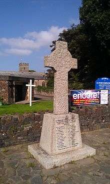
- Major Edward John Arundell Clarke (1868–1932),[42] of Fremington House,[43] and Brookfield House, Fremington, was the eldest son of Edward Clarke (died 1895), a solicitor, of Avishays, Chaffcombe, Chard, Somerset,[44] by his wife Barbara Yeo (died 1898), youngest daughter of William I Arundell Yeo (died 1862).[45] He was a JP for Devon and a major in the Royal North Devon Yeomanry. He married Violet Press, by whom he had a son John Arundell Clarke (born 1899) and a daughter Barbara Arundell Clarke (alive in 1968), who in 1919 married Sir John Stuart Page-Wood, 6th Baronet (1898–1955).[43] The North Devon Journal reported that on Armistice Day 1923 Fremington's war memorial was unveiled by Major Arundell Clarke.[46]
- Constance Barbara Clarke (1867–1931),[47] (eldest sister), of Fremington House, eldest daughter of Edward Clarke (died 1895), of Avishays, Chard, Somerset,[44] and a granddaughter of William I Arundell Yeo (died 1862),[48] inherited the manor of Fremington and Dinham House in Cornwall[49] (a former Arundell family estate). She married twice, firstly on 6 March 1905 to Admiral Sir John Erskine Kennedy Baird (1832–1908), son of Sir David Baird, 2nd Baronet (1795–1852), of Newbyth, by his wife Lady Anne Kennedy. Secondly on 15 December 1925 she married Charles Kennedy, 5th Marquess of Ailsa (1875–1956).[50] Following the death in Ontario[51] of Constance Clarke in 1931 the remnant of the manor left unsold by Miss Yeo was sold to Mr Fred Holland, including Fremington House and about 60 acres of land.[48]
US Army
Between 1943 and 1945 Fremington House and grounds was used by the US army as "Fremington Training Camp", a hospital and rehabilitation centre.[52]
British Army
On the departure of the US Army in 1945, Fremington House and grounds were used by the British Army as the "School of Combined Operations", commanded by an Admiral. In the late 1950s it was used by Amphibious Squadrons of the Royal Army Service Corps and Royal Corps of Transport. The mansion house served as the officers mess of 18 Company (Amphibian).[52] In the 1970s it served as an Army training camp. In 1980 Fremington House was sold by the Army and became a nursing home.[46] The army camp, which occupied about 50 acres of land, remained, but closed on 1 October 2009. It had undergone a review by Defence Training Estates South West was said by David Harris, South West Army spokesman, to be "past its sell by date". He added: "The Fremington site is worn out and has come to the end of its economic life...Buildings at the camp are 1940s stock, old wooden huts that are very expensive to maintain. It's just not worth pumping any more money into...The camp is largely seasonal, with the majority of occupation taking place in the summer months".[53]
Railway

The Tarka Trail cycle track (also part of the South West Coast Path), which follows the course of the railway from Barnstaple to Torrington, passes over Fremington Pill via the old London and South Western Railway iron bridge (railway line closed 1982; dismantled 1987) at Fremington Quay on the old Barnstaple to Torrington railtrack bed. The original railway was first planned in an Act of Parliament in 1838, and laid in 1846 connecting the Penhill with Barnstaple at a cost of £20 000. A number of boats are moored here (in the Pill). The 'Quay Cafe' is located here. Whilst rather charmingly built in the style of a railway station, it is not the original one which was located the other side of the Tarka Trail where an original platform still exists. Other features around the Pill include a couple of Lime kilns, now thoroughly fenced off to prevent accidents. The station was one stop after the still active railway station of Barnstaple, to which Fremington is linked directly by the wide scenic path described instead.
Army Camp
Fremington Army Camp was located here to be within easy marching distance (800 m) from the railway station at the Quay. The site was used by the US Army's 313th Station Hospital for post-D-Day rehabilitation, with room for 2,000 patients. It started receiving casualties on 20 July 1944.
It economically was complemented by the still current Marines and Air Force presence at Royal Marines Base Chivenor, a mile (2 km) northwards on the opposite bank of the River Taw, and the Amphibious Trials and Training Unit of the Royal Marines at Arromanches Camp, Instow, 2 miles (4 km) to the west. The camp was closed in autumn 2009.
References
- Pauline Brain Some Men who Made Barnstaple N. Devon Art Potters, 2010
- US Army history R. L. Diveley & M. Cleveland. Surgery in World War II, Volume II, Chapter 6.
- ↑ 2011 Census Retrieved 21 February 2015
- ↑ "Ward population 2011". Retrieved 19 February 2015.
- ↑ Hoskins, W.G., A New Survey of England: Devon, London, 1959 (first published 1954), p.399
- ↑ Hoskins. p.399
- ↑ (Campbell et al., 1998, Quaternary of South West England). Rare (for south-western England)
- ↑ "Fremington through time : Population Statistics : Total Population". A Vision of Britain through Time. Retrieved 13 July 2013.
- 1 2 Samuel Lewis (1848) Topographical Dictionary of England, 7th ed.
- ↑ fremingtoncommunity.com Retrieved 15 July 2013
- ↑ Risdon, Tristram (died 1640), Survey of Devon, 1811 edition, London, 1811, with 1810 Additions, p.286
- ↑ History of Parliament biography of John Stourton (died 1438)
- ↑ Vivian, Lt.Col. J.L., (Ed.) The Visitations of the County of Devon: Comprising the Heralds' Visitations of 1531, 1564 & 1620, Exeter, 1895, pp.3–8
- ↑ See crest of Acland of Fremington (a wyvern) on archway to rear service yard at Fremington House. The crest of Acland of Acland is a man's gloved hand holding a falcon
- 1 2 http://www.historyofparliamentonline.org/volume/1690-1715/member/acland-richard-1679-1729
- ↑ Lamplugh, Lois, Barnstaple: Town on the Taw, South Molton, 2002, List of Mayors, p.157
- ↑ http://www.foda.org.uk (Devon Freeholders Book, 1733, QS7/14
- 1 2 White's Directory, 1878
- 1 2 Summers, Peter & Titterton, John, (eds.), Hatchments in Britain, Vol.7: Cornwall, Devon, Dorset, Gloucestershire, Hampshire, Isle of Wight and Somerset; Phillimore Press, Chichester, Sussex, 1988, p.24, no.3, but with Lovering arms given incorrectly as Hussey
- ↑ Risdon, p.423
- ↑ Burke's General Armory, 1884, p.46
- ↑ Lysons, Magna Britannia, Vol.6: Devon, "Gentry"
- ↑ http://www.mocavo.com/Biographical-History-of-Gonville-and-Caius-College-1349-1897-Containing-a-List-of-All-Known-Members-of-the-College-From-the-Foundation-to-the-Present-Time-With-Biographical-Notes-Volume-2/605915/68
- ↑ Dates per his mural monument in St Peter's Church, Fremington
- ↑ Stated in the 1810 Additions to Risdon's Survey of Devon (p.428) to have owned Rawleigh House, Pilton, but statement withdrawn by Corrigenda, p.443. His widow Jane did however certainly die at Rawleigh House, as is recorded by her mural monument in St Peter's Church, Fremington
- ↑ "Brandymire" per Risdon, pp.423–4
- ↑ Risdon, Tristram (died 1640), Survey of Devon, 1811 edition, London, 1811, with 1810 Additions, p.432
- ↑ Risdon, p.424
- ↑ Nicholas, Thomas, Annals and Antiquities of the Counties and County Families of Wales, p.617
- ↑ Davies, Peter, The History of Beaufort Lodge – No.443
- ↑ Burke's Genealogical and Heraldic History of the Landed Gentry, 15th Edition, ed. Pirie-Gordon, H., London, 1937, pp.1241–2)
- ↑ Will at North Devon Record Office
- ↑ National Archives, Kew, Mackenzie v Yeo, PROB 37/1421
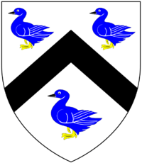
- ↑ Per research conducted by Sheila Yeo of the Yeo Society , based on stained glass depictions of Yeo arms in churches of Petrockstowe (Yeo of Heanton Satchville) and Hatherleigh (Yeo of Hatherleigh) both in Devon. The ducks are described as of various breeds by different sources. Heraldic sources give contradictory tinctures: Argent, a chevron between three shovelers sable (Vivian, Lt.Col. J.L., (Ed.) The Visitations of the County of Devon: Comprising the Heralds' Visitations of 1531, 1564 & 1620, Exeter, 1895, p.834) and Argent, a chevron between three mallards azure (Pole, Sir William (died 1635), Collections Towards a Description of the County of Devon, Sir John-William de la Pole (ed.), London, 1791, p.510)
- ↑ Vivian, Lt.Col. J.L., (Ed.) The Visitations of the County of Devon: Comprising the Heralds' Visitations of 1531, 1564 & 1620, Exeter, 1895, p.834
- ↑ Vivian, Lt.Col. J.L., (Ed.) The Visitations of the County of Devon: Comprising the Heralds' Visitations of 1531, 1564 & 1620, Exeter, 1895, pp.834–839, pedigree of Yeo
- ↑ Vivian, Lt.Col. J.L., (Ed.) The Visitations of the County of Devon: Comprising the Heralds' Visitations of 1531, 1564 & 1620, Exeter, 1895, p.836, pedigree of Yeo
- ↑ Vivian, p.836 & www.yeosociety.com
- ↑ Christie, Peter, A North Devon Chronology. From The Heritage Album: 175 years in North Devon (1824–1999)
- ↑ Hockey & Michelmore, St Peter's Fremington, Notes on its Historical Associations, 2nd revised edition, 2000, p.17
- ↑ Summers, Peter & Titterton, John, (eds.), Hatchments in Britain, Vol.7: Cornwall, Devon, Dorset, Gloucestershire, Hampshire, Isle of Wight and Somerset; Phillimore Press, Chichester, Sussex, 1988, p.24
- ↑
- ↑ Hockey & Michelmore, St Peter's Fremington, Notes on its Historical Associations, 2nd revised edition, 2000, p.4
- ↑ date of death per
- 1 2 Montague-Smith, P.W. (ed.), Debrett's Peerage, Baronetage, Knightage and Companionage, Kelly's Directories Ltd, Kingston-upon-Thames, 1968, p.875, Page-Wood Baronets
- 1 2 Montague-Smith, P.W. (ed.), Debrett's Peerage, Baronetage, Knightage and Companionage, Kelly's Directories Ltd, Kingston-upon-Thames, 1968, p.47, Marquess of Ailsa
- ↑ Walford's The County Families of the United Kingdom, 59th edition, London, 1919, p.266
- 1 2 Christie
- ↑ date of birth per
- 1 2 Hockey & Michelmore, St Peter's Fremington, Notes on its Historical Associations, 2nd revised edition, 2000, p.5
- ↑ Per
- ↑ http://www.thepeerage.com/p2564.htm
- ↑ Place of death per
- 1 2 http://18coyrasc.btck.co.uk/HISTORYOF116COY18COYSQNANDFREMINGTONCAMP
- ↑ http://www.exeterexpressandecho.co.uk/jobs-Fremington-army-camp-closes/story-11800661-detail/story.html
External links
| Wikimedia Commons has media related to Fremington, Devon. |
- Fremington, Devon at DMOZ
- Devon County Council Local History of Fremington
- GENUKI entry for Fremington
- Devon Tradition: An Anthology from Traditional Singers