Fremington, North Yorkshire

Coordinates: 54°23′08″N 1°55′49″W / 54.38547°N 1.9303°W
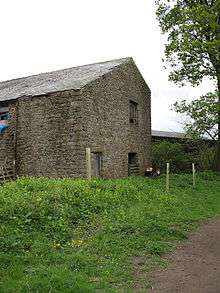
The old village cornmill, driven by the Arkle Beck, now a barn
Fremington is a hamlet in the Yorkshire Dales in North Yorkshire, England.[1][2] The hamlet is almost joined to Reeth and Grinton. It is split into Low Fremington which is built along the B6270 and High Fremington which is a scattering of houses running up towards Fremington Edge.
The origin of the place-name is from the Old English words Fremi (or Frema), ing and tun and means estate associated with a man named Fremi (or Frema). It appears as Fremington in the Domesday Book of 1086.[3]
References
- ↑ Ordnance Survey: Landranger map sheet 98 Wensleydale & Upper Wharfedale (Map). Ordnance Survey. 2009. ISBN 9780319231586.
- ↑ "Ordnance Survey: 1:50,000 Scale Gazetteer" (csv (download)). www.ordnancesurvey.co.uk. Ordnance Survey. 1 January 2016. Retrieved 18 February 2016.
- ↑ Mills, A.D. (2011) [first published 1991]. A Dictionary of British Place Names (First edition revised 2011 ed.). Oxford: Oxford University Press. p. 195. ISBN 9780199609086.
External links
![]() Media related to Fremington, North Yorkshire at Wikimedia Commons
Media related to Fremington, North Yorkshire at Wikimedia Commons
This article is issued from Wikipedia - version of the 2/21/2016. The text is available under the Creative Commons Attribution/Share Alike but additional terms may apply for the media files.