Beavertail State Park
| Beavertail State Park | |
| Rhode Island State Park | |
 | |
| Country | |
|---|---|
| State | |
| County | Newport |
| Town | Jamestown |
| Elevation | 10 ft (3 m) [1] |
| Coordinates | 41°26′56″N 71°23′58″W / 41.44889°N 71.39944°WCoordinates: 41°26′56″N 71°23′58″W / 41.44889°N 71.39944°W [1] |
| Area | 153 acres (62 ha) |
| Established | 1980 |
| Management | Rhode Island Department of Environmental Management Division of Parks & Recreation |
 Location in Rhode Island
| |
| Website: Beavertail State Park | |
Beavertail State Park is a Rhode Island state park encompassing 153 acres (62 ha) at the southern end of Conanicut Island in Narragansett Bay. Its main attraction is the active Beavertail Lighthouse, the current tower of which dates from 1856. During World War II, the park area was part of Fort Burnside, one of several coastal fortifications designed to protect Narragansett Bay.[2] The park's scenic shoreline offers hiking, picnicking, and saltwater fishing.[3]
History
- Lighthouse
A 58-foot wooden tower built in 1749, under the direction of architect Peter Harrison of Newport, burnt down in 1753. It was replaced by a fieldstone tower which was in use until 1856, when the present tower and keeper's quarters were completed.[4] The assistant keeper's house, which was built in 1898, now houses the Beavertail Lighthouse Museum.[5]
- Coastal fortification

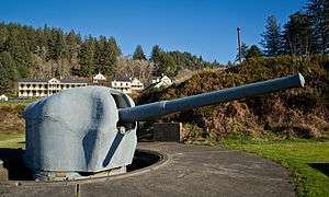
Fort Burnside was established in 1942 as part of the Harbor Defenses of Narragansett Bay. By late 1943, a battery of two 6-inch guns (152 mm) and a battery of two 3-inch guns (76 mm) were established. The 6-inch battery was called Battery Construction Number (BCN) 213, with ammunition magazines in a large bunker and the guns in shielded mounts. The 3-inch battery was called Battery Whiting; the guns were relocated from Fort Getty and the battery name was retained. A large Army-Navy Harbor Entrance Control Post, disguised as a seaside mansion, was also built and still exists. A battery of two 16-inch guns (406 mm), similar to those at Fort Church and Fort Greene and called BCN 110, was proposed for Fort Burnside but never built.[6][7] With the war over, Fort Burnside's guns were scrapped in 1948.
- Radio station
From circa 1960 to 1974, part of the former Fort Burnside was used for the Naval Radio Station (NAVRADSTA) Jamestown, part of Naval Communications Station (NAVCOMMSTA) Newport. It had a distinctive 600-foot (180-meter) radio tower.[8]
- State park
The state created Beavertail State Park in 1980, after the site was declared federal surplus land.[2] The park is used for sightseeing, hiking, picnicking, and saltwater fishing. Nature programs are offered seasonally.[3]
See also
References
- 1 2 "Beavertail Point". Geographic Names Information System. United States Geological Survey.
- 1 2 "Beavertail State Park History". State of Rhode Island Division of Parks & Recreation. Retrieved 8 December 2012.
- 1 2 "Beavertail State Park". State of Rhode Island Division of Parks & Recreation. Retrieved 8 December 2012.
- ↑ "Beavertail Light" (PDF). National Register of Historic Places Nomination Form. Rhode Island Preservation. April 1977. Retrieved 9 November 2015.
- ↑ "Lighthouse Museum". Beavertail Lighthouse Museum Association. Retrieved 9 November 2015.
- ↑ "Fort Burnside". FortWiki. Retrieved 26 October 2015.
- ↑ Berhow, p. 205
- Berhow, Mark A., Ed. (2004). American Seacoast Defenses, A Reference Guide, Second Edition. CDSG Press. ISBN 0-9748167-0-1.
- Lewis, Emanuel Raymond (1979). Seacoast Fortifications of the United States. Annapolis: Leeward Publications. ISBN 978-0-929521-11-4.
External links
- Beavertail State Park Rhode Island Department of Environmental Management Division of Parks & Recreation
- List of all US coastal forts and batteries at the Coast Defense Study Group, Inc. website
- FortWiki, lists all CONUS and Canadian forts
| Wikimedia Commons has media related to Beavertail State Park. |