Foreste Casentinesi, Monte Falterona, Campigna National Park
| Parco Nazionale delle Foreste Casentinesi, Monte Falterona, Campigna | |
|---|---|
|
IUCN category II (national park) | |
|
View of the park | |
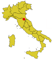 Location of the park | |
| Location | Emilia Romagna, Tuscany |
| Nearest city | Florence |
| Area | 368 km2 (142 sq mi) |
| Established | 1993 |
| Governing body | Ministero dell'Ambiente |
| http://www.parks.it/parco.nazionale.for.casentinesi/Eindex.html | |
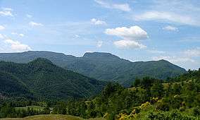
The Parco Nazionale delle Foreste Casentinesi, Monte Falterona, Campigna is a national park in Italy. Created in 1993, it covers an area of about 368 square kilometres (142 sq mi),[1] on the two sides of the Apennine watershed between Romagna and Tuscany, and is divided between the provinces of Forlì Cesena, Arezzo and Florence.
It extends around the long ridge, descending steeply along the parallel valleys of the Romagna side and more gradually on the Tuscan side, which has gentler slopes, especially in the Casentino area, which slopes down gradually to the broad valley of the Arno.
Places of interest
- Campigna - white fir
- Acquacheta - waterfall, mentioned in Dante's Comedy
- Badia Prataglia - beech wood
- Camaldoli - monastery
- Fiumicello - mill
- Valbonella Botanical Gardens - botanical garden near Corniolo
- Siemoni Arboretum - museum and historic arboretum located in Badia Prataglia
- Tredozio- Tramazzo River Valley
- Chiusi della Verna - Franciscan places
- Castagno d'Andrea - chestnut wood
- Ridracoli - lake and dam
- Foresta della Lama - wildlife
- Sasso Fratino - first integral nature reserve in Italy (1959)
- Springs of Tiber River - Mount Fumaiolo
- Springs of Arno River - Monte Falterona

Wildlife
A large part of the park is woodland. In the park are areas the mountain vegetation, all types of woodland of the lower sub-mountain belt vegetation. In the forest dominated by hornbeams, turkey oaks and sessile oaks, chestnut woods (especially in the Camaldoli area and at Castagno d’Andrea on the Florentine side). In rocky places there are some of remaining rare cork oaks . Flora inside park include over 1000 herbaceous species, of which 48 are trees and shrubs. The most valuable collection is to be found in the Mount Falco-Falterona massif.[2]
- Apennines wolf
- Barn owl
- Boar
- Common buzzard
- Eagle
- Eurasian badger
- Fallow deer
- Marten
- Red deer
- Red fox
- Roe deer
- Tawny owl
References
- ↑ Fonte: Piano del Parco in vigore. Relazione generale - 28 marzo 2002, approvato dalle Regioni Emilia-Romagna e Toscana. p. 20
- ↑ http://www.parcoforestecasentinesi.it/pfc/index.php?option=com_content&task=view&id=71&Itemid=29&jos_change_template=pfc_territorio&lang=en flora
| Wikimedia Commons has media related to Foreste Casentinesi, Monte Falterona, Campigna National Park. |
External links
- Official website (Italian) (English)
- Pages by the Park Authority on Parks.it
Coordinates: 43°50′36″N 11°47′28″E / 43.84333°N 11.79111°E
