Sila National Park
| Parco Nazionale della Sila | |
|---|---|
|
IUCN category II (national park) | |
|
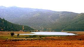
Lake Ariamacina, Sila National Park | |
 Sila Location of park | |
| Location | Calabria |
| Nearest city | Crotone |
| Coordinates | 39°22′34″N 16°35′31″E / 39.37611°N 16.59194°ECoordinates: 39°22′34″N 16°35′31″E / 39.37611°N 16.59194°E |
| Area | 736.95 km2 (284.54 sq mi) |
| Established | 1997 |
| Governing body | Ministero dell'Ambiente |
| http://www.parks.it/parco.nazionale.sila/Eindex.php | |
Sila National Park was established in 1997 and covers about 74,000 ha in Calabria. Its highest mountains are Mt. Botte Donato (1,928m), in Sila Grande, and Mt. Gariglione (1,764m) in Sila Piccola.
During a 2010 air analysis, nanopathologists[1] found that a particular area in the Sila National Park had the cleanest air in Europe.[2][3][4][5][6][7]
References
- ↑ https://ec.europa.eu/research/quality-of-life/ka4/pdf/report_nanopathology_en.pdf
- ↑ "Sila – Welcome to Santa Monica Resort & Village".
- ↑ "The Sila: A National Park in Calabria not to miss!". 29 November 2015.
- ↑ "Special offers, last minute, discounts and promotions Sila National Park".
- ↑ http://www.calabriataste-meals.co.uk/blog/sila-national-park
- ↑ "The Sila and its extraordinary beauty". 17 November 2014.
- ↑ "Sila – Visit Calabria".
- Yearbook of the Italian Parks 2005, edited by Comunicazione in association with Federparchi and the Italian State Tourism Board ISBN 88-7585-011-9
External links

This article is issued from Wikipedia - version of the 11/19/2016. The text is available under the Creative Commons Attribution/Share Alike but additional terms may apply for the media files.