Flagstaff Lake (Maine)
| Flagstaff | |
|---|---|
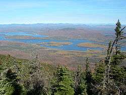 Flagstaff Lake seen from Mount Bigelow | |
| Location | Northwest Somerset, Somerset County, and Eustis, Franklin County, Maine, US |
| Coordinates | 45°11′38.9″N 70°18′52.4″W / 45.194139°N 70.314556°WCoordinates: 45°11′38.9″N 70°18′52.4″W / 45.194139°N 70.314556°W |
| Type | eutrophic, reservoir, natural lake |
| Primary inflows | North Branch Dead River; South Branch Dead River |
| Primary outflows | Dead River |
| Catchment area | 516 square miles (1,340 km2) |
| Basin countries | United States |
| Surface area | 20,300 acres (8,200 ha) |
| Average depth | 18 feet (5.5 m) |
| Max. depth | 48 feet (15 m) |
| Water volume | 261,365 acre·ft (322,389,000 m3) |
| Residence time | 6 months |
| Shore length1 | 147.2 miles (236.9 km) |
| Surface elevation | 1,146 feet (349 m) |
| 1 Shore length is not a well-defined measure. | |
Flagstaff Lake is located in Somerset County and Franklin County, Maine in the United States. The North Branch Dead River and South Branch Dead River join in the lake, forming the Dead River.
The lake's surface area is 20,300 acres (82 km2), and it has a storage capacity of about 275,482 acre-feet. It is extremely shallow (more so during drought years). Its deepest point is 48 feet (15 m).[1] Landlocked salmon and brook trout can be caught. Some points on the lake are very marshy and have to be negotiated with a canoe or kayak; even then, wading may be necessary in the marshy areas to get through to the rest of the lake.
Bigelow Mountain Range overlooks from the lake's southern shore, which makes the lake popular for outdoor activities.
Long Falls Dam
Flagstaff Lake was a smaller natural lake when the Long Falls Dam impounded the Dead River in 1950,[2] enlarging the lake and turning it into a reservoir used for hydropower electricity production by regulating the flow of the Dead River into the Kennebec River.[3] At the time, the river drive was still a primary means of delivering timber to the pulp mills downstream. Improved highways and the trucking industry have replaced the river drive.
Construction was controversial dating back to 1923, pitting the president of Central Maine Power Company, Walter Wyman, against state legislator and future Maine governor Percival Proctor Baxter.[4] Flagstaff Lake occupies parts of the abandoned and now submerged townships of Flagstaff, Bigelow, Dead River and Carrying Place.[5]
The dam is 45 feet high, 1339 feet long at its crest, and consists of a 450-foot concrete spillway, a 125-foot-long concrete section containing five 20-foot-wide Tainter gates, a 70-foot-long concrete section containing two Broome gates, a fishway, and a log sluice, and a 694-foot-long earthen dike.[6] The dam is owned and operated by NextEra Energy,[7] but no electricity is generated here. The dam is operated to regulate and augment flows that are used by eight downstream mainstem Kennebec River hydropower projects, and to control flooding.[8]
1959 Air Accident


A mid-air collision occurred over the lake during a United States Air Force exercise on the evening of 3 November 1959. A Lockheed T-33 Shooting Star simulated an enemy aircraft approaching from the east while ground-controlled interception directed Convair F-102 Delta Daggers of the 37th Fighter-Interceptor Squadron from Burlington International Airport to intercept it. One of the F-102s pressed a simulated firing run too close as the interception occurred over the lake, and the F-102 delta wing cut the tail off the T-33. The T-33 crew ejected successfully, but the rear seat crewman died when he became tangled in his parachute and landed upside down near the front section of the T-33. The front half of the T-33 was discovered in 1959, and the back half was discovered a few years later. The F-102 aircraft was discovered in Flagstaff Lake in 1976, but the pilot was never found.[9]
References
- ↑ Maine Fishing Depth Maps: Lakes & Ponds by County. DeLorme. 2007. ISBN 978-0-89933-350-2.
- ↑ Patrick, Ruth (1994). Rivers of the United States: The eastern and southeastern states; Volume 3 of Rivers of the United States. John Wiley and Sons. p. 74. ISBN 978-0-471-30346-6.
- ↑ "The Northern: The Way I Remember" (PDF). John E. Mcleod. Retrieved 2012-12-19.
- ↑ Lost Villages of Flagstaff Lake, bBy Alan L. Burnell, Kenny R. Wing, page 9
- ↑ http://umaine.edu/folklife/maine-song-and-story-sampler-map/places/flagstaff-man-made-lake/
- ↑ http://www.gpo.gov/fdsys/pkg/FR-1996-09-09/html/96-22913.htm
- ↑ http://bangordailynews.com/2012/01/04/environment/conservation-group-accuses-dep-of-intentionally-relinquishing-oversight-of-flagstaff-lake/?ref=relatedBox
- ↑ Maine's Multiple Use River: Kennebec River, Past and Present. Kennebec Water Power Co. Lewiston, Maine
- ↑ "T-33A crash mystery". Pete Noddin. Retrieved 2012-01-20.