Etna Green, Indiana
| Town of Etna Green, Indiana | |
|---|---|
| Town | |
|
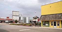
Downtown Etna Green | |
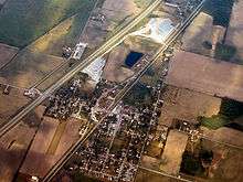
 Location in the state of Indiana | |
| Coordinates: 41°16′39″N 86°2′51″W / 41.27750°N 86.04750°WCoordinates: 41°16′39″N 86°2′51″W / 41.27750°N 86.04750°W | |
| Country | United States |
| State | Indiana |
| County | Kosciusko |
| Township | Etna |
| Area[1] | |
| • Total | 0.51 sq mi (1.32 km2) |
| • Land | 0.51 sq mi (1.32 km2) |
| • Water | 0 sq mi (0 km2) |
| Elevation | 817 ft (249 m) |
| Population (2010)[2] | |
| • Total | 586 |
| • Estimate (2012[3]) | 584 |
| • Density | 1,149.0/sq mi (443.6/km2) |
| Time zone | EST (UTC-5) |
| • Summer (DST) | EST (UTC-5) |
| ZIP code | 46524 |
| Area code(s) | 574 |
| FIPS code | 18-21502[4] |
| GNIS feature ID | 0452111[5] |
Etna Green is a town in Etna Township, Kosciusko County, Indiana, United States. The population was 586 at the 2010 census. Etna Green belongs to Triton School Corporation.
History
Etna Green was laid out in 1853.[6] It took its name from Etna Township.[7] The Etna Green post office was established in 1854.[8]
Geography
Etna Green is located at 41°16′39″N 86°2′51″W / 41.27750°N 86.04750°W (41.277545, -86.047629).[9]
According to the 2010 census, Etna Green has a total area of 0.51 square miles (1.32 km2), all land.[1]
Demographics
| Historical population | |||
|---|---|---|---|
| Census | Pop. | %± | |
| 1870 | 397 | — | |
| 1880 | 388 | −2.3% | |
| 1890 | 411 | 5.9% | |
| 1900 | 420 | 2.2% | |
| 1910 | 431 | 2.6% | |
| 1920 | 357 | −17.2% | |
| 1930 | 371 | 3.9% | |
| 1940 | 423 | 14.0% | |
| 1950 | 444 | 5.0% | |
| 1960 | 483 | 8.8% | |
| 1970 | 516 | 6.8% | |
| 1980 | 522 | 1.2% | |
| 1990 | 578 | 10.7% | |
| 2000 | 663 | 14.7% | |
| 2010 | 586 | −11.6% | |
| Est. 2015 | 585 | [10] | −0.2% |
2010 census
As of the census[2] of 2010, there were 586 people, 219 households, and 159 families residing in the town. The population density was 1,149.0 inhabitants per square mile (443.6/km2). There were 245 housing units at an average density of 480.4 per square mile (185.5/km2). The racial makeup of the town was 97.8% White, 0.5% African American, 0.3% Native American, 0.3% Asian, 0.5% from other races, and 0.5% from two or more races. Hispanic or Latino of any race were 2.4% of the population.
There were 219 households of which 37.0% had children under the age of 18 living with them, 52.5% were married couples living together, 11.4% had a female householder with no husband present, 8.7% had a male householder with no wife present, and 27.4% were non-families. 23.3% of all households were made up of individuals and 7.8% had someone living alone who was 65 years of age or older. The average household size was 2.64 and the average family size was 3.09.
The median age in the town was 35.9 years. 27.3% of residents were under the age of 18; 9.4% were between the ages of 18 and 24; 24.8% were from 25 to 44; 26.7% were from 45 to 64; and 11.9% were 65 years of age or older. The gender makeup of the town was 49.8% male and 50.2% female.
2000 census
As of the census[4] of 2000, there were 663 people, 234 households, and 165 families residing in the town. The population density was 1,411.3 people per square mile (544.7/km²). There were 251 housing units at an average density of 534.3 per square mile (206.2/km²). The racial makeup of the town was 96.98% White, 0.45% African American, 0.30% Native American, 0.75% Asian, 1.21% from other races, and 0.30% from two or more races. Hispanic or Latino of any race were 2.87% of the population.
There were 234 households out of which 42.3% had children under the age of 18 living with them, 52.6% were married couples living together, 13.7% had a female householder with no husband present, and 29.1% were non-families. 21.4% of all households were made up of individuals and 9.4% had someone living alone who was 65 years of age or older. The average household size was 2.80 and the average family size was 3.33.
In the town the population was spread out with 33.3% under the age of 18, 8.1% from 18 to 24, 30.3% from 25 to 44, 17.6% from 45 to 64, and 10.6% who were 65 years of age or older. The median age was 30 years. For every 100 females there were 102.8 males. For every 100 females age 18 and over, there were 92.2 males.
The median income for a household in the town was $35,625, and the median income for a family was $35,139. Males had a median income of $34,000 versus $21,339 for females. The per capita income for the town was $14,110. About 3.1% of families and 4.9% of the population were below the poverty line, including 2.6% of those under age 18 and 9.2% of those age 65 or over.
References
- 1 2 "G001 - Geographic Identifiers - 2010 Census Summary File 1". United States Census Bureau. Retrieved 2015-07-16.
- 1 2 "American FactFinder". United States Census Bureau. Retrieved 2012-12-11.
- ↑ "Population Estimates". United States Census Bureau. Archived from the original on June 17, 2013. Retrieved 2013-06-25.
- 1 2 "American FactFinder". United States Census Bureau. Archived from the original on September 11, 2013. Retrieved 2008-01-31.
- ↑ "US Board on Geographic Names". United States Geological Survey. 2007-10-25. Retrieved 2008-01-31.
- ↑ Biographical and Historical Record of Kosciusko County, Indiana. Lewis Publishing Company. 1887. p. 713.
- ↑ Baker, Ronald L. (October 1995). From Needmore to Prosperity: Hoosier Place Names in Folklore and History. Indiana University Press. p. 127. ISBN 978-0-253-32866-3.
The town is located in Etna Township, for which it was named.
- ↑ "Kosciusko County". Jim Forte Postal History. Retrieved 25 November 2014.
- ↑ "US Gazetteer files: 2010, 2000, and 1990". United States Census Bureau. 2011-02-12. Retrieved 2011-04-23.
- ↑ "Annual Estimates of the Resident Population for Incorporated Places: April 1, 2010 to July 1, 2015". Retrieved July 2, 2016.
- ↑ "Census of Population and Housing". Census.gov. Archived from the original on May 11, 2015. Retrieved June 4, 2015.
Municipalities and communities of Kosciusko County, Indiana, United States | ||
|---|---|---|
| Cities | ||
| Towns | ||
| Townships | ||
| Unincorporated communities |
| |
| Footnotes | ‡This populated place also has portions in an adjacent county or counties | |