Elkin's Ferry Battleground
|
Elkins' Ferry | |
 | |
  | |
| Nearest city | Prescott, Arkansas |
|---|---|
| Coordinates | 33°55′50″N 93°21′26″W / 33.93056°N 93.35722°WCoordinates: 33°55′50″N 93°21′26″W / 33.93056°N 93.35722°W |
| Area | 575 acres (233 ha) |
| Built | 1864 |
| NRHP Reference # | 94001182 |
| Significant dates | |
| Added to NRHP | April 19, 1994[1] |
| Designated NHL | April 19, 1994[2] |
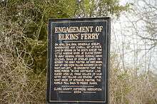
Elkin's Ferry was the site of the 1864 Battle of Elkin's Ferry, an engagement of the Camden Expedition during the American Civil War. The battlefield is located about 10 miles (16 km) north of Prescott, Arkansas, spanning the Little Missouri River in Clark and Nevada counties in Arkansas. The 575-acre (233 ha) battlefield area was designated a part of the Camden Expedition Sites, a National Historic Landmark District made up of several of expedition's key sites, in 1994.[2][3][4]
History
The 1864 Camden Expedition was part of a two-pronged strategy by the Union Army to drive Confederate resistance out of southwestern Arkansas and northern Louisiana, and pentetrated into Confederate Texas. Union Major General Frederick Steele led a Union force from Little Rock on March 23, 1864, with the objective of joining forces with Major General Nathaniel Prentice Banks at Shreveport, Louisiana. Confederate forces in Arkansas were directed from Washington, where the Confederate government of the state relocated after the fall of Little Rock. Confederate Major General Sterling Price ordered Brigadier General John S. Marmaduke to harry the Union column and to prevent it from crossing the Little Missouri River as it moved toward Washington. Advance Union forces established a beachhead on the south side of the Little Missouri on April 3, and clashed with Confederate defenders, who eventually withdrew upon the arrival of more of the Union column. Casualties were light: 18 Confederate soldiers killed and 50 wounded, and 30 Union soldiers wounded. The Union advance would be halted at Prairie D'Ane a week later, and eventually fail due to supply problems.[5][6]
Battlefield
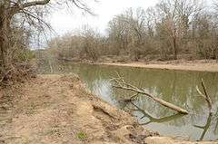
The battlefield is a predominantly wooded area, crossed by the Little Missouri River, and Middle and Howard Creeks, which are tributaries to its south that flow roughly from west to east. The present alignment of Nevada County Route 37 and Clark County Route 14 roughly follow the route the Union forces. The presumed ferry site is still visible as a deep cut in the river bank near the road. The ferry was replaced by a wooden bridge in the 1920s, which was washed out sometime in the 1950s or 1960s. The construction of Interstate 30 resulted in decreased significance of the area for transportation, and contributed to the preservation of the battlefield. The area is also flood-prone (as it was in the 1860s), and not suitable for development.[5]
See also
- List of National Historic Landmarks in Arkansas
- National Register of Historic Places listings in Nevada County, Arkansas
- National Register of Historic Places listings in Clark County, Arkansas
References
- ↑ National Park Service (2007-01-23). "National Register Information System". National Register of Historic Places. National Park Service.
- 1 2 "Camden Expedition Sites". National Historic Landmark summary listing. National Park Service. 2007-09-26.
- ↑ "National Register of Historic Places Inventory-Nomination: Camden Expedition Sites—Accompanying photos" (pdf). National Park Service. 1993.
- ↑ Bearss, Edward C.; Charleton, James H. (November 29, 1993). "National Historic Landmark Nomination: Camden Expedition Sites" (pdf). National Park Service.
- 1 2 "NRHP nomination for Elkin's Ferry Battleground" (PDF). Arkansas Preservation. Retrieved 2014-07-25.
- ↑ "NHL nomination for Camden Expedition Sites" (PDF). National Park Service. Retrieved 2014-07-25.
| Topics | |
|---|---|
| Lists by states |
|
| Lists by insular areas | |
| Lists by associated states | |
| Other areas | |
| |