Ballyhornan
| Ballyhornan | |
| Irish: baile an eoirna the town land of the barley | |
 Ballyhornan |
|
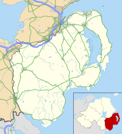
| District | Down District |
|---|---|
| County | County Down |
| Country | Northern Ireland |
| Sovereign state | United Kingdom |
| Postcode district | BT30 |
| Dialling code | 028 |
| EU Parliament | Northern Ireland |
| UK Parliament | South Down |
| NI Assembly | South Down |
|
|
Coordinates: 54°18′N 5°33′W / 54.3°N 5.55°W
Ballyhornan is a village and townland in eastern County Down, Northern Ireland, located along the coast of the Irish Sea. It has about 1,000 residents[1] and located less than 10 miles from Downpatrick, County Down. It lies near the site of the former RAF Bishopscourt installation, which closed in 1990, and much of the housing outside the boundaries of the traditional settlement (such as Killard Square) was used by RAF airmen.[2][3]
The core of the village is located at the extreme northern end of the Ardglass ward.[4]

Ballyhornan was founded in 1636, and a popular explanation of its name in Irish is Baile Uí Chornáin — Ó Cornáin's townland.[5] More recent research contends that the origin is Baile Torannan, or Toranan's town, referring to a sixth-century saint whose feast day is celebrated 12 August.[6]
After the closure of Bishopscourt, much of the housing was turned over to civilians, who bought a large portion of land whole. This, however, has led to problems of road maintenance, street lighting and other issues.[1]
The village currently experiences subpar sewer capacity, and residents continue to petition Northern Ireland politicians for funding for a new sewer system.[1]
Debate has taken place in the Northern Ireland Assembly about finding solutions to the situation in Ballyhornan; some politicians object to spending public funds in upgrading infrastructure because the roadways and sewage systems are privately owned, and they fear a knock-on effect would cause many private developments to seek similar relief.[3]
In the past, the village was considered a "deprived" area.[7] Changes have happened in the community in recent years, such as the opening of the Ballyhornan Family Centre and projects the center undertakes.[8][9] Development is ongoing, and Down District Council has approved plans for a petrol station and garage in the village.[10]
Local landmarks

Ballyhornan is home to Cable Bar, which underwent a facelift is 2009. The local landmark takes its name from the undersea telecom cable that runs from the Cable House in Ballyhornan across to the Isle of Man. Cable Bar is a friendly and relaxing pub that has served the local community and visitors for many years and continues to do so.[11]
Ballyhornan also is home to the Mustard Seed House, a non-denominational, spiritual retreat home located not far from the beach.
Next to the helicopter pad for the former Bishopscourt air base is the Ballyhornan Community Centre.[12]

Guns Island
Located 200 yards from the shore of the Ballyhornan beach is Guns Island.[13] It is a known fishing spot.[14]
Killard Nature Reserve
About one mile north of the village along the Killard Road is the Killard Nature Reserve, run by Northern Ireland Environment Agency. Recorded history of the site dates back to 1403, and it has seen a number of uses—from hurling pitch to remote RAF radar station.[15] Unique flowers, birds and critters can be found in the nature reserve. Bird-watching is one of the main reasons people visit the site.[16]
The effects of the Ice Age also can be seen in the shape of the rocks at Killard Point.[17]
Transport
Ballyhornan is reachable by multiple trips daily on Ulsterbus to Downpatrick, with connecting services from the Downpatrick bus compound to Belfast and other towns in County Down.[18] Cable Bar serves as the terminus for the Ballyhornan bus routes.
| Wikimedia Commons has media related to Ballyhornan. |
References
- 1 2 3 "Ballyhornan: The 'lost village' of County Down - BBC News". Bbc.co.uk. 2012-05-22. Retrieved 2015-05-02.
- ↑ "Ards & Down 2015 | Down District: Ballyhornan | Planning Portal". Planningni.gov.uk. 2015-03-19. Retrieved 2015-05-02.
- 1 2 "BBC - Democracy Live - Neglect of Ballyhornan/Bishopscourt". News.bbc.co.uk. 2012-05-22. Retrieved 2015-05-02.
- ↑ "NINIS Home Page". Ninis.nisra.gov.uk. 2015-03-26. Retrieved 2015-05-02.
- ↑ Archived March 10, 2010, at the Wayback Machine.
- ↑ "Lecale Miscellany No. 11 - 1993". Lecalehistory.co.uk. Retrieved 2015-05-02.
- ↑ https://web.archive.org/web/20110629123859/http://archives.tcm.ie/downdemocrat/2002/02/26/story388.asp. Archived from the original on June 29, 2011. Retrieved July 31, 2010. Missing or empty
|title=(help) - ↑ "This Website is ungoing Maintenance". Ballyhornanfamilycentre.org. Retrieved 2015-05-02.
- ↑ Archived June 29, 2011, at the Wayback Machine.
- ↑ "Planning Victory For Community Around Ballyhornan at Cadogan Enright". Enright.ie. 2012-02-29. Retrieved 2015-05-02.
- ↑
- ↑ "BBC News - Ballyhornan: County Down's lost village". Bbc.co.uk. 2012-05-22. Retrieved 2015-05-02.
- ↑ "Google Maps". Maps.google.com. Retrieved 2015-05-02.
- ↑
- ↑ "Killard Nature Reserve". Ni-environment.gov.uk. 2010-02-05. Retrieved 2015-05-02.
- ↑ "Peregrine's Bird Blog: Killard Nature Reserve in May". Peregrinesbirdblog.blogspot.com. 2010-05-10. Retrieved 2015-05-02.
- ↑ https://web.archive.org/web/20110127013408/http://www.bbc.co.uk/blueprint/media/killard_point.shtml. Archived from the original on January 27, 2011. Retrieved August 11, 2010. Missing or empty
|title=(help) - ↑ https://web.archive.org/web/20090106095659/http://www.nirailways.co.uk/present/ULB_16B_O.asp. Archived from the original on January 6, 2009. Retrieved August 10, 2009. Missing or empty
|title=(help)