Ballygowan
| Ballygowan | |
| Irish: Baile Mhic Gabhann | |
.JPG) |
|
 Ballygowan |
|
| Population | 2,957 (2011 Census) |
|---|---|
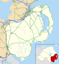
| District | Ards |
| County | County Down |
| Country | Northern Ireland |
| Sovereign state | United Kingdom |
| Post town | NEWTOWNARDS |
| Postcode district | BT23 |
| Dialling code | 028 |
| EU Parliament | Northern Ireland |
| UK Parliament | Strangford |
| NI Assembly | Strangford |
| Website | http://www.ballygowan.org.uk/ |
|
|
Coordinates: 54°30′N 5°48′W / 54.5°N 5.8°W
Ballygowan (from Irish Baile Mhic Gabhann, meaning "MacGabhann's town")[1] is a village and townland in County Down, Northern Ireland. It is within the Borough of Ards. The town of Comber is a short distance to the north-east, the town of Saintfield to the south, and the city of Belfast a further distance to the north-west. It is situated in the townland of the same name, the civil parishes of Killinchy and Comber and the historic barony of Castlereagh Lower.[2] Ballygowan is a busy commuter bypass and is said to border the 'Greater Belfast City District' providing excellent travelling distance to Belfast City Centre. Ballygowan is said to one of the most wealthy districts of County Down (based on household income), similar to that of North Down (Northern Ireland's most affluent borough). It had a population of 2,957 people in the 2011 Census.[3]
History
Prior to the Ulster-Scots settlement in the early 17th century, when a great number of Presbyterians moved over from the Scottish Lowlands to settle in North Down on lands granted by King James I to James Hamilton and Hugh Montgomery, the area surrounding Ballygowan was sparsely inhabited by subsepts of the great 'Neill clan of Castlereagh. Since the late 17th century the population has been predominantly Presbyterian.
In the late 18th century the village comprised a bridge (over the River Blackwater at the intersection of the Comber/Saintfield and Killyleagh/Belfast roads), a dozen or so small houses and an inn. The surrounding townlands were populated by a great number of small tenant farmers and weavers. The main landlords were Lord Dufferin and Lord Londonderry.
From the mid-19th century through the early 20th century the population of the rural area surrounding Ballygowan declined considerably as many people emigrated to North America or found work in Comber, Saintfield and particularly in Belfast. However, it was during this period, and subsequent to the introduction of the Belfast & County Down Railway in 1850, that the village began to grow. After the railway closed in 1950 the village became an attractive "dormitory" town and the ensuing 50 years have seen rapid growth. Ballygowan railway station opened on 10 September 1858, but finally closed on 16 January 1950.[4]
On Monday, 15th September 2014, the remains of The Baron Bannside (better known as The Rev. Ian Paisley) were buried in the graveyard attached to Ballygowan Free Presbyterian Church. Lord Bannside was a former First Minister of Northern Ireland and a former Leader of the D.U.P..
Population
2001 Census
In the 2001 Census Ballygowan had a population of 2671 people.
2011 Census
On Census Day (27 March 2011) the usually resident population of Ballygowan Ward was 2,957 (1,077 households).[3]
- 21.39% were aged under 16 years and 12.27% were aged 65 and over;
- 49.40% of the usually resident population were male and 50.60% were female; and 40 years was the average (median) age of the population.
- 99.09% were from the white (including Irish Traveller) ethnic group;
- 11.22% belong to or were brought up in the Catholic religion and
- 80.19% belong to or were brought up in a 'Protestant and Other Christian (including Christian related)' religion;
- 75.81% indicated that they had a British national identity, 7.12% had an Irish national identity and 33.69% had a Northern Irish national identity (Respondents could indicate more than one national identity)
Education
Ballygowan has two primary schools:
1. Alexander Dickson, in the centre of Ballygowan
2. Carrickmannon, a smaller school about 1 mile outside Ballygowan.
Railways
The Ballygowan railway station was opened by the Belfast and County Down Railway on 10 September 1858.[6] The station was on the once extensive network that connected Belfast Queen's Quay railway station to Downpatrick and Newcastle, County Down.
The station closed in 1950 under the auspices of the Ulster Transport Authority.
See also
| Wikimedia Commons has media related to Ballygowan. |
References
- ↑ Placenames NI
- ↑ "Ballygowan". Placenames database of Ireland. Retrieved 21 February 2013.
- 1 2 "Ballygowan". Census 2011 Results. NI Statistics and Research Agency. Retrieved 22 April 2015.
- ↑ "Ballygowan station" (PDF). Railscot - Irish Railways. Archived (PDF) from the original on 26 September 2007. Retrieved 2007-09-11.
- ↑ http://www.ninis2.nisra.gov.uk/public/AreaProfileReportViewer.aspx?FromAPAddressMulipleRecords=Ballygowan@Exact match of location name: @Exact Match Of Location Name: Ballygowan@4?
- ↑ "Ballygowan Halt station" (PDF). Railscot - Irish Railways. Retrieved 2012-05-06.