Saintfield
| Saintfield | |
| Irish: Tamhnaigh Naomh | |
 Main Street, Saintfield |
|
 |
|
| Population | 3,381 (2011 Census) |
|---|---|
| District | Down |
| County | County Down |
| Country | Northern Ireland |
| Sovereign state | United Kingdom |
| Post town | BALLYNAHINCH |
| Postcode district | BT24 |
| Dialling code | 028 |
| EU Parliament | Northern Ireland |
| UK Parliament | Strangford |
| NI Assembly | Strangford |
|
|
Coordinates: 54°28′N 5°50′W / 54.46°N 5.83°W
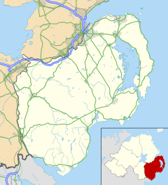
Saintfield is a village and civil parish in County Down, Northern Ireland. It is about halfway between Belfast and Downpatrick on the A7 road. It had a population of 3,381 in the 2011 Census, made up mostly of commuters working in both south and central Belfast, which is about 11 miles away. The population of the surrounding countryside is mostly involved in farming.
Running east to west across the A7 is the B6 road, and to the west of this crossroads is Main Street, which takes one towards Lisburn and Ballynahinch, and to the east is Station Road which takes one towards Killyleagh.
History
The area that is now Saintfield was historically called Tawnaghnym (recorded in 1605) or Taunaghnieve (recorded in 1663), which appear to derive from the Irish Tamhnach Naomh or Tamhnaigh Naomh, i.e. ‘field of saints’. The English translation, Saintfield, did not come into use until the 18th century.[1]
In the 16th century, the Saintfield area was part of South Clannaboy owned by Sir Con McNeil Oge O'Neil. His lands were confiscated after a false accusation of disloyalty in 1602 and were granted to Sir James Hamilton in 1605 who 'planted' English and Scottish settlers in the area.[2] Saintfield was originally an early 17th-century settlement, with the first church being built about 1633.[1] In 1709 Hamilton sold the estate to Major General Nicholas Price of Hollymount, County Down, who laid the foundations of the town and renamed it Saintfield in 1712.[2]
Nicholas Price remained owner of the village until his death in 1734 and encouraged linen manufacturers and tradesmen to settle, established a barracks, repaired the parish church and established markets and fairs.[2] The village had a number of corn, flour and flax mills, the remains of which are visible today, and has retained a tradition of textile manufacture through Saintfield Yarns. Development was continued by the Price family and in 1750 the family, headed by Francis Price, grandson of Nicholas, moved to a newly built Saintfield House, just north of the village.[2]
The Church of Ireland parish church (Main Street) was rebuilt in 1776 by the Price family and included part of a very old church. The First Presbyterian Church (also in Main Street) was built in 1777,[3] although a community of Presbyterians had been worshipping in the town since the early 17th-century. Its graveyard contains a plaque and gravestones relating to the burial place of United Irishmen killed at the Battle of Saintfield in June 1798.[3] A Roman Catholic church was built in 1787 as the Chapel of the Immaculate Heart of Mary, opposite the First Presbyterian Church, and is still used today as the Assumption Youth Hall. A new Roman Catholic Church (Mary Mother of the Church) was built in 1890 off the A7 road. A Second Presbyterian Church was built in 1796 on the Ballynahinch Road.[4] The architectural and historic significance of the town centre is reflected in its designation as a Conservation Area in 1997.
1798 in Saintfield

The Society of United Irishmen launched a rebellion in 1798, which began in Leinster and quickly spread to Ulster. The United Irishmen had been founded in 1791 by liberal Protestants in Belfast. Its goal was to unite Catholics and Protestants and make Ireland an independent republic. Although its membership in the South was mainly Catholic, most of its leaders and members in northeast Ulster were Protestant Presbyterians. On 9 June 1798, a British force was ambushed in a wood near Saintfield. About 100 men were killed altogether, and the United Irishmen emerged victorious. The headstones of men who were killed in this battle can be seen near the river at the bottom of the First Presbyterian Church graveyard. In the aftermath of the battle, Saintfield was sacked and only a few pre-1798 buildings remain.[2]
The village was subsequently rebuilt. In 1802 the Price family residence in Main Street was converted to an inn. In 1803 the Market House was built. The White Horse Inn was also built and almshouses in 1813. However, the village declined from the mid-19th century, with population reducing from 923 in 1851 to 533 just before the First World War.[2]
Places of interest

- Rowallane Garden is situated immediately south of the village on the A7 road and is a National Trust property.
- The old White Horse Inn also sits on the main street. Many of the buildings on the main street have old stables and courtyards behind them.
From Lewis Topographical Dictionary (1837): The proprietor and lord of the manor, N. Price, Esq., improved the town in 1802, when he erected a large market-house and hotel, since which time Saintfield has been rapidly improving, and is now one of the most flourishing towns in the county.
- The Market House (now an Orange Hall) and the Hotel (now a private house) can be seen on Main Street.
Demography
Saintfield is classified as an intermediate settlement by the NI Statistics and Research Agency (NISRA) (i.e. with population between 2,250 and 4,500 people). On Census day there were 3,381 people living in Saintfield. Of these:
- 19.48% were aged under 16 years and 21.83% were aged 60 and over,
- 48.4% of the population were male and 51.6% were female,
- 26.32% were from a Catholic background and 65.48% were from a Protestant background,
For more details on Saintfield's demographics see: NI Neighbourhood Information Service
- In 1837 the population of Saintfield area was 7,154 of whom 1,053 lived in the town.[5]
People

- Thomas Beattie MP, Member of the Canadian House of Commons, born in Saintfield
- Lynda Bryans, Television Presenter, from Saintfield
- Lord Faulkner, Prime Minister of Northern Ireland, died in a hunting accident at the Ballyagherty/Station Road junction just outside Saintfield.
- Francis Hutcheson, philosopher & teacher born at Drumalig
- William David Kenny, born in 1899 in Saintfield, was awarded the Victoria Cross for gallantry in India in 1918.
- Ewan McHenry, Folk singer-songwriter, from Saintfield
- Bishop Daniel Mageean, Bishop of Down & Connor, born at Darragh Cross
- J.R. (Jimmy) Mageean (1887-1972), actor with the Ulster Literary Theatre and actor/director with the Belfast Repertory Theatre and Group Theatre
- George Morrison, Unionist politician, raised in Saintfield
- Rev. Coslett Herbert Waddell, Vicar of Saintfield, botanist
Religion
Despite being a relatively small town, Saintfield is served by five well-attended churches: the local Church of Ireland, two Presbyterian churches, Saintfield Baptist Church and Mary, Mother of the Church Roman Catholic Church.
Education
Saintfield contains two primary schools 'Saintfield Academy Primary' and 'St. Marys' and one secondary school 'Saintfield High School', with a large amount of its under-18 population travelling to schools in Downpatrick, Ballynahinch or Belfast.
Primary
- Academy Primary School
- St. Caolan's Primary School, Darragh Cross
- Millennium Integrated Primary School
- St. Mary's Primary School

Secondary
Sport
 Saintfield Mens Hockey Club
- St. Mochais GAC
- Saintfield AYC Football Club
- Saintfield Bowling Club
- Saintfield Cricket Club
- 2nd Saintfield Badminton Club
- Saintfield Mens Hockey Club
- Saintfield Ladies Hockey Club
- Saintfield United Football Club
- Fishing at Carrickmannon Lake
Groups
- 1st Saintfield Scouts is based in Saintfield Parish hall with a great attendance. They celebrate their 100th anniversary in 2011 just 4years after the Scouts was founded.
- Saintfield Heritage Society (SHS)
- Saintfield Development Association (SDA)
Transport
Saintfield railway station opened on 10 September 1858 and finally closed on 16 January 1950.[6] The current main mode of transport is from the end of the main street on the A21/A7 which is a Translink service, Ulsterbus operates frequently to and from Belfast/Downpatrick.

See also
| Wikimedia Commons has media related to Saintfield. |
References
- 1 2 "Saintfield, County Down". Place Names NI. Retrieved 6 March 2015.
- 1 2 3 4 5 6 "Saintfield Conservation Area" (PDF). Planning NI. Retrieved 6 March 2015.
- 1 2 Sandford, Ernest (1976). Discover Northern Ireland. Belfast: NI Tourist Board. p. 198. ISBN 0 9500222 7 6.
- ↑ "Churches in Saintfield". Discover Saintfield. Retrieved 6 March 2015.
- ↑ Entry for Saintfield in Lewis Topographical Dictionary of Ireland (1837)
- ↑ "Saintfield station" (PDF). Railscot - Irish Railways. Retrieved 2007-11-24.
- Saintfield Heritage - a publication of the Saintfield Heritage Society. Books 1 - 7. Book 7 ISBN 0-9508620-6-1
External links
- DiscoverSaintfield.com THE #1 website for all things Saintfield. Site managed by Saintfield Town Regeneration Committee & Saintfield Heritage Society.
- First Saintfield Presbyterian Church
- Second Saintfield Presbyterian Church
- Saintfield United F.C.