Duchesne River
| Duchesne River | |
| Euwinty | |
| River | |
| | |
| Country | United States |
|---|---|
| State | Utah |
| Tributaries | |
| - left | Lake Fork River, Uinta River |
| - right | Strawberry River |
| Cities | Duchesne, Tabiona, Myton, Randlett, Hanna |
| Source | Uinta Mountains |
| - elevation | 10,093 ft (3,076 m) |
| - coordinates | 40°42′31″N 110°52′25″W / 40.70861°N 110.87361°W [1] |
| Mouth | Green River |
| - elevation | 4,652 ft (1,418 m) |
| - coordinates | 40°05′08″N 109°40′45″W / 40.08556°N 109.67917°WCoordinates: 40°05′08″N 109°40′45″W / 40.08556°N 109.67917°W |
| Length | 115 mi (185 km) [2] |
| Basin | 3,790 sq mi (9,816 km2) |
| Discharge | for Randlett |
| - average | 522 cu ft/s (15 m3/s) |
| - max | 11,500 cu ft/s (326 m3/s) |
| - min | 0.78 cu ft/s (0 m3/s) |
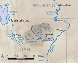 Map of the Duchesne River watershed | |
The Duchesne River, located in the Uintah Basin region of Utah in the western United States, is a tributary of the Green River. The watershed of the river covers the Northeastern corner of Utah. The Duchesne River is 115 miles (185 km) long,[2] and drains a total land area of 3,790 square miles (9,800 km2).
Geography
The Duchesne River begins in the Uinta Mountains in northern Utah. It first flows southeast, then turns east at the confluence of the Strawberry River which enters from the west. It picks up the Lake Fork River from the north near Myton and the Uinta River from the north at Randlett. Below Randlett it turns southeast, emptying into the Green River at Ouray. The Duchesne River proper flows through Duchesne and Uintah counties, although some of its watershed extend into Wasatch County.
The Yellowstone River is a major tributary of the Lake Fork, and the Whiterocks River flows into the Uinta River. Other major tributaries include Rock Creek, which flows into the Duchesne River southwest of Talmage, and Currant Creek, a tributary of the Strawberry River.
History
Named Santa Caterina de Sena by Dominguez-Escalante in September 1776, the river received its permanent name from early French American trappers who were from St. Louis, Missouri, but work out of Taos, New Mexico and followed the Old Spanish Trail north until they entered the Uintah Basin by way of the Book Cliffs in the south. From 1824 to 1840 the river and its tributaries provided tons of beaver pelts used to make hats. William Henry Ashley upon entering the Uinta Basin from the north in 1825 and exploring the branches of the Green River called the Duchesne branch the "Euwinty" river. The first reference to the "Duchesne Fork" is from a map created by Warren A Ferris in 1835.
In 1842 a map created by John C. Frémont labeled the main course of the river the Uintah River and starting at the fork where the current town of Duchesne is located, the northern fork is labeled "Duchesne Fork". The main course of the river continued to be called the Uintah River through the 1860s until the first Indian agency was created. US Army engineer Captain Simpson 10th infantry listed it as Des Chesney's fork of the Uinta river.[3]
The exact source of the name Duchesne is not known. It is an accepted fact that the river was named by one of the French trappers who came into the area as early as 1808 with the Manuel Lisa trapping company but is more likely around 1824 with the Provost/Robidoux/Leclerc parties.
Possible inspiration for the name "Duchesne":
- Mother Rose Philippine Duchesne, founder of the School of the Sacred Heart near St. Louis, Missouri[4]
- The Ute word "doo-shane" means "dark canyon."
- André Duchesne, French historian
- A French trapper named Du Chasne
- The name "Du chesne" is French for "of the oak (tree)."
River modifications
Most of the water in the Duchesne River is the result of snowmelt in the Uinta Mountains. In an average year, much of the flow is diverted for irrigation or through the Central Utah Project, which provides water for Salt Lake City and the Wasatch Front, Utah's largest metropolitan area – with the result that only a small trickle reaches the Green River at Ouray. However, in late spring and early summer of wet years the Duchesne River can become a large torrent carrying many thousands of cubic feet of water per second.
The Lake Fork of the Duchesne River is impounded by the Moon Lake Dam, built in 1938 by the United States Bureau of Reclamation. Starvation Dam and Soldier Creek Dam, also built by the Bureau of Reclamation, are located on the Strawberry River, the longest tributary of the Duchesne River.
See also
References
- ↑ "Duchesne River". Geographic Names Information System. United States Geological Survey. 1979-12-31. Retrieved 2016-05-25.
- 1 2 U.S. Geological Survey. National Hydrography Dataset high-resolution flowline data. The National Map, accessed 2016-05-13
- ↑ The Mountaineer (Great Salt Lake City) February 04, 1864
- ↑ Barton, John D. (1994), "Duchesne", in Powell, Allan Kent, Utah History Encyclopedia, Salt Lake City, Utah: University of Utah Press, ISBN 0874804256, OCLC 30473917
External links
![]() Media related to Duchesne River at Wikimedia Commons
Media related to Duchesne River at Wikimedia Commons